The general weather pattern over Europe has established a blocking High in the North, allowing air masses to travel from the east towards the west and south. As October starts, the westerly, zonal, and warmer flow will shut down, leading to dramatic temperature change: this week, most of the European continent braces for the first significant cold outbreak.
An unusually intense cold outbreak develops after mid-week, thanks to a large cold pool expanding from eastern into central Europe, the Balkans, and the Mediterranean. This will bring some powerful Bora downslope winds along the western Balkans, significant snowfall into the mountains, and some regions’ first frost of the season.
The meteogram chart below, representing the temperature and precipitation forecast for Zagreb, Croatia (northern Balkan peninsula), suggests a significant temperature decline below the average.
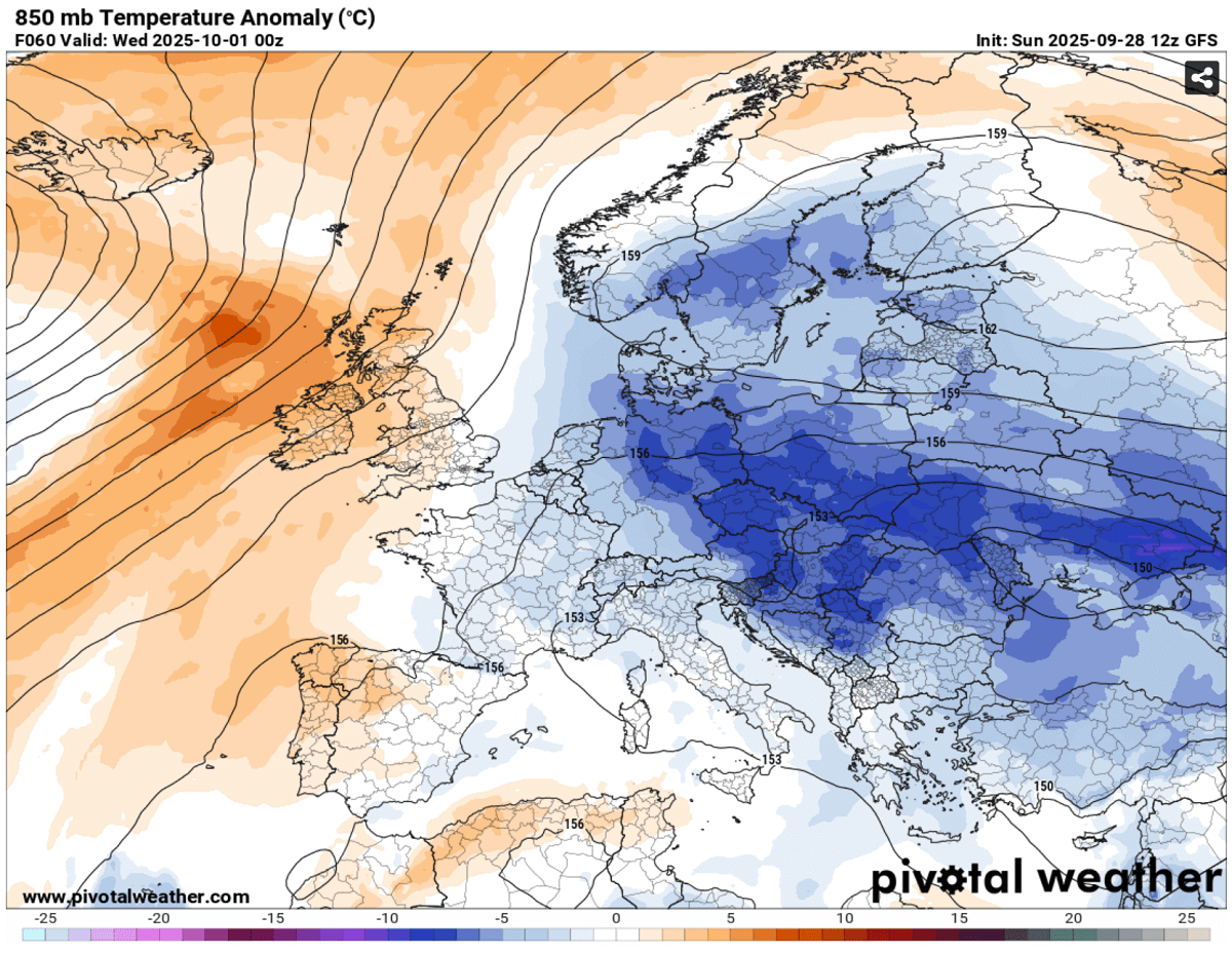
As the cold pool from Eastern Europe deepens and spreads west, temperatures will drop below freezing at the 850 mbar level (approximately 1250m above sea level) by Thursday and Friday.
This is around 10 °C below normal for early October, and these temperatures will be the coldest so far for a large part of the continent this meteorological autumn 2025.
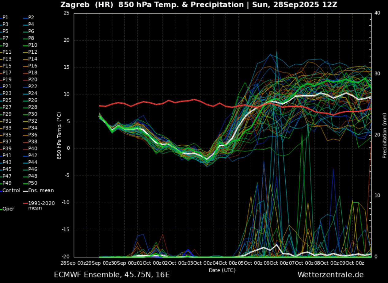
Aside note: Notice the quite sharp warming up that is forecast to follow into the next weekend, likely. There are increasing chances that this strong cold pool will be replaced with more warmth heading into mid-October. This becomes possible as the North Atlantic establishes zonal flow again, with deep cyclones dragging a much warmer air mass onto the continent once the cold pool vanishes.
But this is far in advance; we will first focus on the upcoming cold outbreak.
The following video animation overview reveals the general trends and temperature forecast over the next 7 days. This week’s intensifying cold outbreak will be followed by the return of warmth later.
Let’s dig into the details of the evolution of weather patterns throughout this autumn’s first significant cold outbreak.
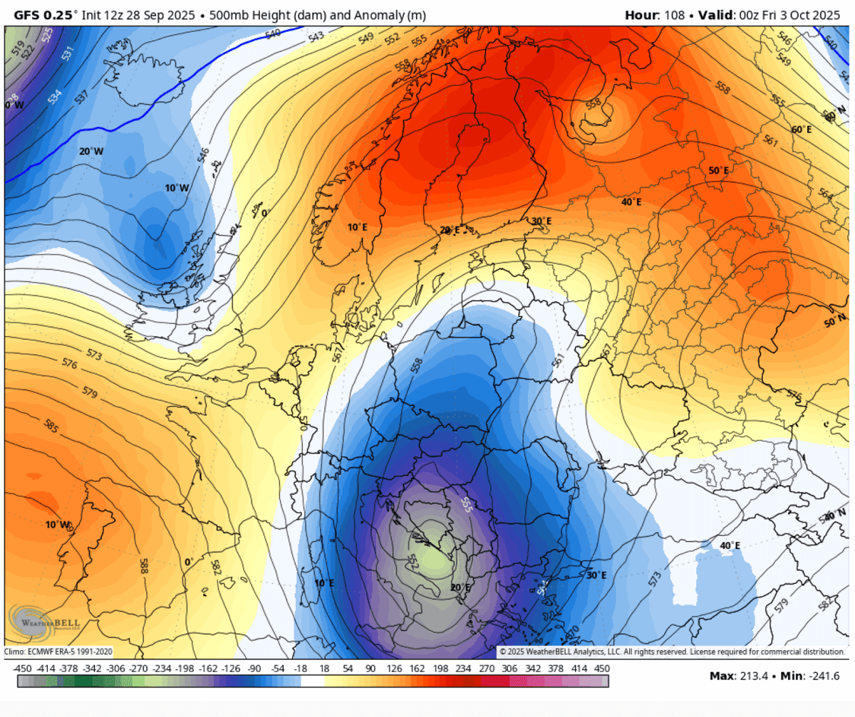
Rex blocking pattern develops over Europe – High over Low brings significant cold outbreak
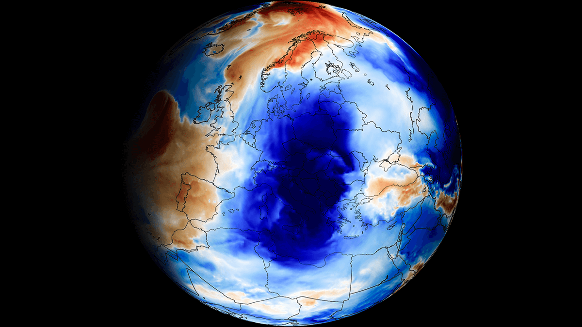
Into the final days of September, a textbook example of a so-called Rex blocking pattern established over Europe. This pattern occurs when a large upper-level ridge is located due north of the upper low.
As of this Monday, an extensive blocking High is centered over northern Europe, while an upper wave is located to its south, centered over western Ukraine. This low gradually moves west-southwest, in response to a reversed flow around the block.
The surface pressure chart over Europe and the North Atlantic hints that a powerful high-pressure system is dominating the European continent this week, while deep lows remain over the far north and northwest Atlantic Ocean.
The general flow usually travels from High to Low, meaning the winds over Europe have turned east-northeast, delivering a colder air mass from Russia into Eastern Europe and further west/south.
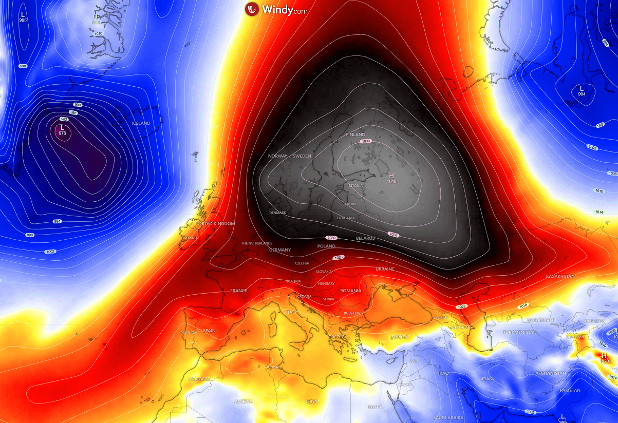
The cold pool builds up, gradually intensifies, and extends through mid-week while the high-pressure system persists, with the central pressure around 1040 mbar.
Over the next few days, the colder air mass will gradually spread west towards Central Europe and south across the Balkan peninsula.
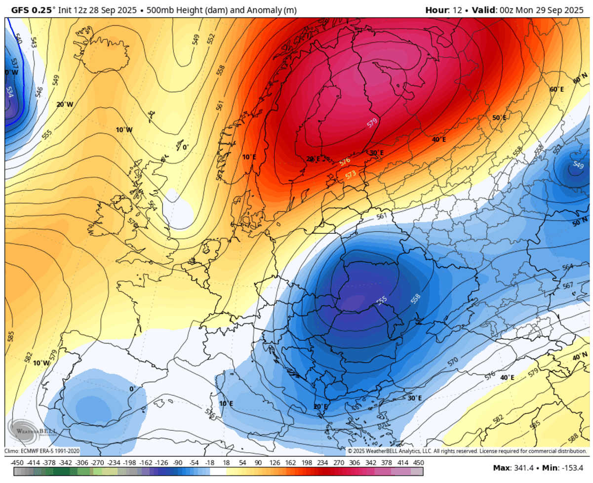
By Friday, the blocking highs had shifted from northern to eastern Europe, and Western Russia had established a strong cold flow into Europe.
So, the upper wave considerably deepens after Thursday with the arrival of a much colder air mass, and the core intensifies over the Balkans and the Mediterranean.
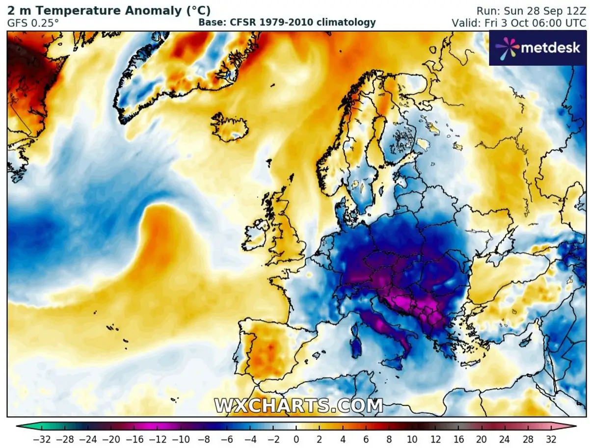
This is when the most significant cold outbreak develops. An 8-12 °C colder air mass spreads from Eastern Europe into the Balkans, Central Europe, and the Central Mediterranean, a pretty unusual cold for early October.
The cold pool will remain intense from Thursday through Saturday, with the most anomalous temperatures over the Western Balkans, the Adriatic Sea, and south-central Italy.

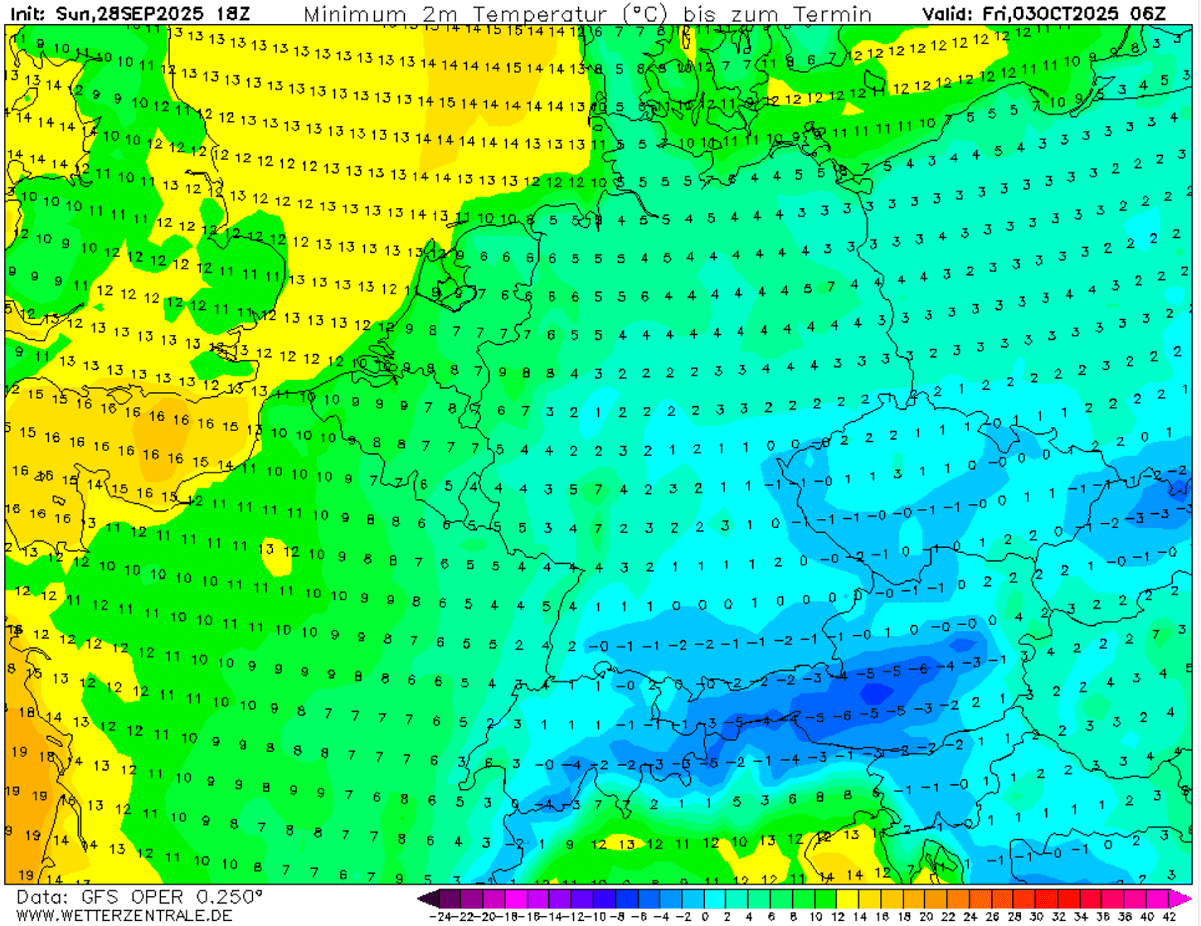
A cold air mass will overspread a large part of the continent, and Friday will be significantly colder than usual for Germany, the Czech Republic, Slovakia, Poland, Austria, Hungary, Romania, Italy, Slovenia, Croatia, and all the western Balkan countries.
At the start of October, temperatures will be more than 15 degrees Celsius colder than usual. For the first time this autumn season, 2025, many countries will see near or below freezing temperatures.
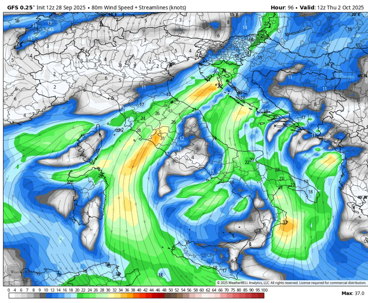
Intense pressure and temperature contrast between the Balkan peninsula and the Mediterranean will establish a persistent northeast flow (downslope winds, known as Bora) along the Adriatic Coast from the Dinaric mountain range and from the Apennines mountain range into the Tyrrhenian coast.
Peak wind gusts will locally exceed 120 km/h.
The cold pool will extend into the following weekend. Then, the changing general weather pattern could bring temperatures back to normal for early October and bring back the warmth from the West.
Unusually strong cold outbreak brings the first frost of the season
The cold pool progress will expand into central Europe after Wednesday and reach its peak on Friday. This means the lowest temperatures are forecast on Thursday and Friday over Germany, the Czech Republic, Slovakia, Austria, Hungary, and Slovenia.
Temperatures will bottom out around 0 °C, or a degree or two below freezing, and there will likely be the first frost of this autumn season. Temperatures in the higher Alps will be frigid for early October, around -10 °C at 2500 metres above sea level and even lower at higher elevations.
With the cold core peaking on Friday while drifting south towards Saturday, the coldest air mass will reach the western and southern Balkans over the weekend. The cold airmass will also spread deep south and west into the Mediterranean, pushing higher elevations over central Italy below freezing.
It appears likely that the coldest temperatures will be observed over the Balkans, from -2 to -4 °C in Gorski Kotar, Croatia, to around -5 °C in Bosnia and Herzegovina and Montenegro. On Saturday, southern Serbia, Kosovo, North Macedonia, and western Bulgaria will see morning temperatures from -2 to -6 °C.
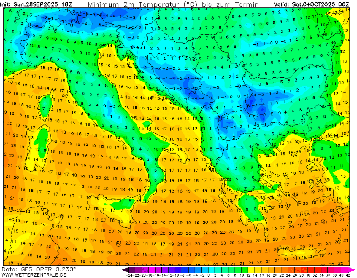
This is a significantly cold period with very low temperatures for early October. Some locations will experience temperatures that haven’t been this cold for decades during this period. Strong northeast winds will also help the real feel even lower, with wind chill temperatures near or below -10 °C.
The position of the cold core aloft over the Western Balkans and the Adriatic region typically brings a lot of precipitation into the southern Balkans, as warmer air from the south Mediterranean meets with the cold and dumps rainfall and storms into Greece.
With air mass this cold, snowfall is also expected across higher elevations from southern Bosnia and Herzegovina, Montenegro, Kosovo, northeast Albania, North Macedonia, and western Bulgaria. Some areas could receive up to around 50cm of fresh snow from Thursday through Sunday.
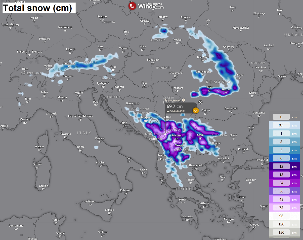
Some fresh snow is also possible over the higher Alps and the Carpathian Mountains in Romania.
We are closely monitoring the evolution of weather patterns. Next weekend, a potentially powerful North Atlantic storm could impact northwest Europe. We will update the forecasts once more details are available. Stay tuned.
Wxcharts, WeatherBell, and Pivotalweather provided images for this article.
See also: