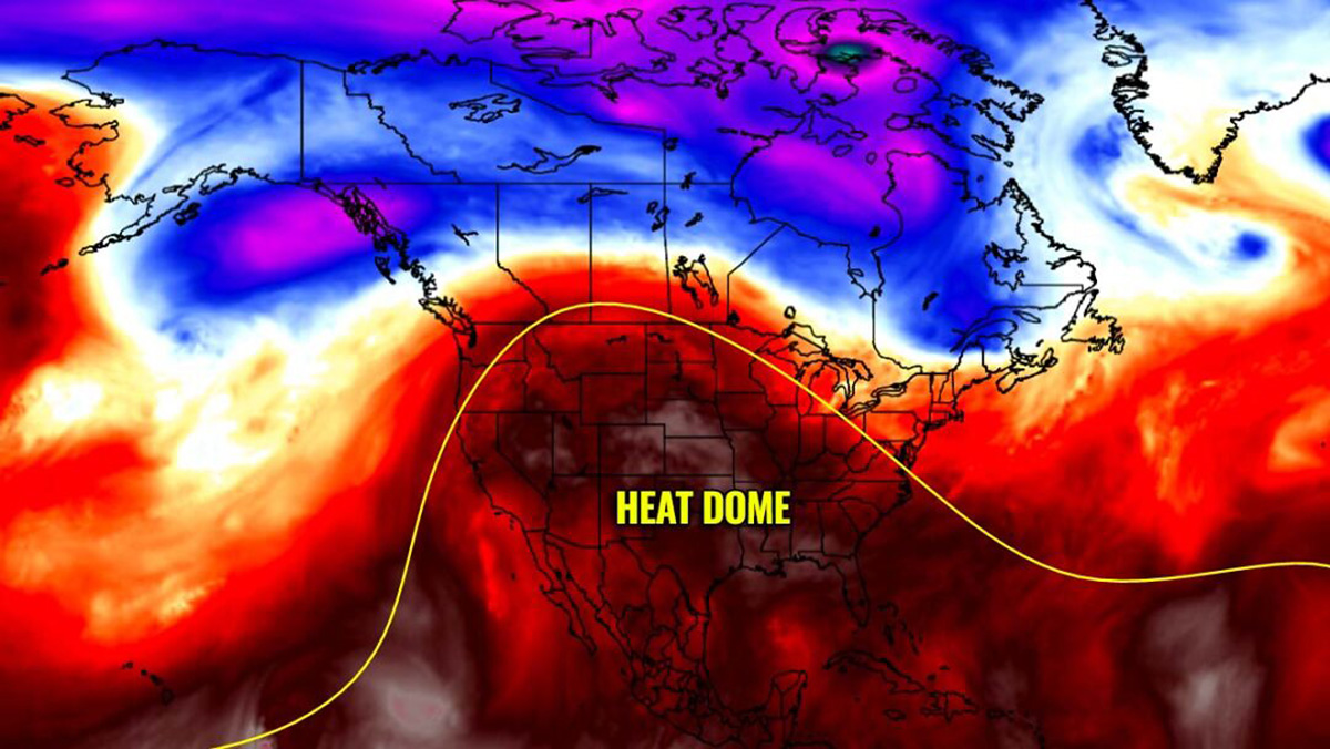
The Christmas Holidays will be more like late spring than late December this year. Weather models hint at a powerful upper-level ridge forecast across large parts of the United States, establishing a classic heat dome. This will send temperatures well above the late-December normals. Potentially resulting in the warmest Christmas Day since the 1950s, so don’t put the swimsuit away just yet.
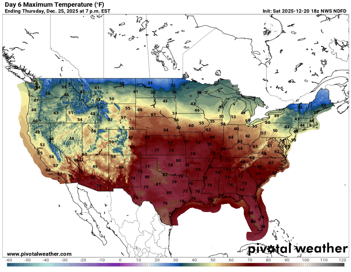
Daily Highs will be in the low 80s in parts of Texas and Oklahoma, mid to upper 70s from Kansas to Illinois and Tennessee, and in the mid to upper 60s across Nebraska and South Dakota.
*** The weather forecast suggests tens of millions of people across the United States will likely experience the warmest Christmas Day on record.
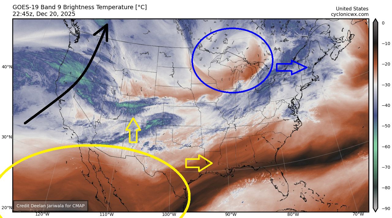
A quick look over the satellite view across the United States reveals three important large-scale features that will play a role in the upcoming historic weather event.
One is the deep low emerging over Ontario, crossing the Upper Midwest into the Great Lakes, bringing the final cold spell and snow towards the Northeast U.S., while further west, there’s another deep low over the Pacific. This low will deliver more rain and floods for the Pacific Northwest.
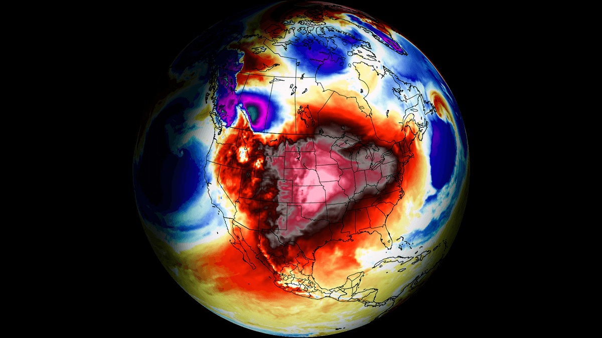
But the main feature of interest is the major upper-level ridge that is expanding from the desert Southwest towards the north and east. This heat will spread across the nation in the coming days, leading to record highs in the lowlands during the Christmas holidays.
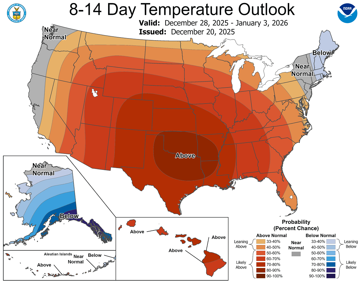
According to the NOAA temperature outlook through the end of the month, most of the CONUS will experience above-normal temperatures.
The only regions with near-normal temperatures will be the Pacific Northwest and the far Northeast U.S., and indeed Alaska, where the extreme, frigid cold has no plans to vanish anytime soon.
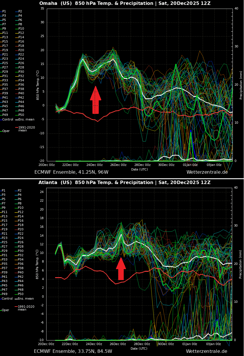
How significantly warm will the days ahead be? It is best to present on the temperature anomaly chart, with a Meteogram chart, for example. The following two charts indicate the temperature and precipitation forecast for Omaha, NE, and Atlanta, GA, over the next two weeks.
We can see an extreme temperature anomaly will develop across the nation, which is 20-25 degrees above normal. And no precipitation is forecast, either, which means dry, unseasonably warm days that will feel like spring.
The weather pattern that leads to such unusually warm periods and historic events is related to the so-called heat dome. Meteorologists use this term when an unprecedented and record-breaking heat forecast is expected.
Let’s examine this large-scale feature and why understanding its behavior is essential.
What is a Heat Dome?
When significant and historic record-breaking warm waves or heatwaves occurred in the United States, Canada, or Europe in the past, the Heat Dome was a contributing factor. The heat dome is usually the dominant feature of summer weather patterns on both continents. But it can occur in the wintertime as well.
We refer to this phenomenon as a heat dome when extremely high temperatures develop. Here’s how it works and why understanding it on a broader scale is essential.
The upper-level ridge pattern, or very warm air mass in the higher altitudes, also known as the Upper High (or blocking High), usually forms the heat dome. This weather pattern brings high, sometimes record-breaking temperatures to the region below.

This term is used when a broad area of high-pressure air parks over a large portion of the continent. If the event is remarkably stable and extreme, it usually lasts several days or weeks.
The heat dome works like a lid on a pot. The extensive dome traps warm air at all levels underneath, with layers sinking toward the ground. Therefore, the air mass becomes anomalously warm at the lowest elevations and extremely warm or hot near the surface.
During summer months, the excessive heat in heat domes can significantly impact human health and be dangerous for particularly vulnerable populations, such as elderly individuals, children, and those with pre-existing health conditions that can worsen in extreme heat.
Due to prolonged exposure to high temperatures, construction workers, farmers, and agricultural workers who work outdoors for long hours are at increased risk of heat-related illnesses. People living in poverty are also more susceptible to the fatalities of heat domes, as their houses are often built with heat-trapping surfaces such as concrete and asbestos.
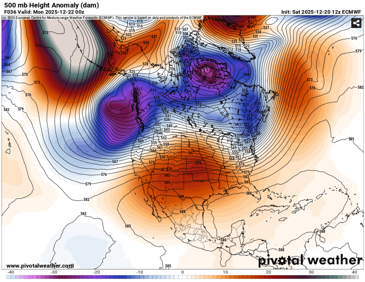
A powerful Omega blocking High will dominate the Contiguous US through the Christmas Holidays
The weather pattern across North America begins its flip into a warmer phase starting Sunday into Monday, with a subtropical ridge expanding from the desert Southwest across the Rockies and onto the Great Plains.
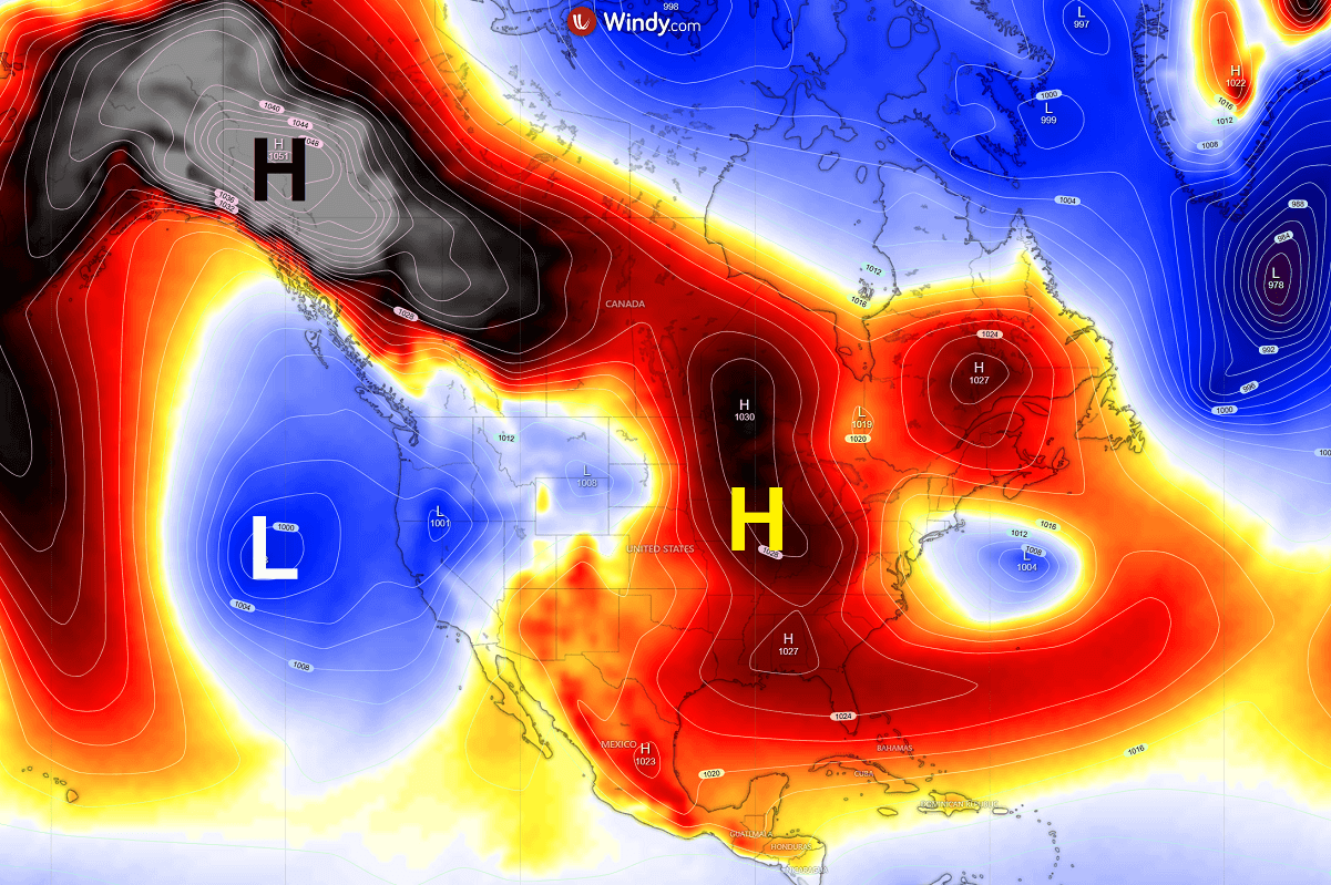
The broader picture across the continent also reveals there’s a robust upper High over the Bering Sea and Alaska, with a deep low over the northern Pacific. This causes a locked-in pattern that expands a broad ridge into the continent.
Establishing a similar picture at the surface. An extremely high-pressure system dominates Alaska and Western Canada; low pressure sits over the Pacific.
While the central parts of the continent see a gradual increase in pressure over the coming days, due to the heat dome and a strengthening upper-level ridge aloft, this is a classic occurrence when this pattern is established.
Temperatures rise significantly starting Monday, with the majority of the Contiguous United States experiencing above-normal daytime temperatures. The warmth is the most pronounced in the central parts of the country. This is where the strongest subsidence of the air masses aloft will occur.
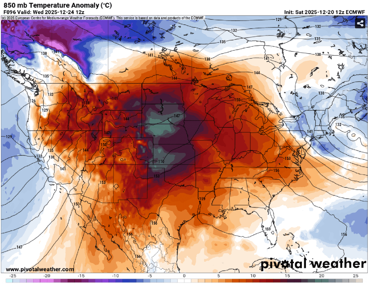
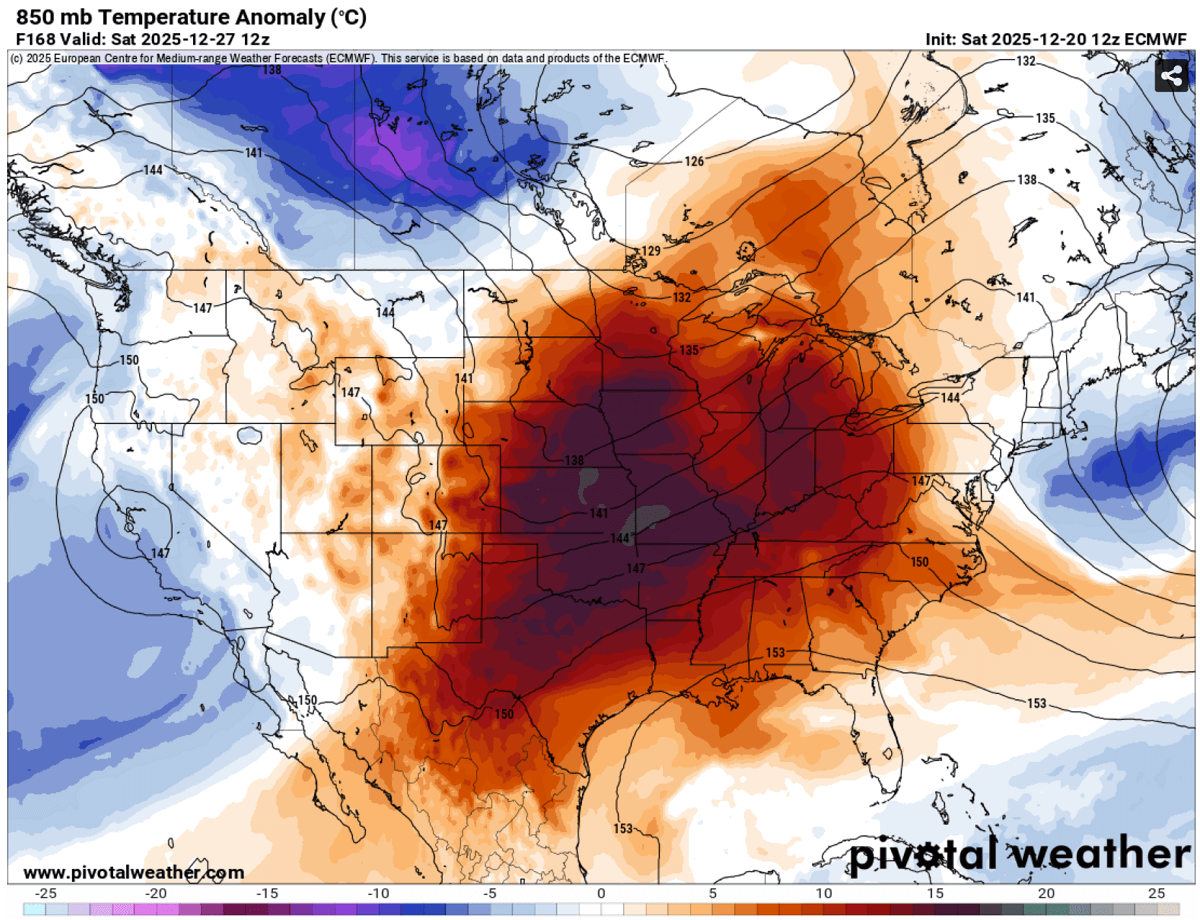
The temperatures in the lowest levels of the atmosphere are very high. Monday and Tuesday will have the highest temperature anomalies across the Midwest, with near-20 °C above normal at the 850 mbar level, as shown on the chart. That is, translated into Fahrenheit, around 30-35 °F above.
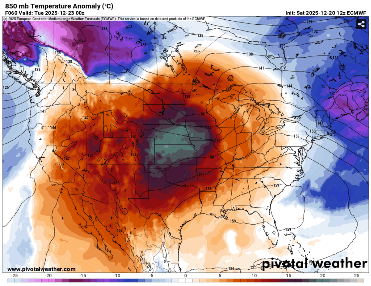
By Wednesday, the warmth strengthens even further, as the dome aloft parks over the central and northern Great Plains. This means the warmest air masses will be over Montana, Wyoming, and the Dakotas, extending into Nebraska, Kansas, Oklahoma, and Texas.
Temperatures will again be around 35°F above normal at the end of December.
Temperatures for many will already be in record-high territory, likely breaking their daily records from Tuesday onwards, and will continue throughout Christmas Day and the holidays.
Christmas Day forecast: Likely the warmest holidays in 70 years
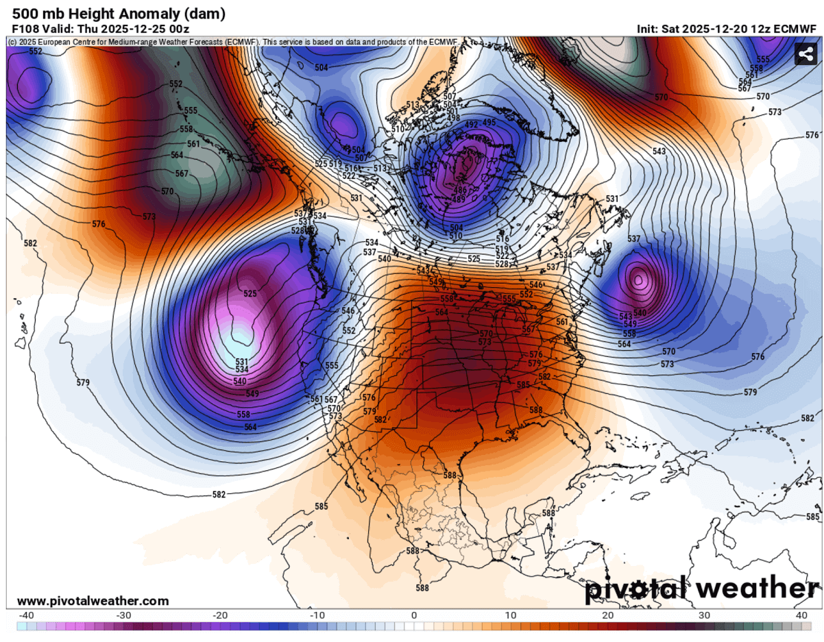
Right on Christmas Day, the Omega blocking pattern reaches its peak across North America, centered over the United States, with a literally picture-perfect upper-level pattern on the continent.
Notice a powerful upper ridge in the middle, with two deep waves on each side. One intense deep low along the Pacific Northwest and another over Atlantic Canada. This is how dominant the pattern becomes around the Christmas holidays, with fully stable weather for most of the Contiguous U.S.
Temperatures in the lowest levels will be extremely high, with nearly 25 °C at the 850 mbar level across Nebraska, South Dakota, Iowa, and Minnesota. So, more than 35 °F above normal. This is extreme and at record levels for Christmas Day.
Notice there will also be extremely warm temperatures across the High Plains, over Kansas, Missouri, Oklahoma, North Dakota, and Wisconsin.
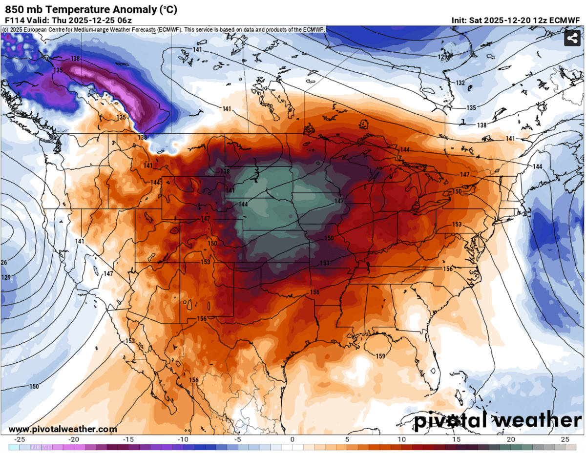
If we translate these into the lowlands, Christmas Day will bring the warmest holidays since the 1950s. The most anomalous temperatures will be from South Dakota to Kansas and Oklahoma, and further east across Missouri to Illinois and Indiana.
The lower altitude here also plays a significant role. Imagine the subsiding air mass from the higher levels has more time to warm up further before reaching ground levels and descending directly from the core of the heat dome aloft.
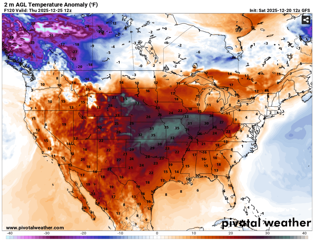
So, the Highest temperatures on Christmas are forecast to reach the 60s across southern Dakota, Nebraska, and Iowa, and further east across northern Illinois and Indiana. The temperature in Chicago could get into the upper 50s on Christmas Day.
Further south, temperatures will push into near- or above-historic record values for millions across the Plains, with mid-70s across Kansas, low 80s over Oklahoma and Texas, and low to mid-80s.
Christmas will be the warmest day of the holiday week, although the heat dome and unseasonal warmth are likely to continue into the following weekend.
Some mid-range weather pattern change trends could bring another cold blast from Canada in the final days of December, while the forecast for Saturday hints it will remain extremely warm for the weekend at least.
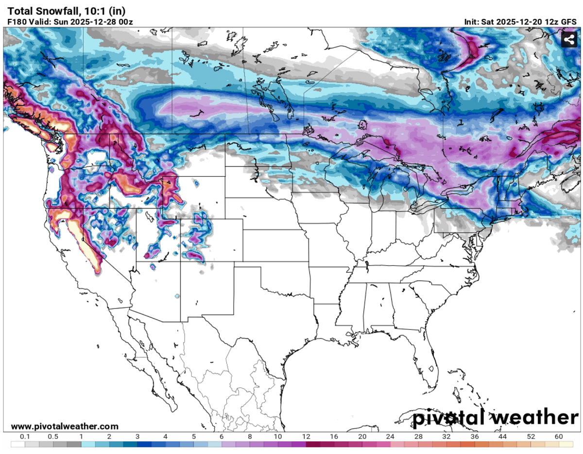
It is more or less evident that, unfortunately, this year, the holidays will not see the classic movie scenes of a white Christmas fairytale.
The final swath of snow is spread with the ongoing low from southern Canada into the Great Lakes. And it will also melt for many across the Plains if any snow is still on the ground.
We continue to closely monitor the evolution of the progressive patterns across the Northern Hemisphere, with North America and Europe in particular in the coming weeks. Following the unusually early and significant disruption of the Polar Vortex and its split this winter, conditions are prone to rapid changes.
Here is the video overview of patterns and temperatures across North America, Canada, and the United States through the remainder of the year into early 2026. Dynamic changes do not take a break; the frigid cold over Alaska and Yukon will keep the forecasts busy, waiting for the subsequent Arctic intrusion towards the south.
The rapid changes in the weather patterns also bring the start of January quite challenging, as the Polar Vortex aloft is regaining strength after unexpectedly breaking apart at the beginning of the meteorological winter.
Stay tuned for further updates.
Windy, Pivotalweather, and Wxcharts provided images used in this article.