Finally, the non-stop wild cyclones over the North Atlantic are over. The Christmas holiday forecast calls for a shift in the weather pattern over Europe, with a major Rex Block ridge establishing, pushing colder weather into Central Europe, together with some snow. General trends hint at a potential Arctic cold blast around the New Year.
While December was mostly stable and mild for many across Europe, some changes are finally here for the holidays and into the New Year. A strong blocking establishes over the Atlantic into western and northern Europe, flipping the flow to east-northeasterly and bringing the wintry vibes back to the continent. At least for some parts, for now.
The general cooling trends are evident on the meteogram charts. Attached below are the charts for London, UK (upper chart) and Zagreb, Croatia (bottom chart).
Both have a dynamic established, with London showing no precipitation through early January. Meaning the pattern will be stable with no frontal system crossing.
The Zagreb meteogram shows a cold front crossing on Christmas evening, with relatively high chances of snow across parts of the northern Balkan countries, Croatia, and Slovenia.

We can, however, notice that the temperature forecast is wavy and widely spread, indicating increased dynamics are anticipated with the Rex Block established.
Here’s a quick overview of the flipped weather dynamic through the remainder of December into the first days of January. First, a blocking High dominates the Atlantic western Europe, potentially moving westward and allowing an Arctic cold to spread into continental Europe around the New Year.
Let’s examine the weather picture for the Christmas holidays and walk you through the details below.
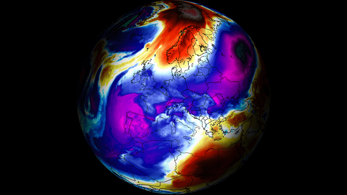
Rex Block weather pattern develops, flips the dynamic over Europe
Compared to the highly dynamic weather pattern over the North Atlantic in recent weeks, the dynamics are about to flip. Over the Atlantic, a strong blocking High develops through midweek, turning the flow into the east-northeasterly.
Meanwhile, an upper trough that is currently emerging into southwestern Europe will get trapped over the Mediterranean, helping to establish a corridor from Russia towards central Europe. A classic so-called Rex Block weather pattern will develop.
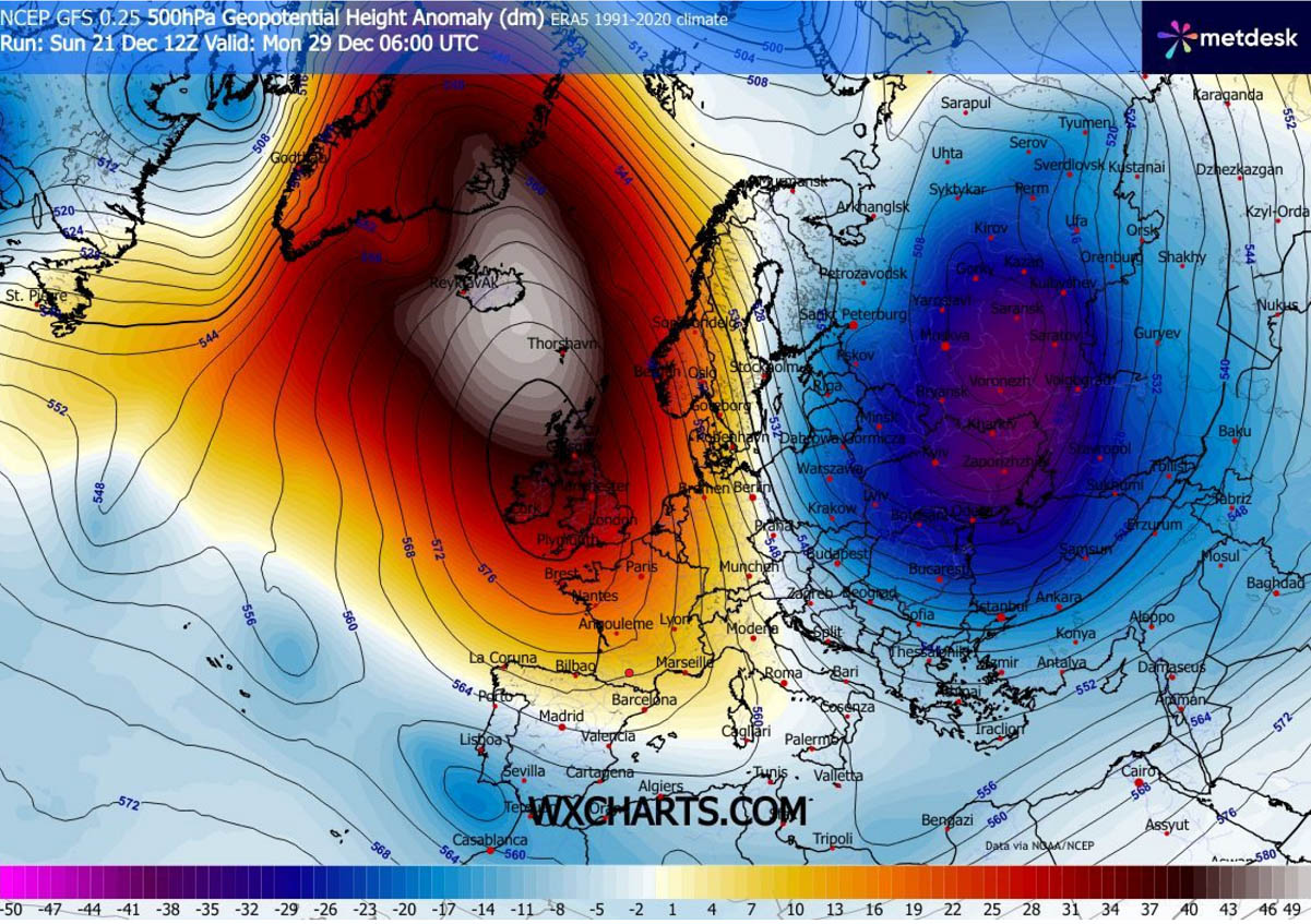
The Rex Block pattern indicates a High over Low weather situation. As shown in the chart below, we will have a Blocking High to the north of the upper low. And with time, this pattern is forecast to intensify towards Christmas.
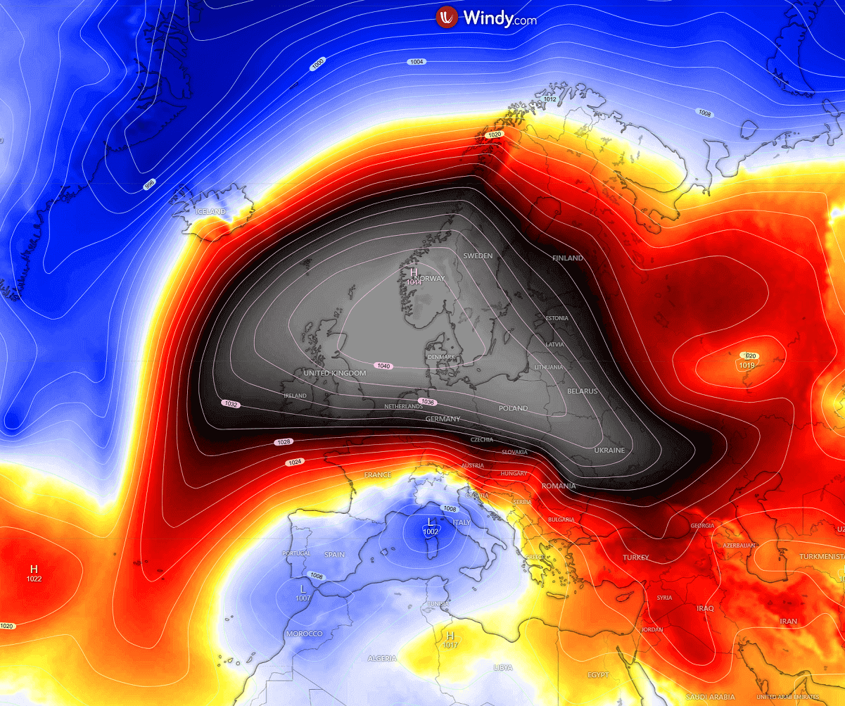
A similar, even more defined, system will be evident on the surface charts, with a powerful high-pressure system dominating most of Europe across the Christmas holidays. The central pressure will be around 1045 mbar over southern Scandinavia. While a surface low maintains over the Mediterranean, a cold upper core lies above it.
Judging from the isobars (lines connecting points of equal pressure), the winds across the Balkans and Central Europe will be easterly and strong. Hence, strong to occasionally severe downslope Bora winds will develop along the Adriatic Sea.
The far North Atlantic will experience strong southwesterly flow, delivering a warm air mass towards Iceland and Greenland.
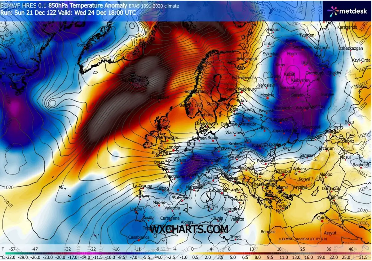
Following the flipped pattern, the airflow from Russia across Eastern Europe towards the Balkans, Central Europe, and further into Iberia will bring colder air. Not particularly cold, but at least near normal for the end of December. The coldest core, however, will remain over western Russia and Ukraine.
Notice an intense warm wave across the Atlantic, on the western edge of the ridge. Sending an extremely warm air mass to the Faroe Islands, Iceland, and towards Svalbard. Christmas Day will undoubtedly be among the warmest years on record there.
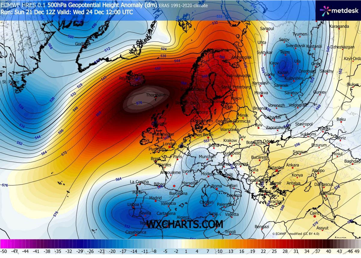
On Christmas Day, the Rex Block pattern reaches its peak. It has an impressive height anomaly in its center over Scandinavia and northwestern Europe. Blocking the western flow completely, as the winds reverse this week.
The Low over the Mediterranean also gradually shifts westward around Christmas, being centered over the Bay of Biscay and the Iberian Peninsula.

The corridor between the blocking High on the north and the upper low over the west-central Mediterranean region will establish an east-west flow across the Balkans and Central Europe. So, the temperatures will be cold enough to support snowfall in many areas around the Alps, across the Balkans, and in southern France towards the higher northern Spain.
Around 15-30 cm of fresh snow could accumulate through Friday at some spots, especially where the orographic effects of the east-northeast low-level winds will be the most pronounced. Particularly across the Alps, the northern Dinaric mountain range in the Balkans, and the southern Balkan peninsula (Romania and western Bulgaria).
Some traces of snow and minor snow accumulations, or moderate snowfall, seem possible across central France and Spain, the western Balkans, Hungary, Austria, and southern Germany.
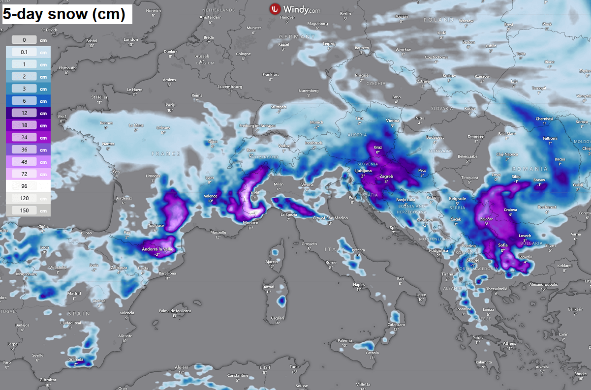
This means that Christmas Day will be snowy in these areas, so at least some holiday spirit, while the rest of Europe (apart from the far northern Europe) will unfortunately be lacking snow for Christmas this year.
Further south of the Alps, the air mass will be warmer, so quite a lot of rain is forecast across the north-central Mediterranean. With locally rainfall accumulations reaching 100-150 mm until Friday.
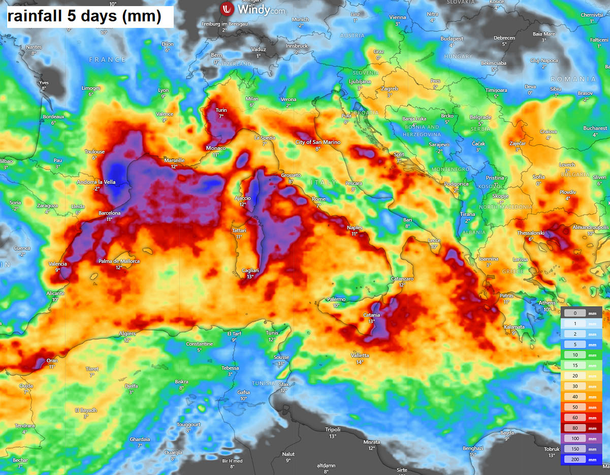
Further north, across western and northern Europe, a major Rex blocking High will ensure stable weather, with no significant rainfall or snowfall events at least until the following weekend.
Potential increases for Arctic cold outbreaks around the New Year
The general trends forecast for after the Christmas holidays now also suggest that further dynamics are likely to follow. According to both global weather models, there is an increasing likelihood of a large dipole pattern forming over Europe and the Atlantic.
This means that an extensive blocking High takes place over the North Atlantic while a deep upper-level trough digs south across the European continent.
Given that it’s still a week in advance, uncertainties remain about where the blocking High and the deep low would form. The farther west they create, the more southward and westward the Arctic cold air mass would push.
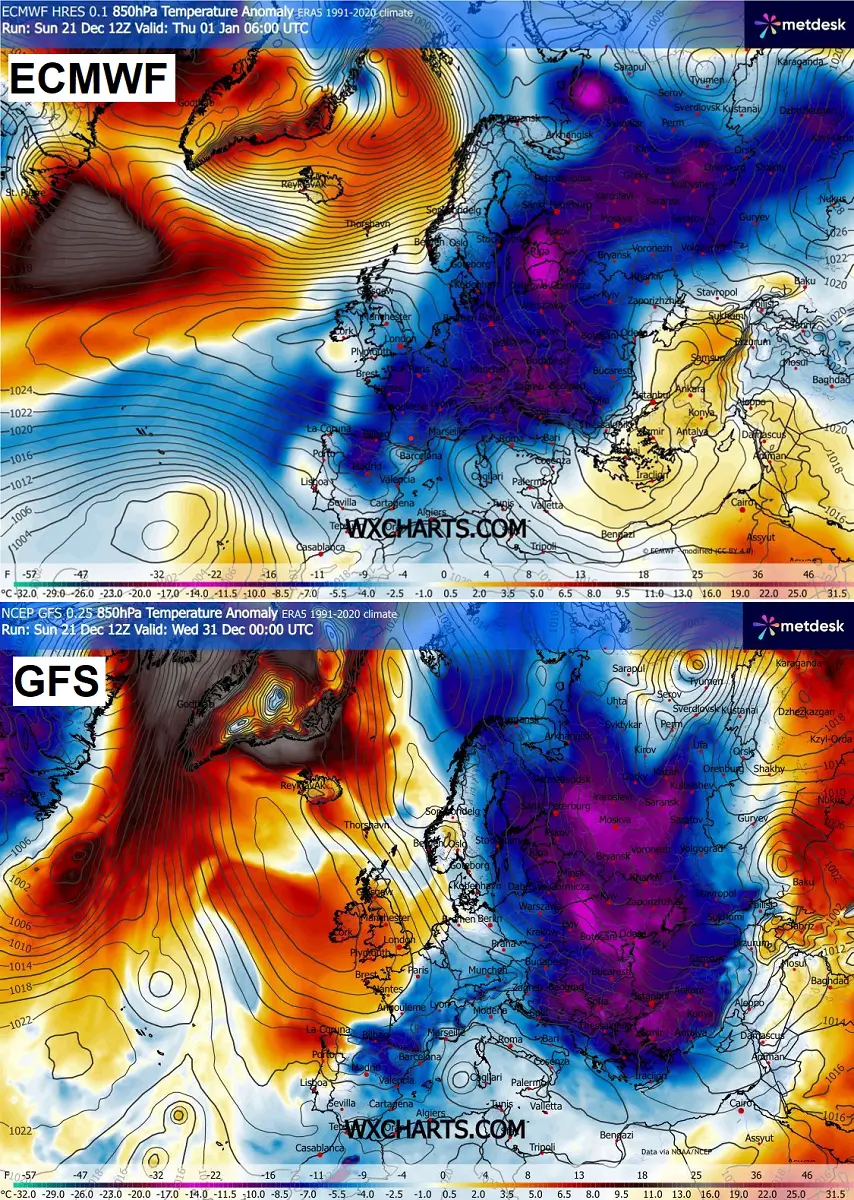
Both GSF and ECMWF models, however, do show good agreement that the large Arctic cold pool is likely to establish in the north in the final days of the year, gradually spreading towards the south.
The ECMWF solution sends the Arctic cold outbreak into Central Europe, while the GFS model sends the majority of the cold across Eastern Europe and the Balkans.
It is definitely advised to continue monitoring the evolution of the flipped pattern, as the strong dynamics are now back over Europe, with more wintry cold weather forecast, compared to the unusually stable weather most of December so far.
These significant changes in the weather patterns also bring the start of January quite challenging, as the Polar Vortex aloft is regaining strength after an unusually early split at the beginning of the meteorological winter.
Stay tuned for further updates.