The unusual Atlantic Hurricane Season 2025 continues to surprise. While there has been below-average activity this year, Tropical Storm Melissa is now explosively developing in the Caribbean Sea. Melissa is forecast to become the next Category 5 storm, impacting Jamaica, Haiti, and Cuba with potentially destructive flooding and landslides.
According to the National Hurricane Center (NHC), life-threatening and catastrophic flash flooding and landslides are expected in portions of southern Hispaniola and Jamaica through the weekend as Melissa is undergoing rapid intensification and heading for major hurricane strength soon.
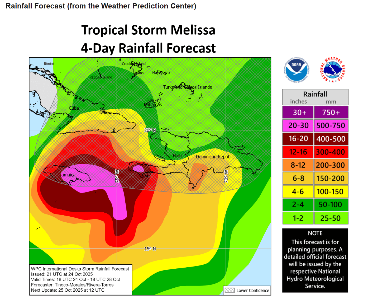
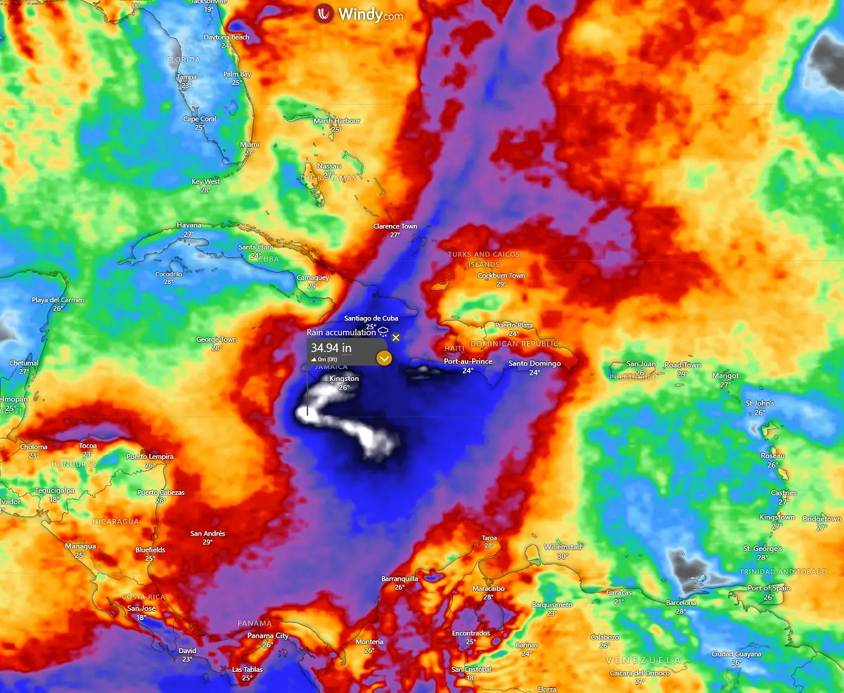
Extreme amounts of rain are forecast, potentially reaching more than 40″ (1000 mm) along Hurricane Melissa’s path. Destructive winds will also occur as Melissa becomes a major storm soon.
Here are the Key Messages for the most affected areas in the coming days:
JAMAICA
Due to Melissa’s slow motion, a prolonged multi-day period of damaging winds, heavy rainfall, potentially catastrophic flash flooding, and numerous landslides will likely begin late Saturday or Sunday.
There is an increasing risk of life-threatening storm surge when the center of Melissa nears Jamaica early next week. Preparations to protect life and property should be rushed to completion.
HAITI
Heavy rainfall will result in catastrophic flash flooding and landslides across southwestern Haiti into early next week. Extensive damage to roads and buildings is expected, potentially isolating communities for an extended period.
Immediate preparations should be made to protect life and property. Strong winds could also potentially last for a day or more over the Tiburon peninsula of Haiti.
DOMINICAN REPUBLIC
Heavy rainfall could produce potentially catastrophic flash flooding and numerous landslides in the southern portions of the Dominican Republic.
CUBA and BAHAMAS
Interests in Cuba and the Bahamas should monitor Melissa’s progress since there is an increasing risk of a significant storm surge, damaging winds, and heavy rainfall by mid-next week.
The risk of life-threatening flash flooding and landslides in eastern Cuba is increasing.
During an average tropical year, the Atlantic hurricane season produces up to 14 named tropical storms. On average, seven typically become hurricanes, with around 3 reaching major strength.
A typical Atlantic hurricane season has two peaks.
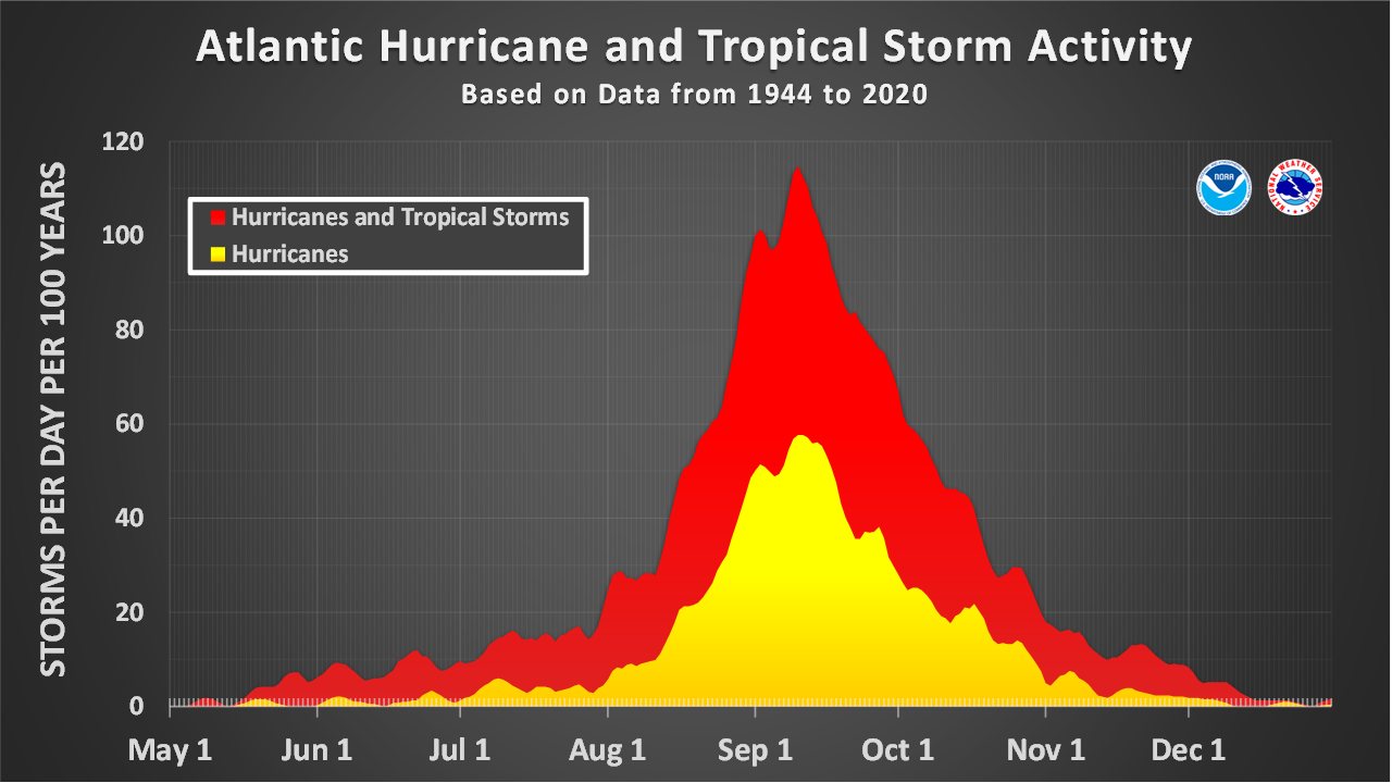
The first period of increased activity occurs from early through mid-September, while the second boost typically happens through mid-October. Statistically, the general increase in activity across the tropical Atlantic generally begins in the trough early/mid-August.
We are now nearing the end of the Atlantic hurricane season 2025, which produced 13 named storms and four hurricanes, three of which were major storms and two Category 5 hurricanes. Melissa will be the 3rd Category 5 storm!
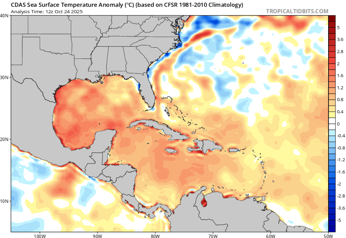
Extremely warm waters of the Caribbean Sea will support the explosive intensification of Melissa
After an unusually slow hurricane season in 2025, the tropical waters of the western Atlantic have remained extremely warm. Temperatures across the Caribbean Sea are in the low 30s, and Melissa is gaining strength here.
The ingesting of these extremely warm sea waters and oceanic heat content will allow Melissa to intensify rapidly and become a major Category hurricane soon.
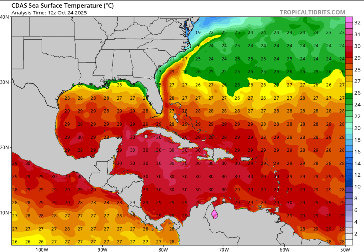
The sea waters across most of the Caribbean Sea are around 2 °C above the long-term average, which is particularly concerning for Melissa’s evolution in the coming days.
Note that extremely warm and anomalous sea waters are the primary reason for explosive storm development near the center of the surface low. High water temperature fuels the storms with high dewpoints, giving them energy to boost the vigorous convection.
This is why we believe Tropical Storm Melissa will become the next Category 5 hurricane in the coming days.
There were already three major (Category 3 or greater) hurricanes this season, with 13 named storms. Hurricane Erin was Category 5, Hurricane Gabrielle was Category 4, and Hurricane Humberto was the next
Category 5 storm.
Storm Melissa will be the 3rd Category 5 hurricane of the Atlantic hurricane season 2025.
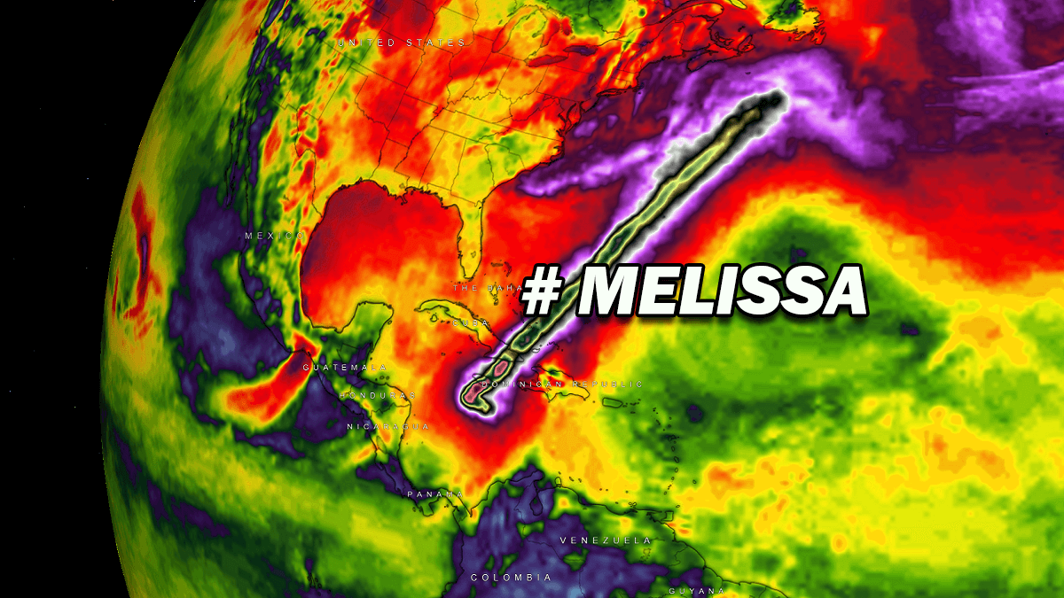
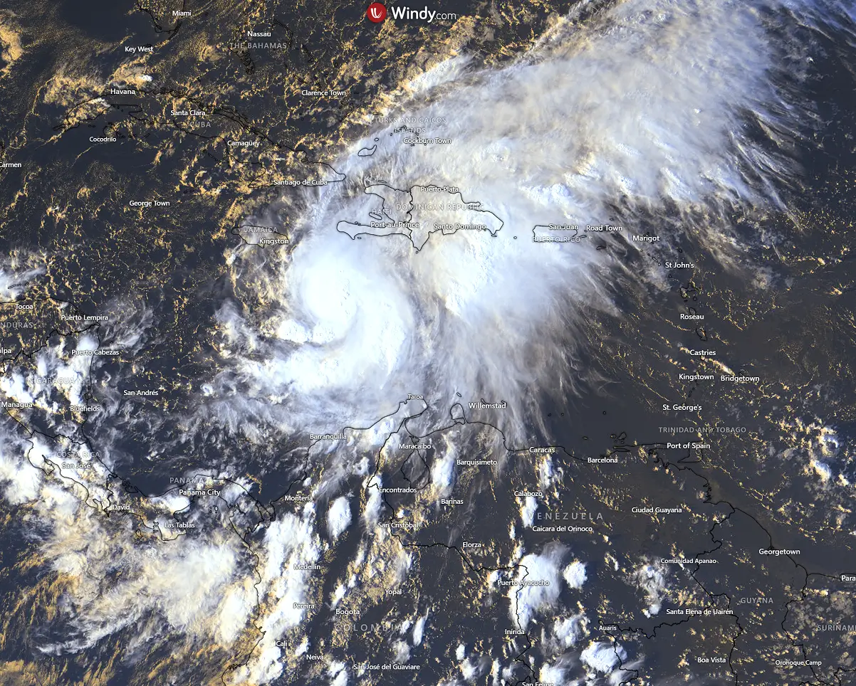
Above: Rapid development of Melissa is underway, and the animation includes multiple satellite channels.
Melissa is forecast to become the next Category 5 hurricane, and bring catastrophic flooding and landslides
Melissa’s satellite presentation suggests a powerful monster storm will churn over the Caribbean. A large upper-level outflow seen on the visible and water vapor satellite spectra suggests that the environment is strongly conducive to explosive tropical development.
The system has become very large and will soon expand further in size and intensity over the weekend.
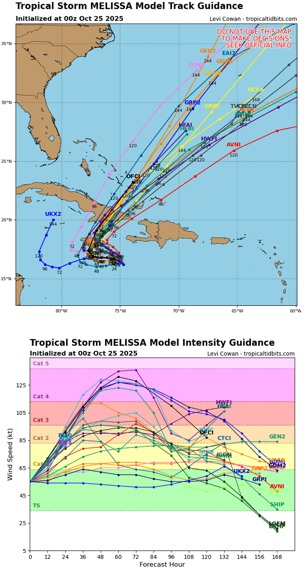
The official National Hurricane Center (NHC) track brings storm Melissa to major hurricane strength by Sunday morning. The system will be moving west extremely slowly, rapidly gaining strength and growing in size.
Hurricane Melissa is forecast to reach Category 5 strength by Monday. The hot oceanic waters of the west-central Caribbean Sea fuel it.
Melissa turns sharply north of Monday and heads for landfall in Jamaica as a monster Category 4 or 5 storm on Tuesday. The impact will be extreme, with catastrophic flooding potential, destructive winds, and deadly landslides.
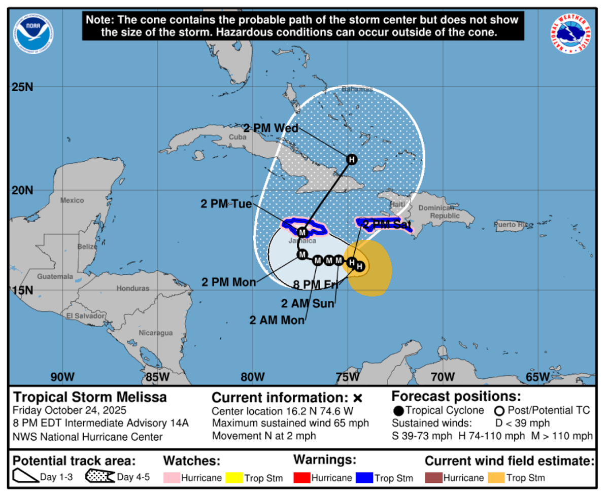
The model forecast regarding Melissa’s track agrees that the major storm will cross Jamaica and impact eastern Cuba next Tuesday night. Then, it will continue northeast and gradually accelerate, moving across the Eastern Bahamas mid-next week.
Most global and high-resolution weather models agree that the storm will rapidly and explosively strengthen through Sunday night, bringing Melissa to a Category 5 strength.
The greatest concern is Hurricane Melissa’s slow progress and movement. It’s slowly advancing over extremely warm sea waters that typically bring torrential downpours with abundant rain.
The impact of the worst storms and the highest rainfall depends on where Melissa’s eye travels. The worst and most robust thunderstorms are around the eye, building up the eyewall structure.
Most weather models suggest 30″ to nearly 50″ (800-1300 mm) of rainfall will be possible. Where these amounts impact the land, they could lead to catastrophic flooding and landslides.
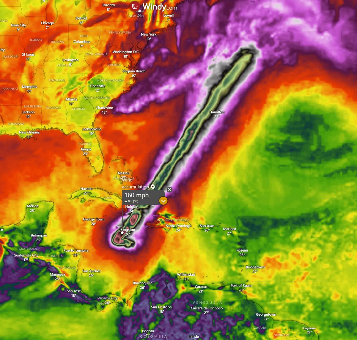
The other concern is the swath of extremely severe winds associated with the vigorous storms inside the eyewall. As Melissa will likely become a Category 5 storm, the sustained winds could exceed 155 mph (250 km/h). This leads to extreme wind damage and life-threatening weather conditions.
After Melissa’s first landfall in Jamaica, it will move northeast across eastern Cuba with a Category 4 or 5 strength. So, the impact will be extreme, similar to that over Jamaica.
Once Melissa moves over Cuba, it will graze across the Eastern Bahamas, remaining a major hurricane or at least Category 3 strength.
After the Bahamas, hurricane Melissa will continue northeast towards Bermuda late next week, gradually weakening and accelerating with the general flow.
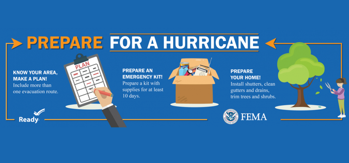
Safety Preparedness during a Hurricane Season
Have a plan
The official hurricane season in the North Atlantic and the Caribbean starts on June 1st and ends on November 30th. This is when you and your family must be prepared by planning.
- Write emergency phone numbers and keep them on the refrigerator or near every phone in your house. It would help if you also programmed them into your cell phone.
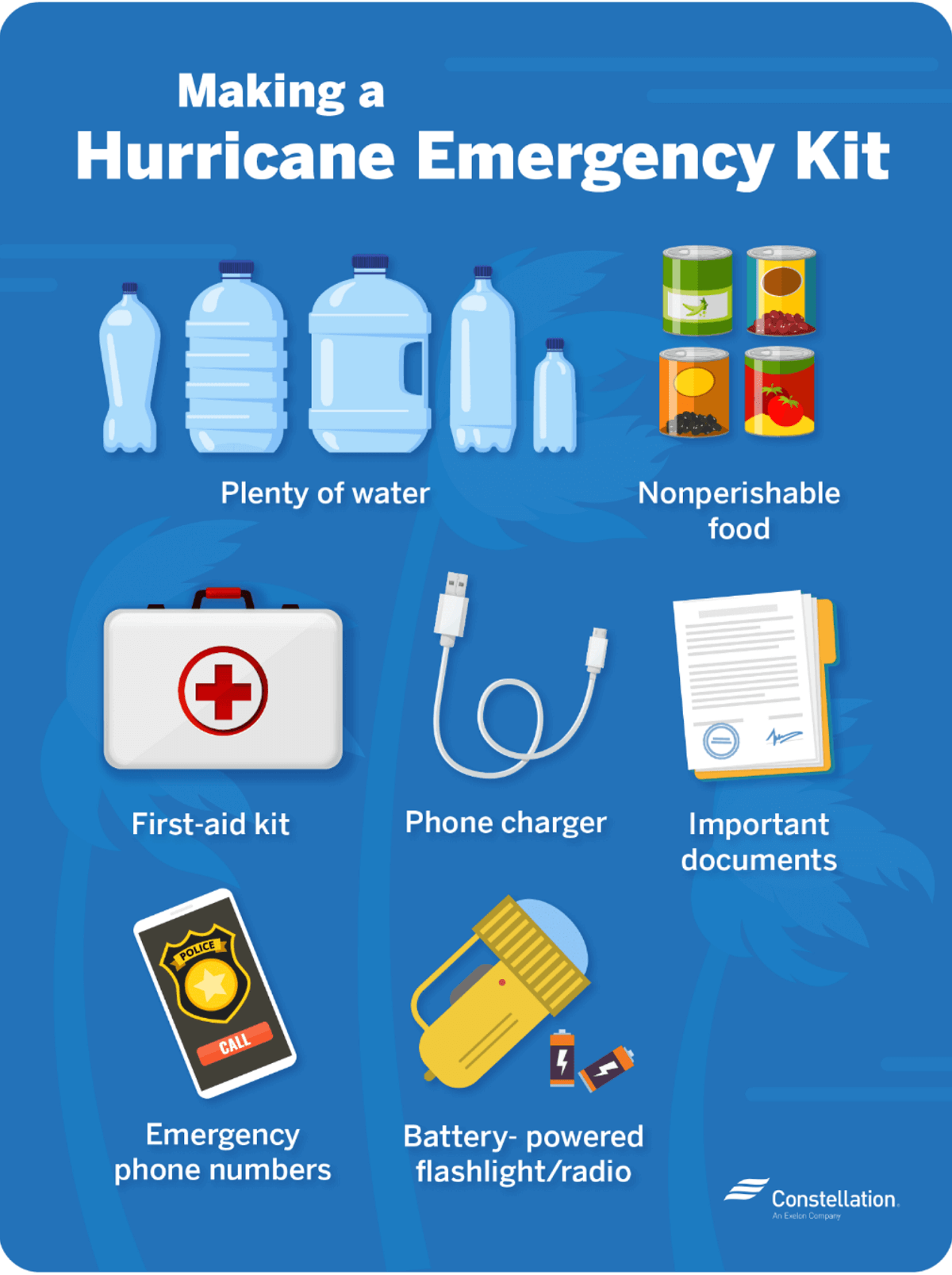
- Prepare an emergency supply kit.
- Locate the nearest shelter in your area and different routes from your home in an emergency. If shelter locations in your area have yet to be identified, learn how to find them before the event of a storm.
- Pet owners: Take care of your pets at pre-identified shelters, a pet-friendly hotel, or an out-of-town friend or relative where you can take your pets in case of an evacuation. Local animal shelters can offer advice on what to do with your pets if you are asked to evacuate your home during a hurricane.
Learn the difference between a hurricane “Watch” and “Warning”
When you listen to the National Weather Service alerts on TV or radio or check for them online, there are two kinds of alerts:
- A hurricane watch means hurricane conditions (sustained winds of 74 miles per hour [mph] or higher) are possible in a stated area. The National Hurricane Center (NHC) will announce hurricane watches 48 hours before it expects tropical storm-force winds (sustained winds of 39 to 73 mph) to start.
- A hurricane warning is a more severe threat. This means that hurricane-force winds are expected in a stated area. NHC issued these warnings 36 hours before tropical-storm-force winds were expected in the area to give people enough time to prepare for the storm.
Check out the National Weather Service’s Hurricane Center for more information about hurricane watches and warnings. If you hear a hurricane watch or warning in your area, you can take steps to get ready.
Get your car ready to leave home if needed
Make sure your car is ready before the tropical storm or hurricane hits.
- Fill the gas in your car’s tank.
- Move cars and trucks into your garage or under cover.
- Always keep an emergency kit in your car.
If you don’t own a car, consider making plans with friends and family or calling the authorities to get a ride if you need to evacuate.
Get your family and pets ready
- Go over your emergency plan with your family; understand everything.
- Keep checking for weather updates about the storm. You can watch TV, listen to the radio, or check the NHC website online.
- Call the hospital, public health department, or the police about special needs. If you or a loved one is older or disabled and won’t be able to leave quickly, get their advice on what to do.
- Put pets and farm animals in a safe place.
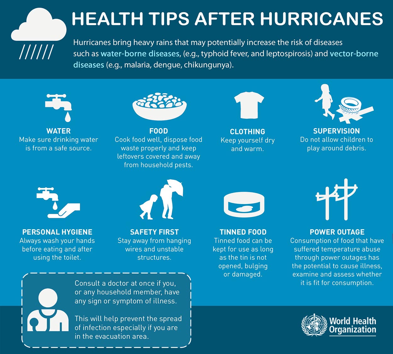
Get your home ready
- Clear your yard to ensure nothing can blow around during the storm and damage your home. Move bikes, lawn furniture, grills, propane tanks, and building materials inside or under the shelter.
- Cover up house windows and doors. Use storm shutters or nail pieces of plywood to the outside window frames to protect your windows. This can help keep you safe from flying debris and pieces of shattered glass.
- Be ready to turn off your power if you see flooding, downed power lines, or have to leave your home. Switch your power off completely.
- If you lose your water supply during the storm, clean containers with drinking water. You can also fill your sinks and bathtubs with water for washing.
- Double-check your carbon monoxide (CO) detector’s battery to prevent CO poisoning.
Be ready to evacuate or stay at home
During a hurricane warning, always listen to authorities regarding whether you should evacuate or stay home.
If a hurricane is coming, you may hear an order from authorities to evacuate (leave your home). Never ignore an order to evacuate. Sturdy, well-built houses may not hold up against a hurricane’s power. Staying home to protect your property is not worth risking your family’s health and safety.
There are occasions when you may hear an order to stay at home. If driving conditions are too dangerous, staying home might be safer than leaving. Respect the authorities’ decisions.
If you need to evacuate:
- Grab your emergency supply kit and only take what you need (cell phone, chargers, medicines, identification like a passport or license, and cash).
- Unplug your appliances. If you have enough time, turn off the gas, electricity, and water.
- Follow the roads emergency workers recommend, even if dense traffic is expected. Other routes might be blocked or already flooded. Never drive through flooded areas, as cars and other vehicles can be swept away or may stall in just 6 inches of moving water.
- Contact your local emergency management office and ask if they offer accommodations for owners and pets.
If you need to stay home:
- Keep your emergency supply kit somewhere you can easily access it anytime.
- Follow weather updates online from NHC, and listen to the radio or TV for updates on the hurricane.
- Stay inside. Even if it looks calm, don’t go outside. Wait until you hear an official message that the hurricane is over. Sometimes, the weather gets calm in the middle of a storm, but then quickly worsens again.
- Stay away from windows. You could get hurt by flying debris, such as pieces of broken glass or other objects picked up by the winds around the neighborhood during the storm. Stay in a room without windows or go inside a closet.
- Be ready to leave home. If emergency authorities order you to leave or your home is severely damaged, you may need to go to a shelter or a neighbor’s house.
Our expert forecaster team will actively follow the tropical region activity worldwide, including Atlantic Basin systems and tropical cyclones likely to affect the United States, the Caribbean, and Europe again in the following months.
NOAA, NHC, Colorado State University, and WHO provided images used in this article.
See also:
Seasonal Weather Change: A New La Niña has Formed, but Strong El Niño Reversal is Forecast for 2026