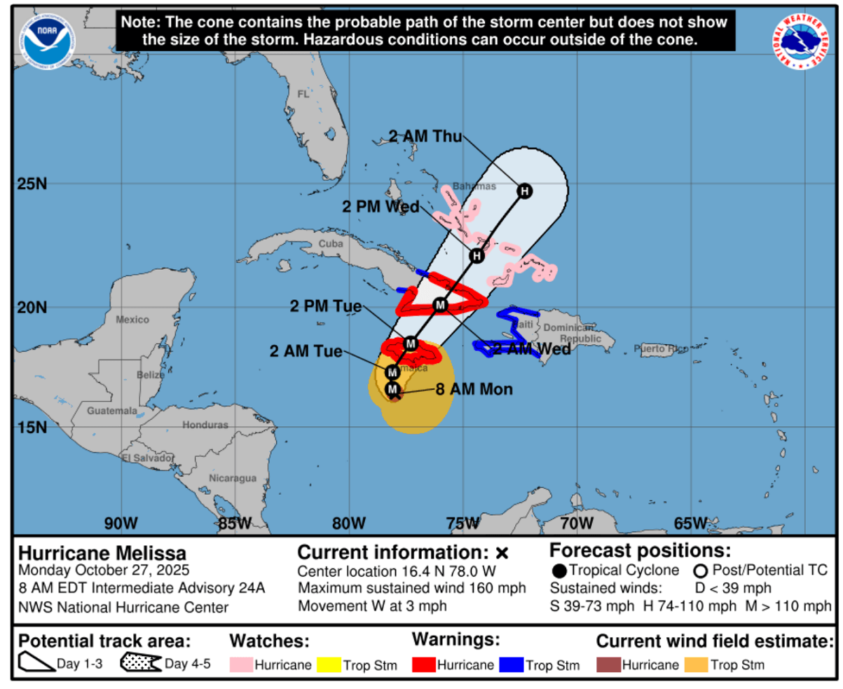
This is the latest update of Category 5 hurricane Melissa, which has become the most intense storm of the year in the North Atlantic Basin. Melissa is soon turning towards Jamaica, where a historic, life-threatening, and catastrophic impact is expected tonight into early Tuesday. Historically, Jamaica has never been hit by a violent storm of this scale.
According to the National Hurricane Center (NHC):
***Life-threatening and catastrophic flash flooding and landslides are expected across southern Jamaica through Monday night and Tuesday, impacted by the historic Category 5 storm still strengthening, with 160 mph sustained winds and a central pressure of around 905 mbar.***
Extreme amounts of rain with deadly flooding are forecast along Hurricane Melissa’s path. As Melissa goes ashore in southern Jamaica on Tuesday morning, destructive winds and a storm surge are also expected.
Here are the Key Messages for the most affected areas in Jamaica, Cuba, and the Bahamas:
JAMAICA
Do not venture out of your safe shelter. Catastrophic and life-threatening flash flooding and numerous landslides are likely today through Tuesday.
Catastrophic winds in the eyewall, especially in higher elevation areas tonight and early Tuesday, potentially cause total structural failure.
This will result in extensive infrastructural damage, long-lasting power and communication outages, and isolated communities.
Life-threatening storm surge and damaging waves are expected along the southern coast through Tuesday.
HAITI and DOMINICAN REPUBLIC
Catastrophic and life-threatening flash flooding and landslides are expected across southwestern Haiti and southern portions of the Dominican Republic through midweek. In Haiti, extensive infrastructural damage and community isolation are likely.
Tropical storm conditions are expected late Tuesday and Wednesday.
EASTERN CUBA
Heavy rainfall, with potentially catastrophic flash flooding and landslides, is expected beginning today. A life-threatening storm surge and damaging winds are expected late Tuesday and Tuesday night. Preparations should be rushed to completion.
SOUTHERN BAHAMAS, and THE TURKS AND CAICOS
Hurricane conditions, life-threatening storm surge, and heavy rainfall are possible on Wednesday.
Residents should follow the advice from local officials and be sure to complete preparations by Tuesday night.
Melissa is the third storm to reach Category 5 strength in the North Atlantic Basin this season and has also become the strongest storm of the year. The other two Category 5 storms were Hurricane Erin and Hurricane Humberto.
Extremely warm waters of the Caribbean Sea led to the explosive intensification of Melissa
The tropical waters of the western Atlantic have remained extremely warm. Temperatures across the Caribbean Sea are in the low 30s, with a broad area having a sea surface temperature of 30-32 °C. The sea waters across most of the Caribbean Sea are around 2 °C above the long-term average.
Melissa took advantage of these hot waters and low wind shear environment, which provided ideal conditions for explosive intensification into a Category 5 storm.
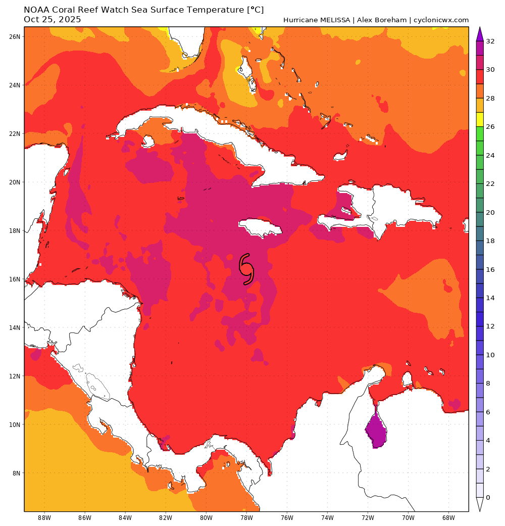
Note that extremely warm sea waters, which result in high oceanic heat content and are combined with a low wind shear environment, are the primary reason that hurricanes intensify extremely rapidly. High water temperature fuels the storms with high dewpoints, giving them energy to fuel vigorous convection.
This has been evident on both satellite and NOAA hurricane hunters’ observations. The automatic satellite DVORAK analysis has shown the rawT number past 8.0, which is extremely rare worldwide. The steep curve reveals how rapidly Melissa intensified since Sunday morning.
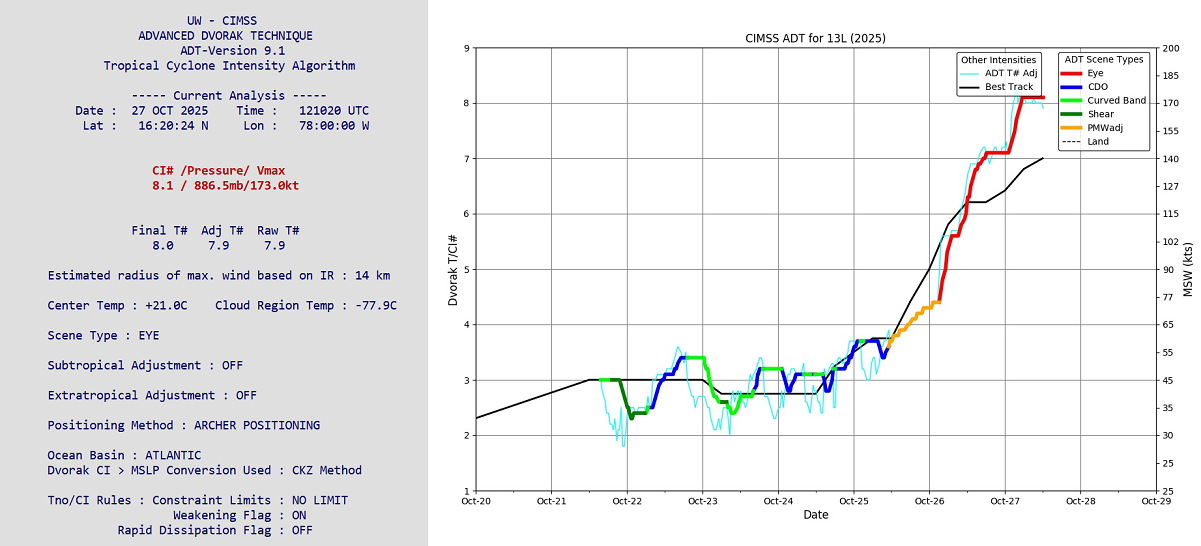
The automatic analysis of cloud tops also suggested winds above 170 knots (195 mph) and central pressure below 890 mbar, slightly overdoing these numbers compared to the NOAA hurricane hunters’ observations.
Hurricane Melissa is a Category 5 storm, packing winds above 160 mph
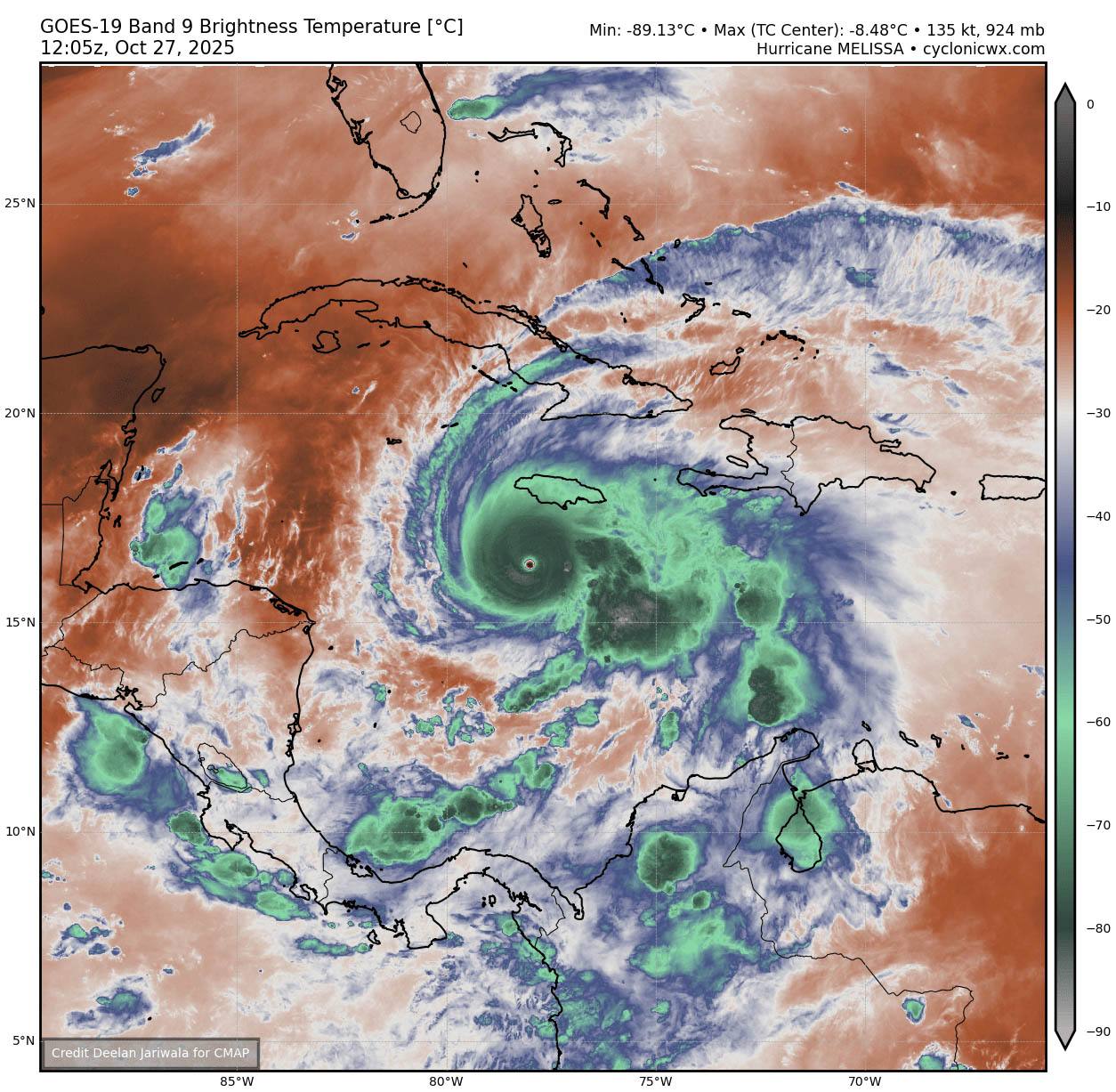
On Monday, strengthening hurricane Melissa is still underway after rapid intensification over the last 36 hours. The following animation includes multiple satellite channels—Infrared, Visible, and Water vapor—revealing how intense the storm has become.
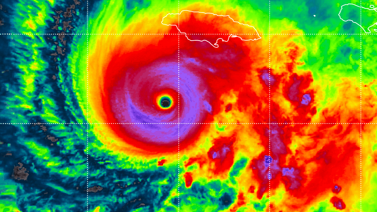
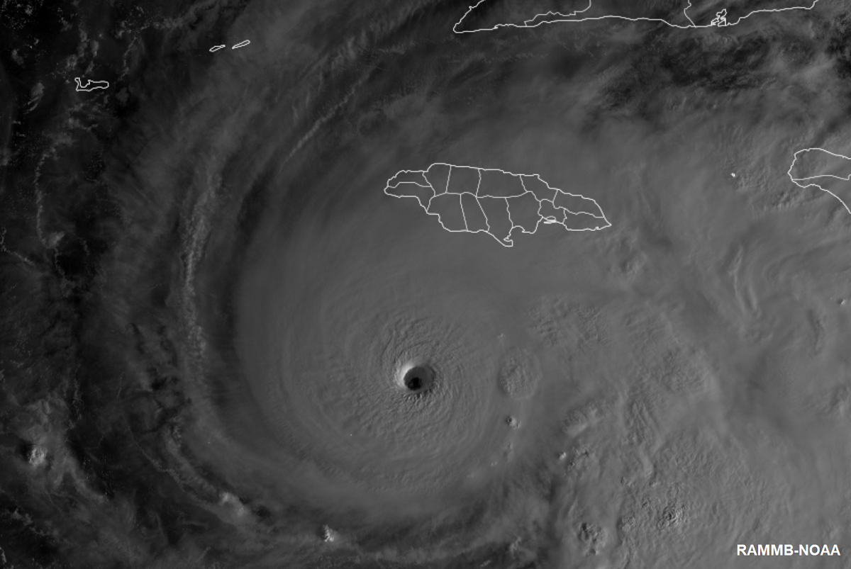
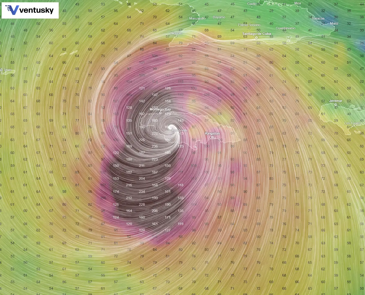
Melissa has the classic strong hurricane appearance in satellite imagery. A well-defined 10-nm-wide eye is embedded in a central dense overcast with cloud tops colder than -80 °C.
The hurricane also has a large complex of outer banding over the eastern semicircle and a circulation that covers most of the Caribbean west of 70 degrees west longitude.
Reports from NOAA and Air Force Reserve Hurricane Hunter aircraft indicate that the central pressure has fallen to near 908 mb. Both aircraft released dropsondes in the northeastern eyewall that support an initial intensity of 145 kt.
The NOAA aircraft left the storm early after experiencing severe turbulence in the southwestern eyewall.
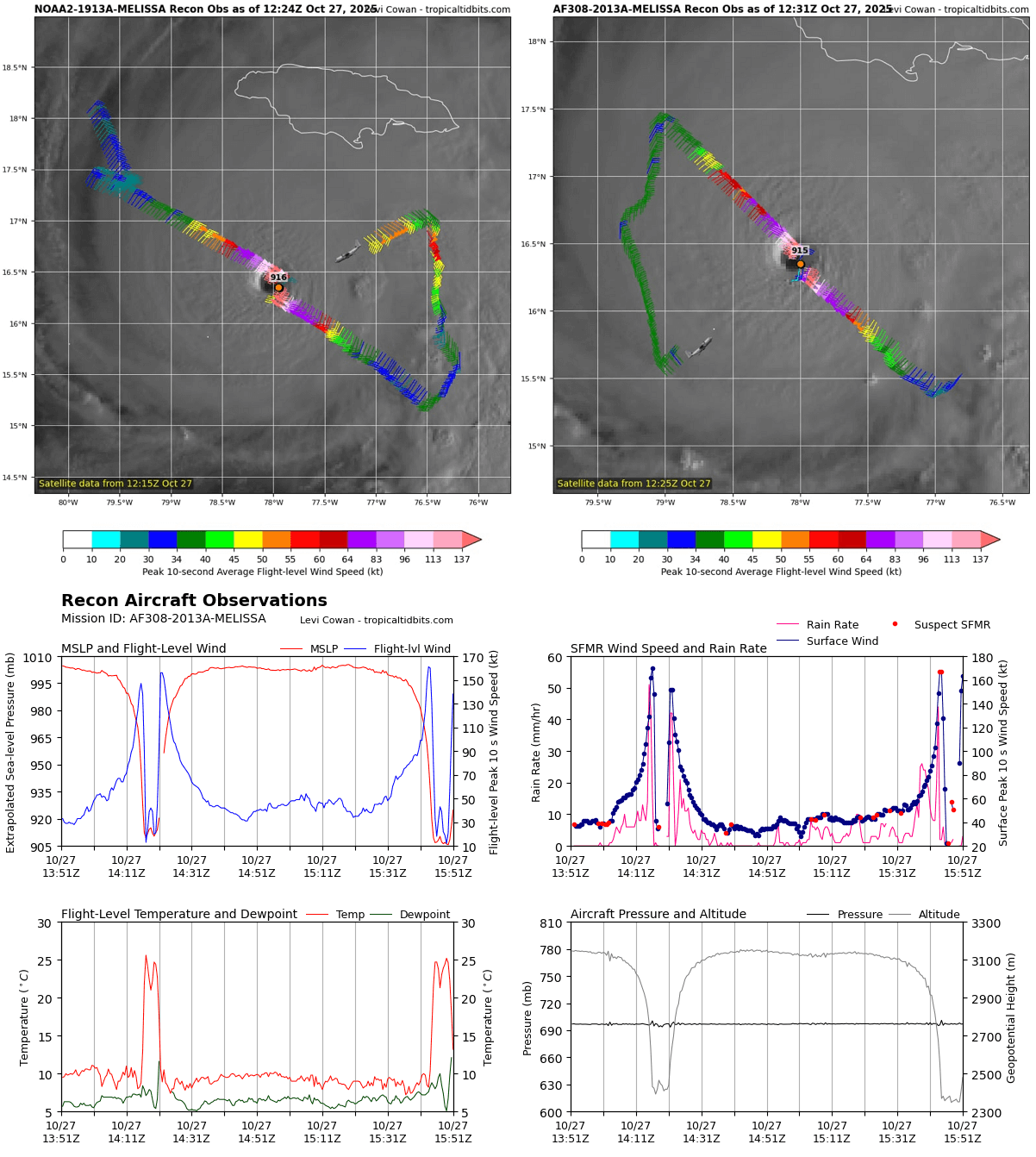
The wind and pressure data cross-section also indicates that Melissa has a perfectly symmetrical structure with only a central, violent inner eyewall and a small eye.
Due to its severity and as a historic hurricane, Melissa’s impact is expected; two aircraft simultaneously scanned the storm on Monday.
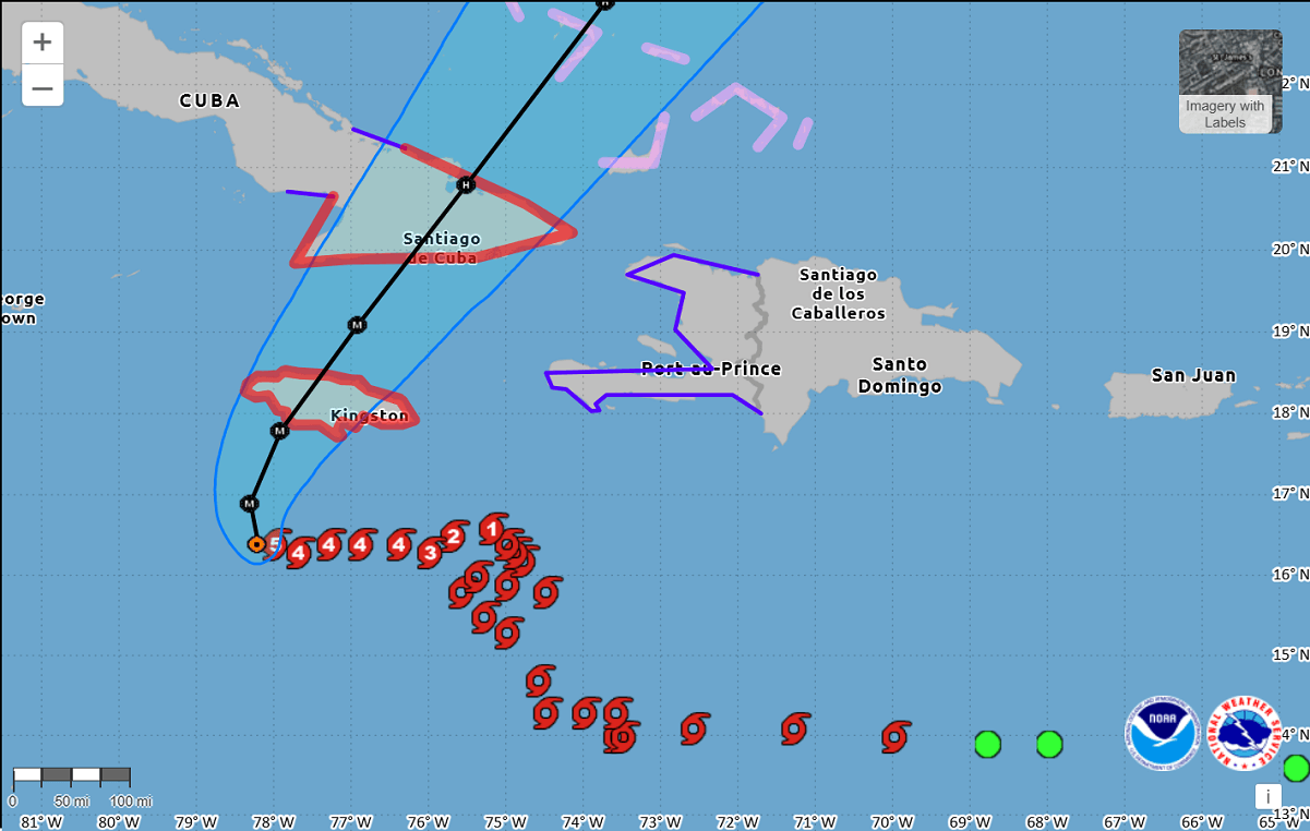
Jamaica faces life-threatening and catastrophic flooding with landslides impacting on Monday night
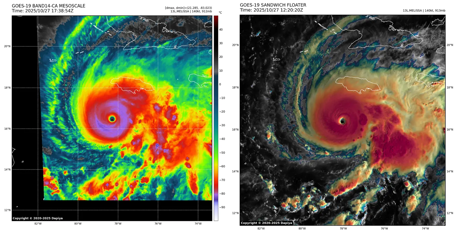
Melissa’s satellite presentation is astonishing. It reveals a fully closed Central Dense Overcast (CDO) with extremely cold cloud tops, reaching near -90 °C. This is a historic Category 5 storm.
A large upper-level outflow remains impressive on the visible and water vapor satellites. This suggests that the environment is near perfection for the most intense hurricanes on Earth, which is strongly conducive to why we have seen such explosive development. Melissa also grew much bigger on Monday.
The eye is wobbling due to the slow motion, but the best initial motion estimate is 270/3 kt. The mid-level ridge north of Melissa is weakening as a deep-layer mid-latitude trough moves eastward through the southeastern United States.
This should cause the hurricane to turn northward during the next 12 h or so at a continued slow forward speed.
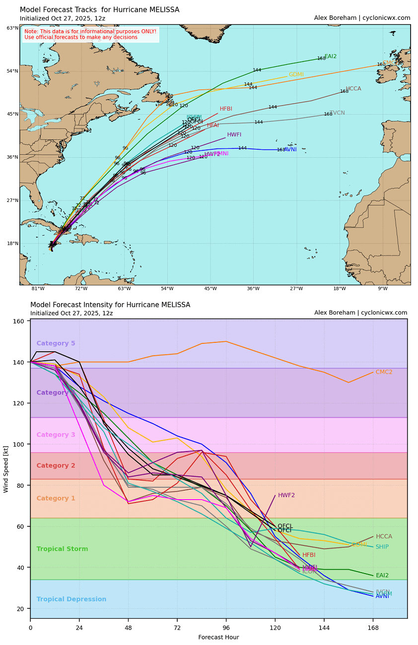
After reaching Jamaica, a combination of land interaction and increasing southwesterly shear should cause some weakening, although Melissa is still forecast to be a major hurricane when it reaches Cuba.
Some fluctuations in intensity are likely during the next 12-24 h due to the possibility that Melissa will start an eyewall replacement cycle. However, this is unlikely to weaken Melissa significantly, and Melissa should remain a monster storm until landfall.
There is no practical difference in Melissa making landfall in Jamaica at category 4 or 5 intensity, since both categories produce catastrophic wind damage.
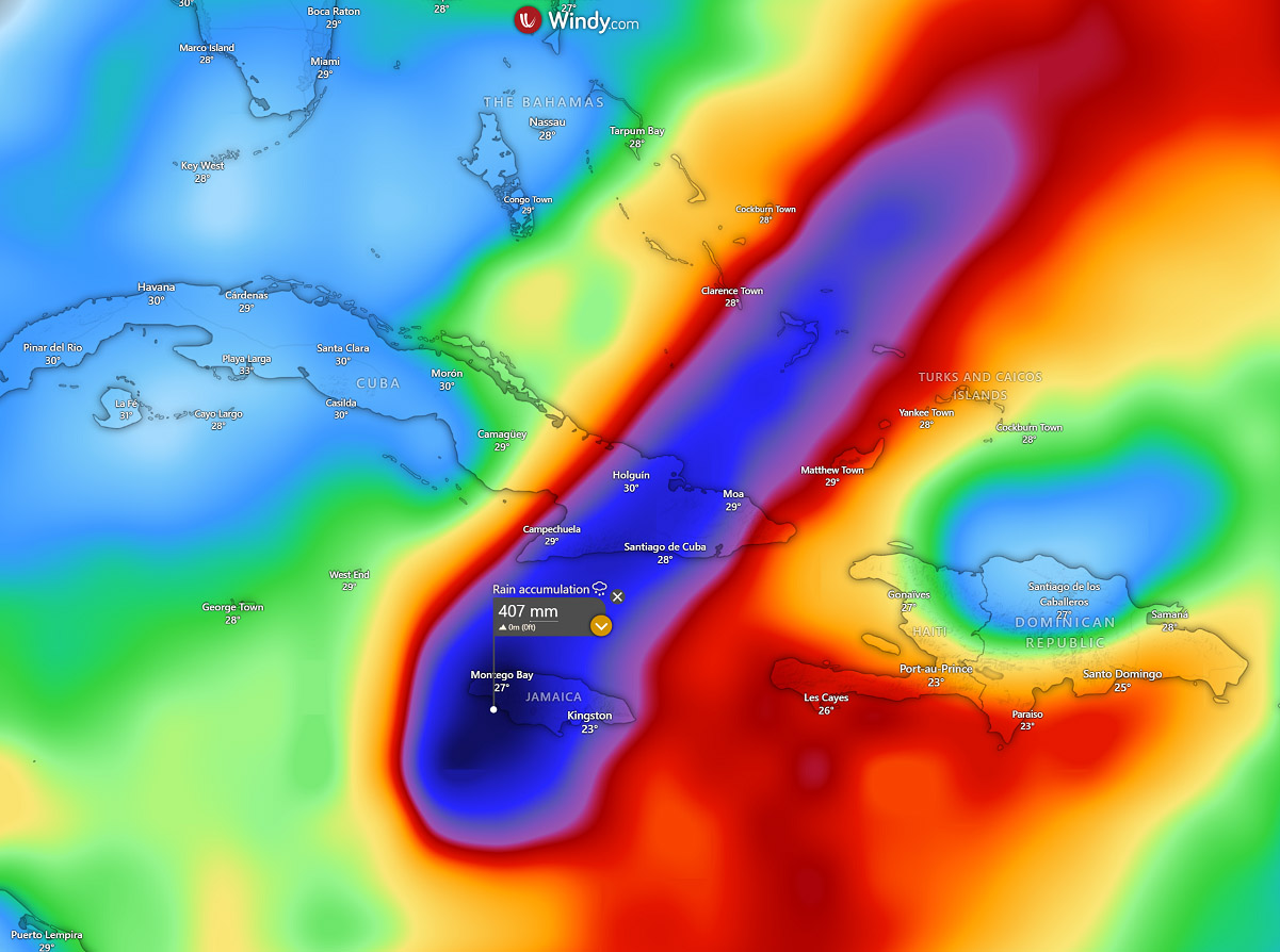
Most weather models suggest that another (13-20″) 350-500 mm of rainfall will be possible along the hurricane’s path. This will result in catastrophic flooding and landslides for Jamaica.
Around 200-250 mm will also be likely across eastern Cuba by Wednesday night as Melissa travels across.
The other concern is the swath of extremely severe winds associated with the vigorous storms inside the eyewall. As Melissa will remain a high-end Category 5 storm, the sustained winds will likely exceed 160 mph (250 km/h) during landfall. This leads to extreme wind damage and life-threatening, non-survivable weather conditions.
After crossing Jamaica, Melissa will move northeast across eastern Cuba while maintaining a solid Category 4 intensity. Therefore, the impact will be extreme, similar to that over Jamaica.
Once Melissa moves over Cuba, it will graze across the Eastern Bahamas, remaining a major hurricane or at least Category 3 strength.
After the Bahamas, hurricane Melissa should continue northeast with some increase in forward speed as the mid-latitude westerly flow becomes the dominant steering mechanism. It should move towards Bermuda late this week, gradually weakening and accelerating with the general southwest flow.
Safety Preparedness during a Hurricane Season
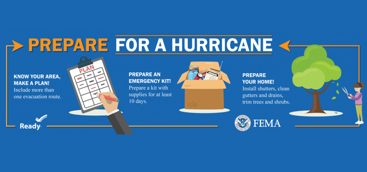
Have a plan
The official hurricane season in the North Atlantic and the Caribbean starts on June 1st and ends on November 30th. This is when you and your family must be prepared by planning.
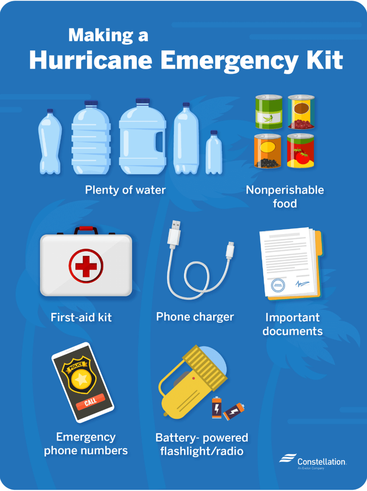
- Write emergency phone numbers and keep them on the refrigerator or near every phone in your house. It would help if you also programmed them into your cell phone.
- Prepare an emergency supply kit.
- Locate the nearest shelter in your area and different routes from your home in an emergency. If shelter locations in your area have yet to be identified, learn how to find them before the event of a storm.
- Pet owners: Take care of your pets at pre-identified shelters, a pet-friendly hotel, or an out-of-town friend or relative where you can take your pets in case of an evacuation. Local animal shelters can offer advice on what to do with your pets if you are asked to evacuate your home during a hurricane.
Learn the difference between a hurricane “Watch” and “Warning”
When you listen to the National Weather Service alerts on TV or radio or check for them online, there are two kinds of alerts:
- A hurricane watch means hurricane conditions (sustained winds of 74 miles per hour [mph] or higher) are possible in a stated area. The National Hurricane Center (NHC) will announce hurricane watches 48 hours before it expects tropical storm-force winds (sustained winds of 39 to 73 mph) to start.
- A hurricane warning is a more severe threat. This means that hurricane-force winds are expected in a stated area. NHC issued these warnings 36 hours before tropical-storm-force winds were expected in the area to give people enough time to prepare for the storm.
Check out the National Weather Service’s Hurricane Center for more information about hurricane watches and warnings. If you hear a hurricane watch or warning in your area, you can take steps to get ready.
Get your car ready to leave home if needed
Make sure your car is ready before the tropical storm or hurricane hits.
- Fill the gas in your car’s tank.
- Move cars and trucks into your garage or under cover.
- Always keep an emergency kit in your car.
If you don’t own a car, consider making plans with friends and family or calling the authorities to get a ride if you need to evacuate.
Get your family and pets ready
- Go over your emergency plan with your family; understand everything.
- Keep checking for weather updates about the storm. You can watch TV, listen to the radio, or check the NHC website online.
- Call the hospital, public health department, or the police about special needs. If you or a loved one is older or disabled and won’t be able to leave quickly, get their advice on what to do.
- Put pets and farm animals in a safe place.
Get your home ready
- Clear your yard to ensure nothing can blow around during the storm and damage your home. Move bikes, lawn furniture, grills, propane tanks, and building materials inside or under the shelter.
- Cover up house windows and doors. Use storm shutters or nail pieces of plywood to the outside window frames to protect your windows. This can help keep you safe from flying debris and pieces of shattered glass.
- Be ready to turn off your power if you see flooding, downed power lines, or have to leave your home. Switch your power off completely.
- If you lose your water supply during the storm, clean containers with drinking water. You can also fill your sinks and bathtubs with water for washing.
- Double-check your carbon monoxide (CO) detector’s battery to prevent CO poisoning.
Be ready to evacuate or stay at home
During a hurricane warning, always listen to authorities regarding whether you should evacuate or stay home.
If a hurricane is coming, you may hear an order from authorities to evacuate (leave your home). Never ignore an order to evacuate. Sturdy, well-built houses may not hold up against a hurricane’s power. Staying home to protect your property is not worth risking your family’s health and safety.
There are occasions when you may hear an order to stay at home. If driving conditions are too dangerous, staying home might be safer than leaving. Respect the authorities’ decisions.
If you need to evacuate:
- Grab your emergency supply kit and only take what you need (cell phone, chargers, medicines, identification like a passport or license, and cash).
- Unplug your appliances. If you have enough time, turn off the gas, electricity, and water.
- Follow the roads emergency workers recommend, even if dense traffic is expected. Other routes might be blocked or already flooded. Never drive through flooded areas, as cars and other vehicles can be swept away or may stall in just 6 inches of moving water.
- Contact your local emergency management office and ask if they offer accommodations for owners and pets.
If you need to stay home:
- Keep your emergency supply kit somewhere you can easily access it anytime.
- Follow weather updates online from NHC, and listen to the radio or TV for updates on the hurricane.
- Stay inside. Even if it looks calm, don’t go outside. Wait until you hear an official message that the hurricane is over. Sometimes, the weather gets calm in the middle of a storm, but then quickly worsens again.
- Stay away from windows. You could get hurt by flying debris, such as pieces of broken glass or other objects picked up by the winds around the neighborhood during the storm. Stay in a room without windows or go inside a closet.
- Be ready to leave home. If emergency authorities order you to leave or your home is severely damaged, you may need to go to a shelter or a neighbor’s house.
Our expert forecaster team will actively follow the tropical region activity worldwide, including Atlantic Basin systems and tropical cyclones likely to affect the United States, the Caribbean, and Europe again in the following months.
NOAA, NHC, Colorado State University, CyclonicWX, and WHO provided images used in this article.
See also: