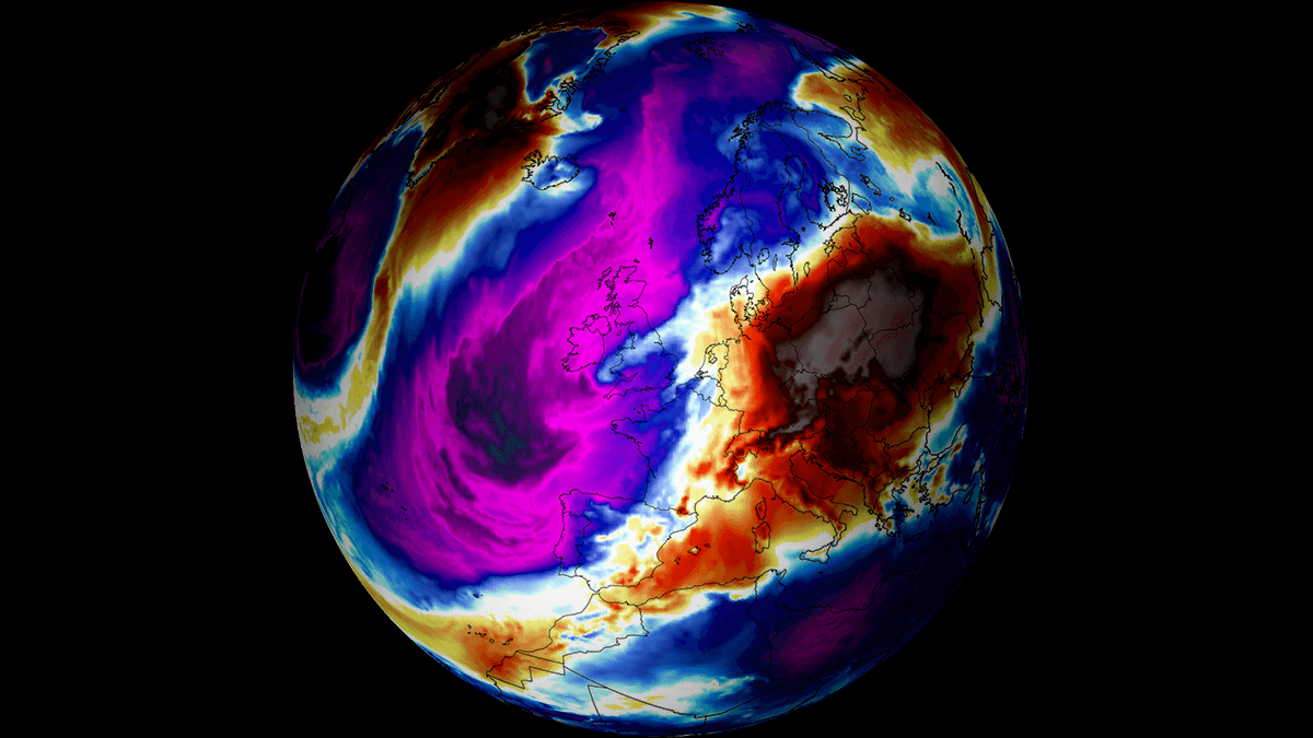
The North Atlantic and Greenland are under an intense blocking High, meaning the warmer zonal flow is weakening towards Europe, and the flow is turning into a northerly direction. Finally, this week, an Arctic cold wave is expected to emerge in the western half of Europe, bringing significantly colder weather and snow. The pattern also triggers a rainy period for the Mediterranean region, with excessive rain and flooding threats in some areas.
After a mild but dynamic week and this weekend, a dramatic temperature change is expected as the new week begins. A strong ridge will maintain over the North Atlantic and Greenland, allowing the flow to deliver a cold, Arctic air mass across western and southwestern Europe.
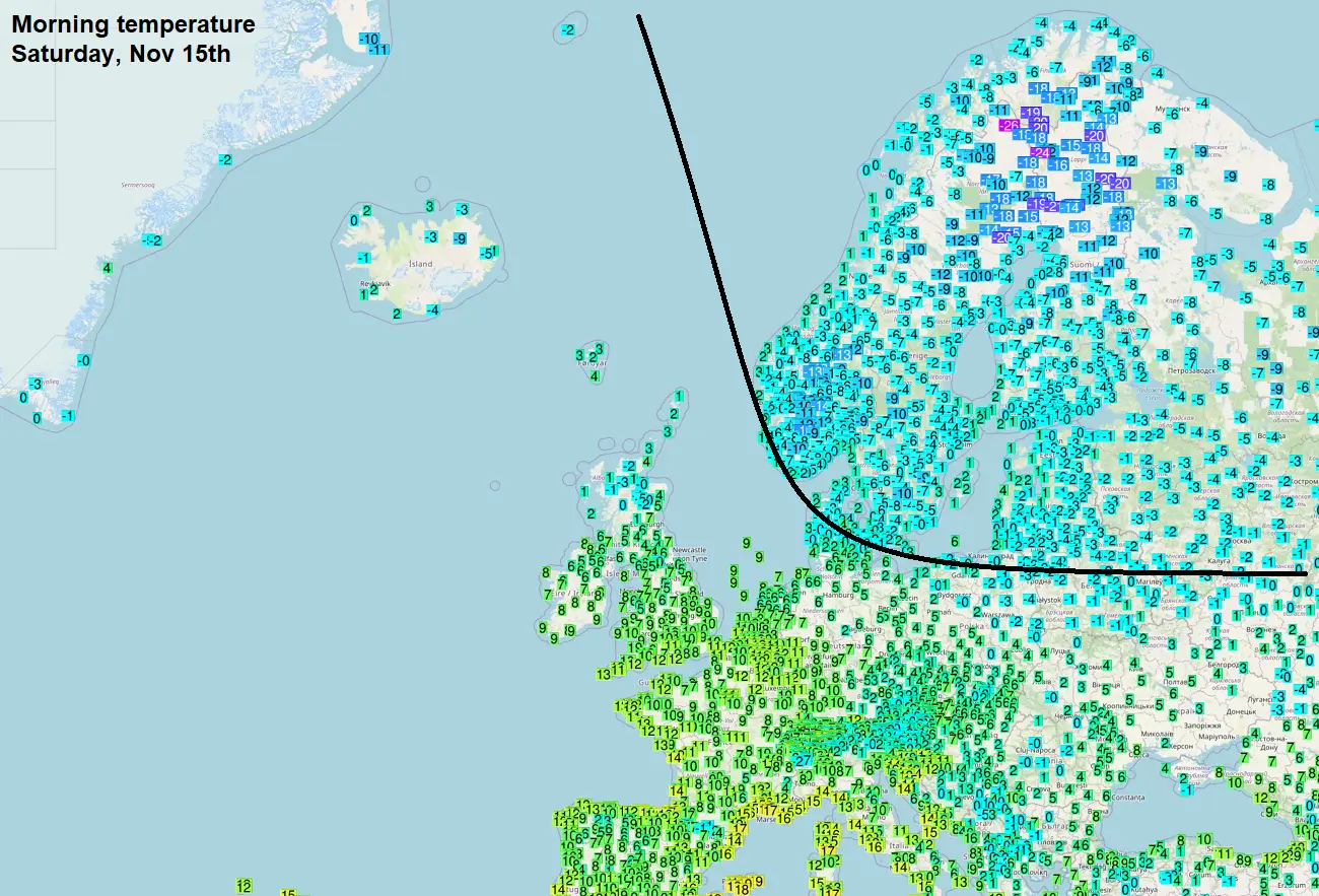
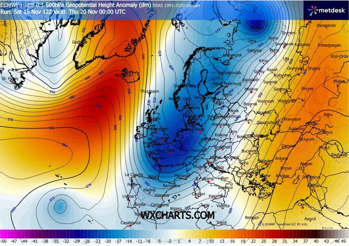
This Saturday, the temperature picture over Europe was influenced by a deep trough/low moving over northern Scandinavia into northwestern Russia, with an Arctic outbreak, heavy snow, and cold along the frontal system.
Colder temperatures have spread across Scandinavia and the Baltic region, while warmer weather has remained over the rest of Europe. According to the morning temperatures, the separation between the cold in the north and the warmth in the south was clearly visible in the analysis.
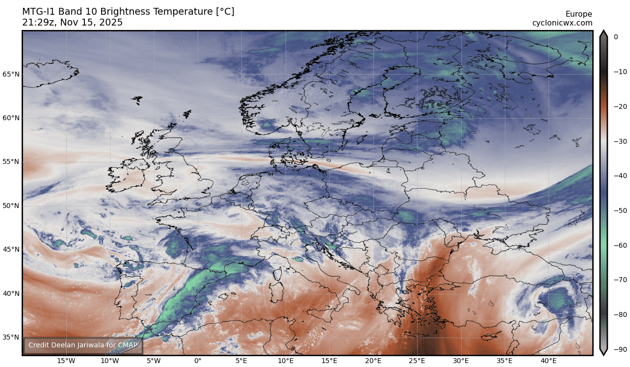
The air masses can also be clearly analyzed on the satellite imagery; the attached image below is the water vapor channel. We can see a colder north and a warmer south, with a large trough featuring a pronounced frontal system over Iberia into the Western Mediterranean.
This wave is gradually moving east on Sunday into Monday, bringing a frontal system with high rainfall amounts to Italy and the western Balkans, as well as deep snow to the Alps. Once this wave shifts further east, it allows the Atlantic High to establish a north-south corridor across Western Europe.
Thus, the corridor remains open, allowing the Arctic air mass to advance far south in the coming days. It also combines with the cold pool over North Europe and gradually spreads into Western Europe early in the week, then continues into Iberia and northwestern Africa by midweek.
Temperatures will be significantly colder than usual for this period across Ireland, the UK, France, Spain, and Portugal from Wednesday through Friday, and from Friday through next Sunday across Morocco, Algeria, and Tunisia.
The following video reveals the progress of this Arctic outbreak over the next 7-10 days.
The extent to which the air mass is colder compared to current temperatures and the long-term average is best illustrated on the meteogram charts. Attached are forecasts for London, UK, and Toulouse, France.
Both reveal that the temperatures at the 850 mbar level (approximately 1,250 meters above sea level) will range from around 7-8 °C above normal to around 5-10 °C below normal. There will be a nearly 20 °C temperature change in just a few days. The wintry conditions are finally here.
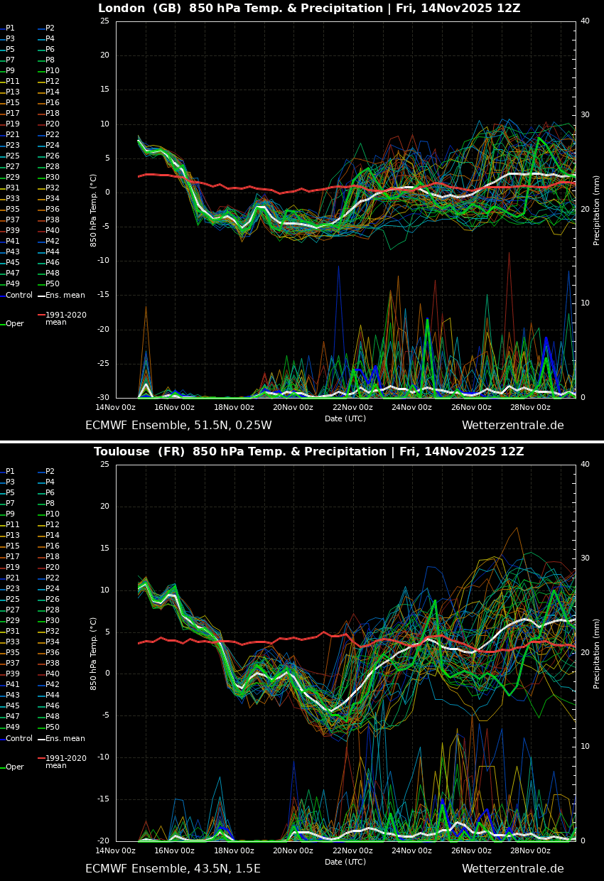
According to these ensemble forecasts, the cold pool is expected to persist until at least the following weekend across Western Europe.
Let’s examine the first details of a pattern evolution that will bring the intense Arctic cold wave in the following week.
Blocking High dominates the North Atlantic with a deep trough grazing into Western Europe
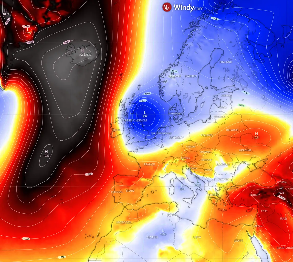
Over the weekend, the weather pattern over the North Atlantic and Europe revealed an extensive blocking high over the North Atlantic and Greenland, with a deep low over Northern Europe. This is gradually establishing a meridional flow between the two.
As the new week starts, the arrival of the Arctic airmass strengthens the trough and expands into Western Europe.
At the surface, a frontal system with a low-pressure system develops over the UK and the North Sea, while the pressure significantly rises over the North Atlantic, beneath the large blocking High.
This results in intensifying the northerly flow, as can be well seen on the pressure chart below. Tight isobars can be analyzed from the deep north towards the south across the Faroe Islands, the UK and Ireland, and continue into the Bay of Biscay.
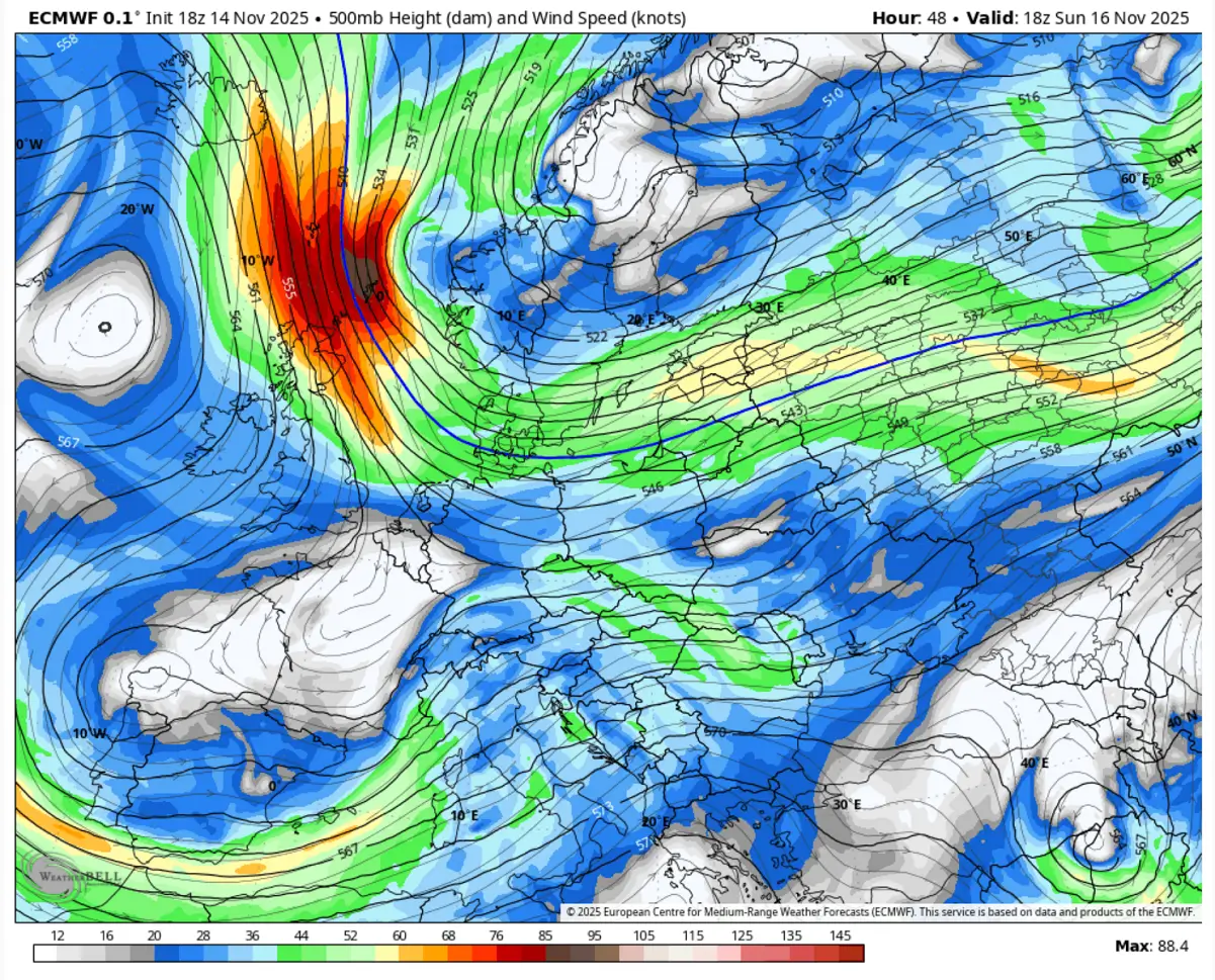
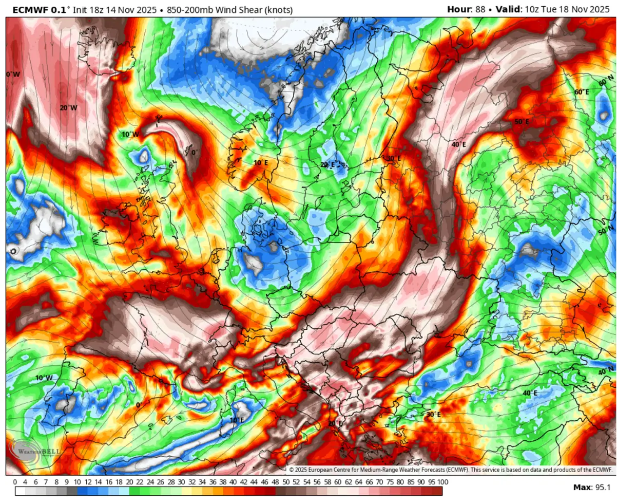
This pressure and temperature gradient between the North Atlantic Ridge and the deep wave over North Europe results in an intense jet stream towards Western Europe.
Violent winds will occur at higher altitudes, near 100 knots at the 500 mbar level. This is also why the advancing cold will be easily pushed southward; there is nothing to stop or divert it anymore.
By Monday, the cold air mass reaches central France and Germany, as the northerly flow accelerates its spread towards the south. The low over Scandinavia also helps to tighten the pressure gradient towards the Atlantic, allowing for a clear and undisturbed path into Western Europe.
Further east, over Eastern Europe and the Balkans, the southwesterly flow maintains unusually warm temperatures with local temperatures above 20 °C.
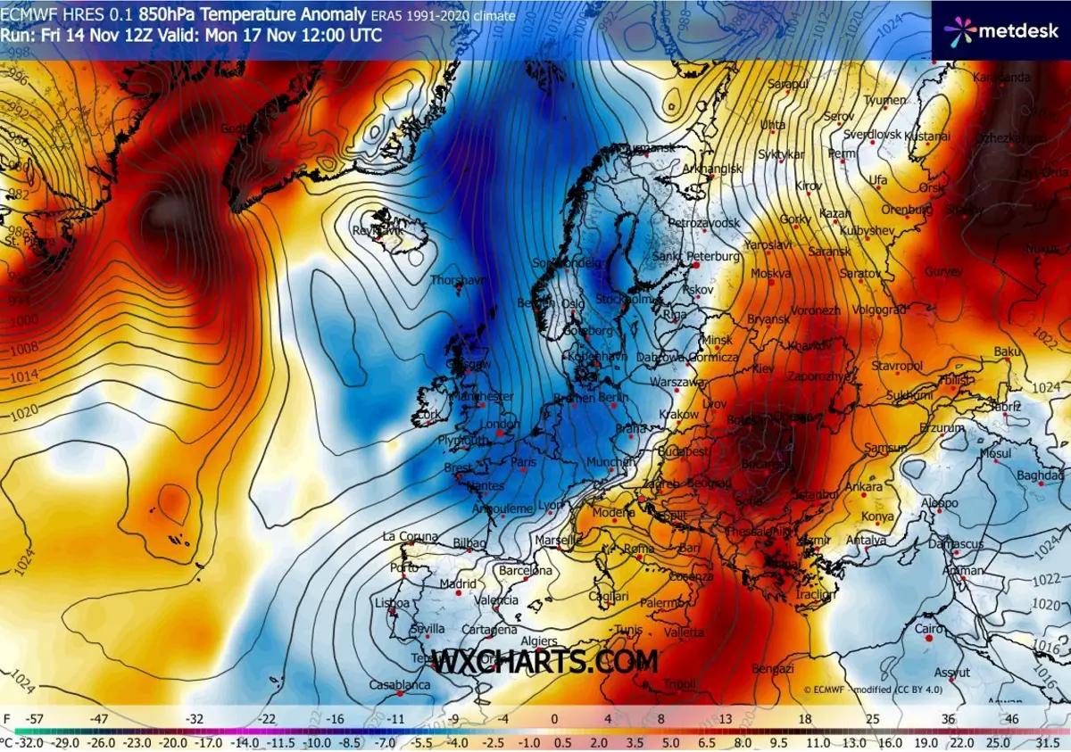
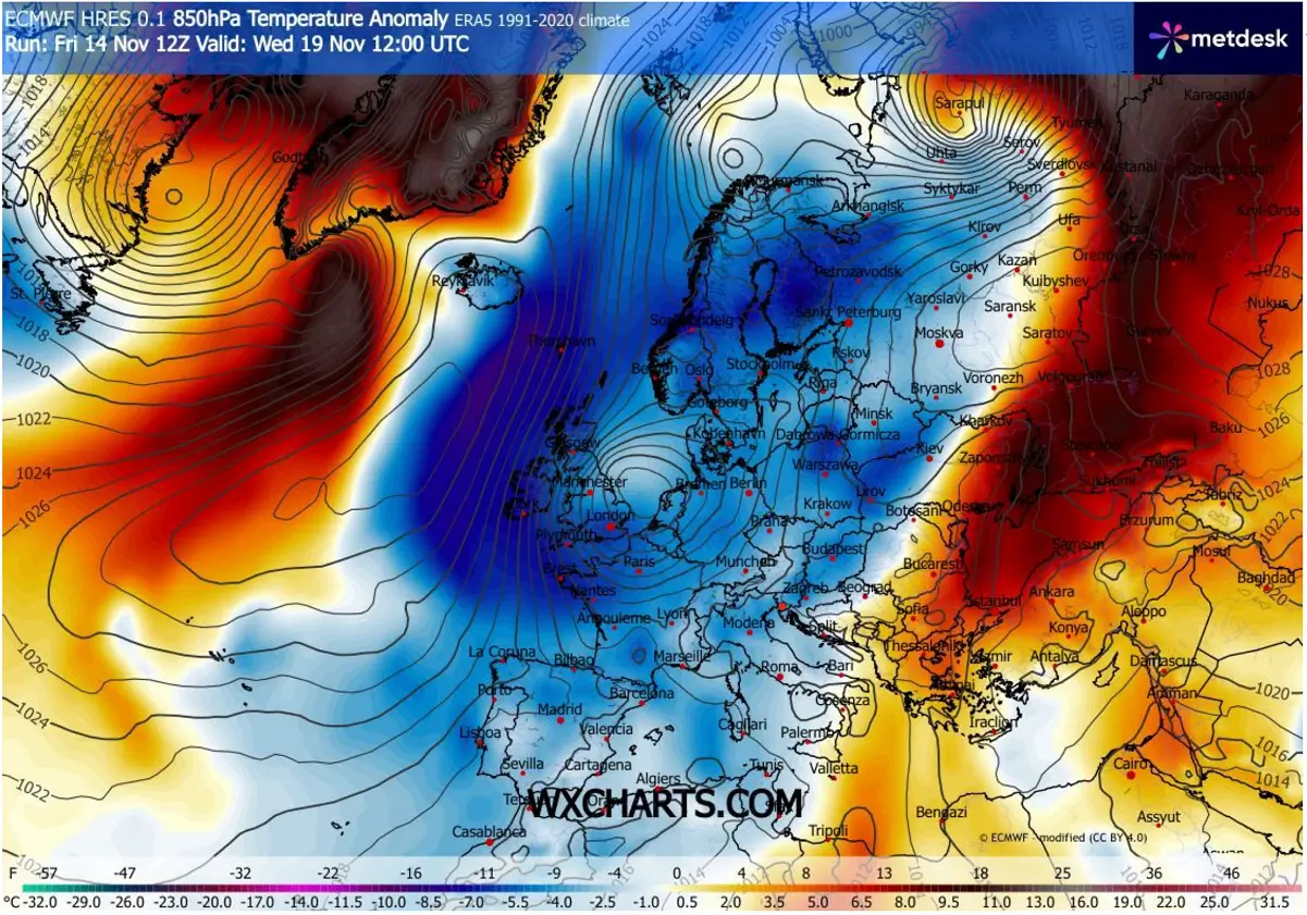
Through mid-week, the Arctic cold intensifies as it gets dragged over Western Europe, with the core of the cold pool around 10-12 °C more frigid than usual as it travels over the UK and Ireland towards the Bay of Biscay.
We can also see that the colder air mass spreads into the Mediterranean, central Europe, and flushes away the warmth from the Balkans and Eastern Europe. But the most intense cold remains in the western part of Europe.
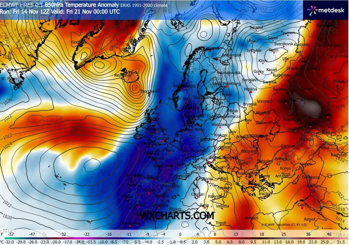
Later in the week, the North Atlantic High gradually shifts south towards the Azores, allowing Arctic cold to reach the Iberian Peninsula, with Spain and Portugal experiencing the strongest cold.
The cold also reaches the Western Mediterranean, Morocco, and western Algeria.
Examining the 2m temperature anomaly on Thursday night, Europe is divided into two distinct halves. The West is cold, while the East remains relatively warmer than usual despite the colder mid-levels spreading east by mid-week.
Next, we will check the daily lows in the most targeted regions, as some decent cold is forecast this coming week.

Combined with some precipitation during the progression of the Arctic front, some snow is also forecast. While lacking some well-defined secondary frontal systems, the most concentrated areas for snow accumulation will be the northern slopes of the mountain ranges.
This means the Scottish Highlands in the UK, the Pyrenees, and the Alps. A significant amount of snow is also forecast for western and southwestern Norway, as a moist and cold air mass from the Norwegian Sea delivers heavy orographic snowfall.
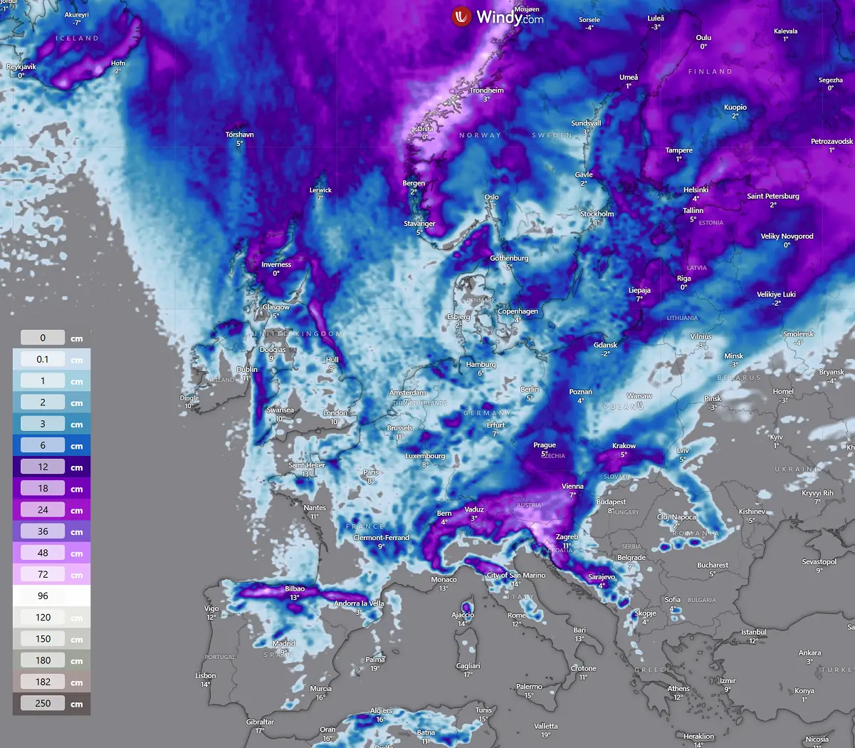
Note that there is also a snow forecast for higher terrain in central Spain, as well as for northern Algeria, the Apennines, and the western Balkans. Only occasional snow is expected in most lowlands, with no significant accumulations.
The coldest air mass of the season so far for Western, Central, and Southwestern Europe is forecast
As we discussed earlier, the cold air mass will take its place in Western Europe after Monday, then gradually spread south and east over time.
Depending on the winds and clear skies, the cold mornings will vary from region to region during the week.
Ireland and the UK
The coldest days over the UK and Ireland are forecast to be from Wednesday through Friday, related to the deepest cold core aloft. Since the winds often limit the significant cold in Western Europe, the colder the mid-levels, the lower the temperatures, essentially compensating for the lack of wind at nighttime.
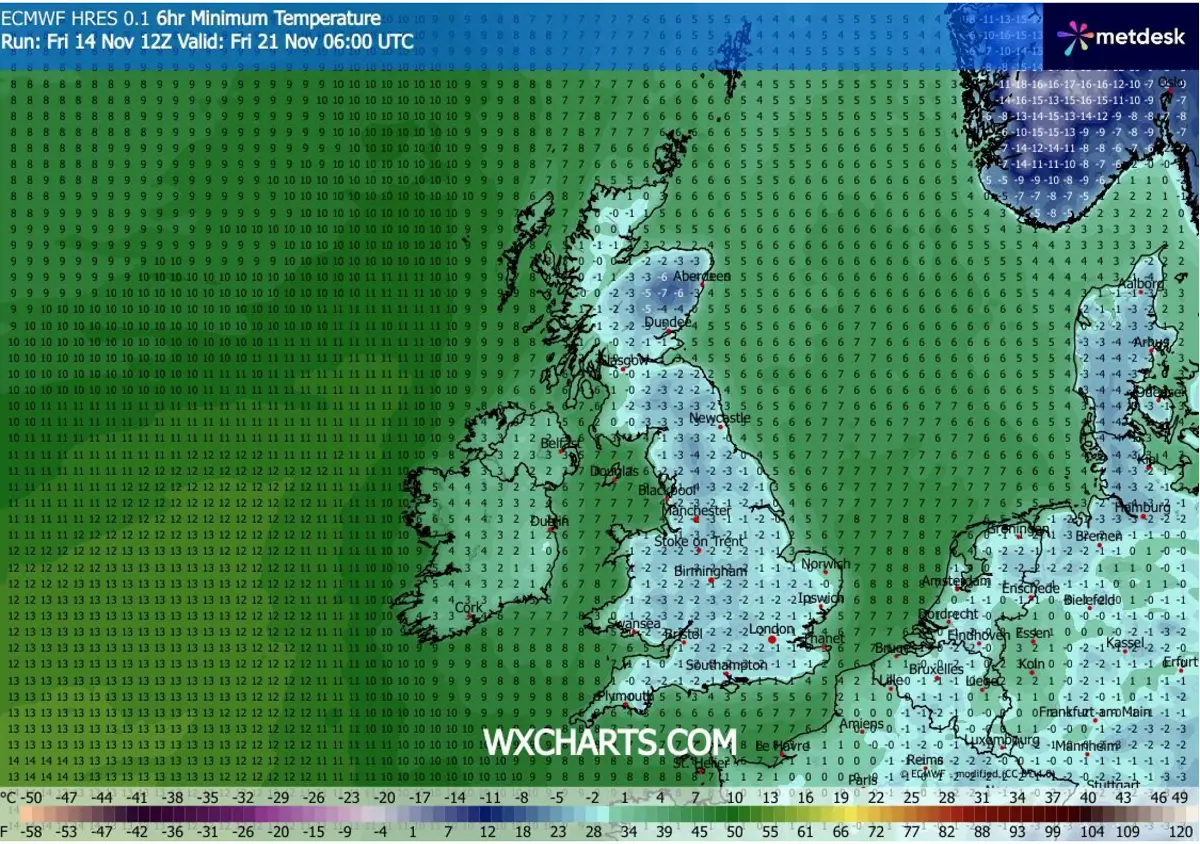
Both Thursday and Friday are expected to bring below-freezing temperatures across the UK and Wales, with the lowest temperatures ranging from -3 to -5 °C in the lowlands and even lower in higher elevations. Parts of Ireland and Northern Ireland are also expected to reach around 0 °C on Friday.
France, Spain, and Portugal
The temperatures over France, Spain, and Portugal are expected to remain stable from Tuesday through Thursday, with the morning lows reaching from 0 to -3 °C in a large part of France.
Over Spain, the morning temperatures on Wednesday are forecast to reach from -2 to 5 °C in some areas, with only the southwestern part remaining around 5 °C. That is pretty low for mid-November.
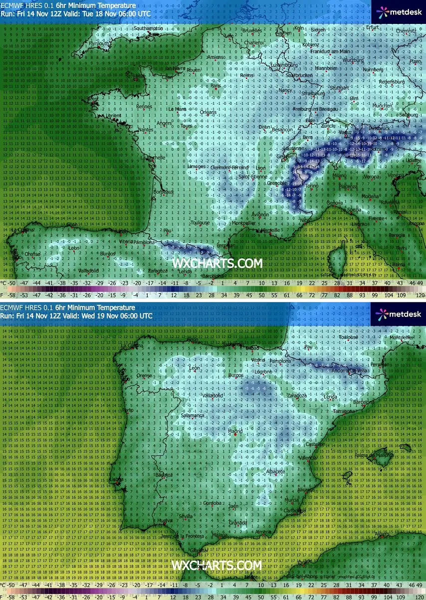
Northern Portugal is expected to see morning lows near 0°C on Wednesday, while the southern parts are forecast to experience temperatures ranging from 5 °C to 10 °C.
Germany, Poland, Czechia, the Alps, the north Balkans, and Italy
Central Europe is forecast to see the lowest temperatures by mid-week, with the coldest in the Alpine region. Elevated terrain and Alpine valleys will see temperatures below -10 °C.
Central and South Germany, Czechia, Slovakia, southern Poland, Slovenia, and western Hungary are expected to experience morning lows ranging from -3 to -7 °C.
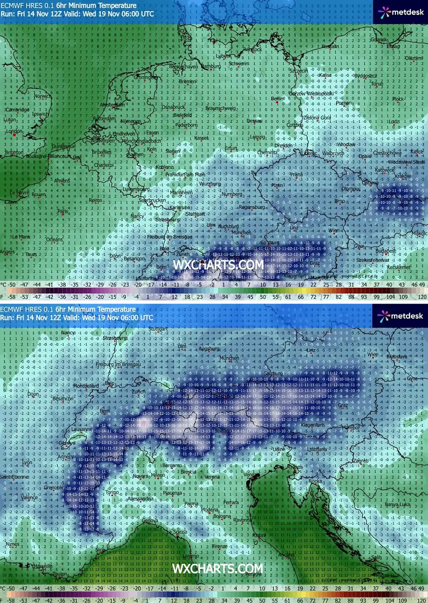
Northern Italy is expected to experience temperatures near or slightly below 0 °C on Wednesday. Western Balkan countries should also experience temperatures below freezing.
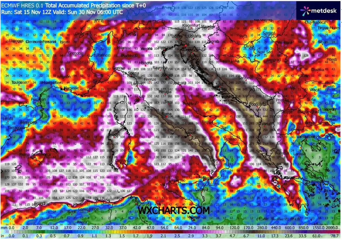
Deep cold wave in the West triggers a persistent southwest flow over the Mediterranean region
Strong winds always result when a tight pressure and temperature gradient is present. Thanks to a large and deep low on the west, the powerful jet stream will also support strong wind shear along the eastward progressing frontal systems from the Mediterranean region into the Balkans this week.
This means that the large-scale lifting mechanism will occur, producing widespread frontal activity with high precipitation and thunderstorms.
Southwesterly flow over the still warmer-than-normal Mediterranean will help to maintain the warm air mass for the whole week, along with high moisture. Supporting both the excessive rainfall threat and thunderstorm activity.
Warm and moist air increases potential convective energy across the Mediterranean region, especially from the Ligurian Sea to the Tyrrhenian Sea, and over the Adriatic and the Ionian Seas.
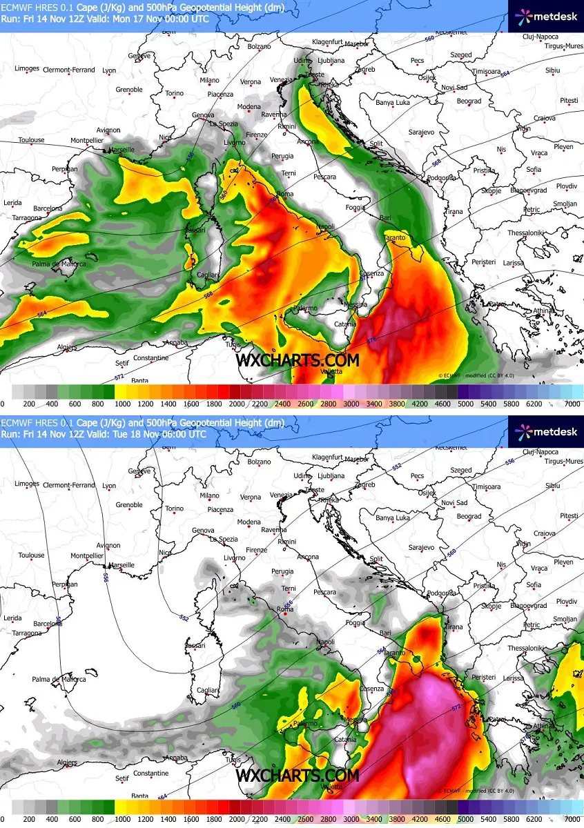
On Monday and Tuesday, high instability will support widespread severe weather over the region. Severe thunderstorms are capable of producing large hail, severe winds, tornadoes, and torrential rainfall. Especially across central and southern Italy, Malta, and along the southwestern Balkans to western Greece.
An intense and persistent southwesterly flow will support excessive rainfall, accompanied by intense orographic rain, along the western Apennines and Dinaric mountains in the western Balkans. Activity will also be combined with thunderstorms.
This is where the maximum precipitation is forecast, likely to bring 300-500 mm of rain in five days in some areas, from Monday through next Saturday.
In addition, convective lines will comprise the training cells effect, combined with orographic rainfall from persistent southwestern winds, and increase rainfall sums locally.
Montenegro and northern Albania are expected to experience extreme rainfall, with locally possible accumulations of more than 700 mm, potentially lasting until the following weekend. This results from several frontal waves crossing the Mediterranean region.
We are closely monitoring the evolution of the changing patterns as they shift back toward more progressive ones, as we approach the end of November. Forecast updates will be required in the coming days if they indicate a higher potential for severe weather.
Windy, WeatherBell, and WXcharts provided the images used in this article.
See also: