Updated forecast: Weather models have shifted into a markedly more wintry mode as the New Year arrived, with a powerful Arctic outbreak now set to engulf nearly two-thirds of Europe. Triggering multiple winter storms from the Mediterranean into the Balkans with blizzards, deep snow, and frigid cold in its wake. Meanwhile, the Arctic air surges as far south as North Africa, bringing snow to parts of Spain and Algeria.
A few Key Highlights of the weather pattern through mid-January 2026:
Arctic Blast: Temperatures are forecast to plunge 12-15 °C below seasonal averages across Central, Western, and Southwestern Europe.
Mediterranean Cyclones Trigger “Balkan Snow Bombs”: Deep low-pressure systems tap into abundant southern moisture, bringing intense snowfall with blizzards over the Balkans and Eastern Europe.
Stratospheric Influence: Another Stratospheric Warming event is further destabilizing the Polar Vortex, increasing the high potential of “locked-in” cold through mid to late January.
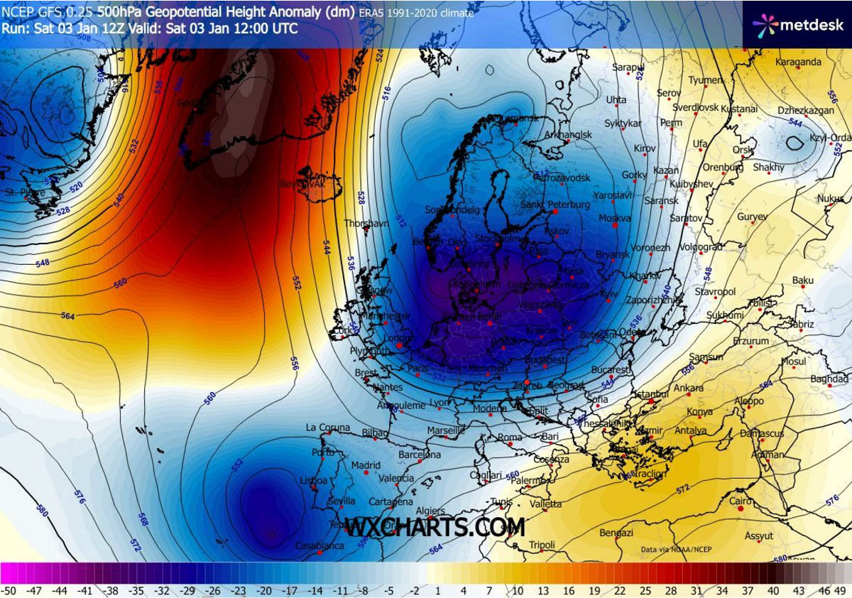
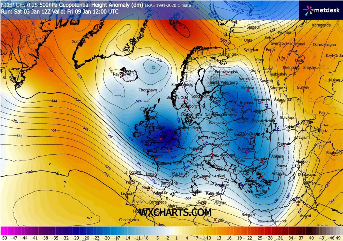
As the New Year began, the atmospheric configuration over the North Atlantic and Europe underwent a fundamental transformation. The previously progressive flow has been abruptly replaced by a classic high-latitude “Greenland Block.”
This expansive ridge of high pressure acts as a meteorological dam, forcing a deep reservoir of Arctic air to spill southward across Europe. The result is a sustained disruption of the Polar Vortex, setting the stage for an extended period of winter weather dominance across the continent.
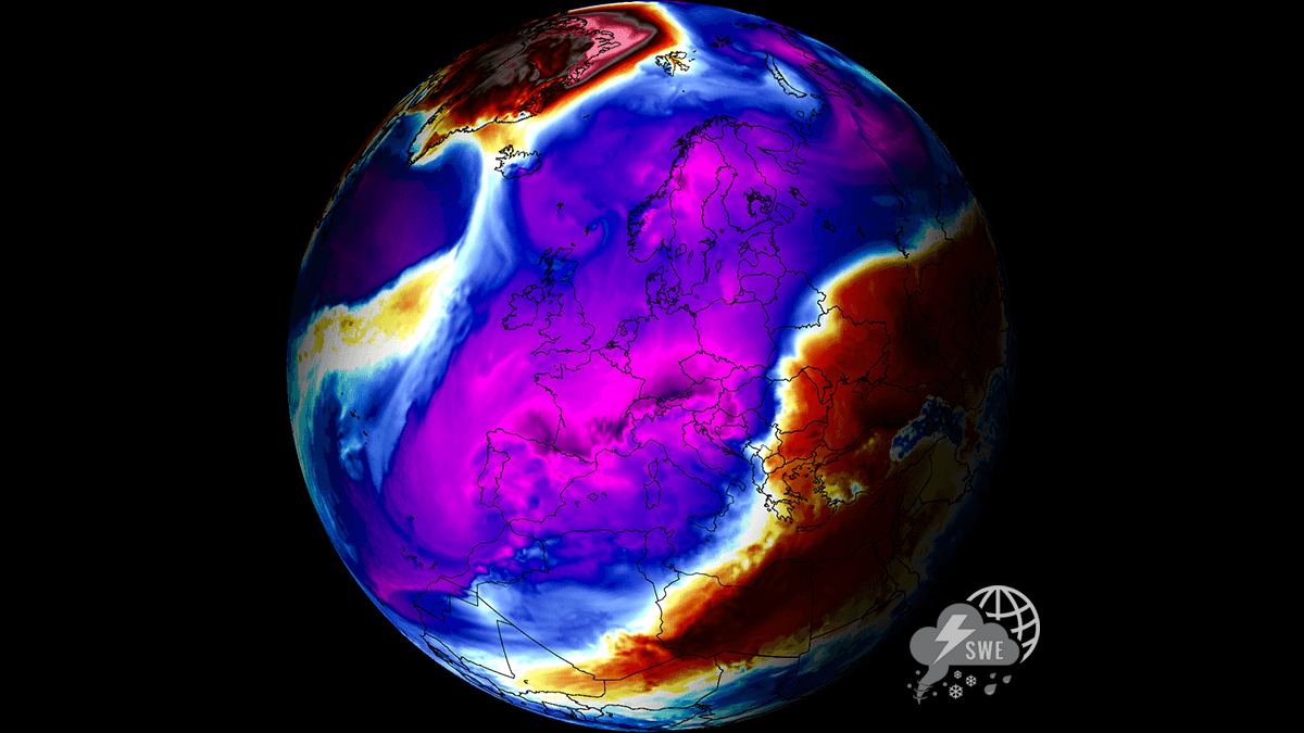
The following satellite image reveals this weekend’s air masses spread across the European continent, showing a large Arctic cold pool on its way into the western half of Europe.
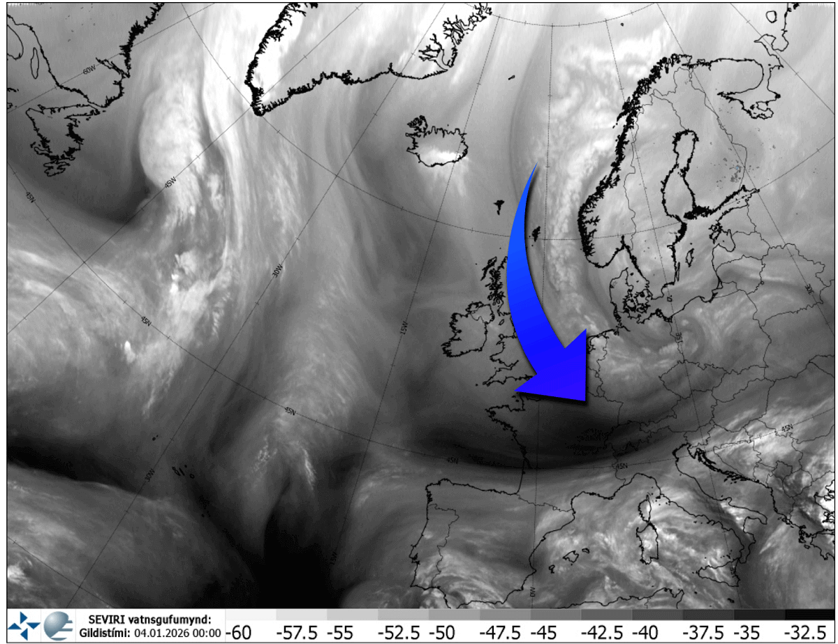
The primary concern now focuses on the ‘clash of the masses.’ As this frigid Arctic air collides with the Mediterranean Sea’s lingering warmth and high moisture content, it will trigger a series of intense secondary cyclogenesis events.
These powerful winter storms are projected to track across the Balkan Peninsula and into Central and Eastern Europe, bringing the threat of deep snow accumulations, whiteout blizzards, and severe travel disruptions.
Further west, latest trends suggest a secondary, deep-layer Atlantic winter storm will blast across Western Europe late next week into the weekend, potentially delivering snow to sea level in areas that started the season unusually mild.
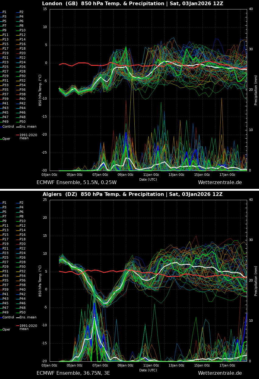
Just by looking over the trends on meteogram charts for Western Europe, we can see the mid-range period ahead will be influenced by the Arctic cold reservoir. Attached are the charts for London, UK, and Algiers, Algeria.
While London is currently at the core of the cold pool, hints of more dynamic weather, including winter storms, are expected over the following weekend. Algiers, on the other hand, reveals a massive Arctic blast arrives mid-next week, with potential for snowfall in the higher terrain in the north and likely severe thunderstorms with heavy flooding rain as well.
As we have discussed in our weather coverage over the past weeks, these conditions have been ongoing since Christmas. They are now extending the progressive, dynamic weather pattern over Europe into January, resulting from the early disruption and split of the Polar Vortex at the beginning of December.
To fully understand the dynamics behind its split, let’s dig into the details of the Polar Vortex and why it is essential to monitor its behavior during the winter season.
What is the Polar Vortex?
The Earth’s atmosphere has six layers. Most of the dynamics for our daily weather occur in the lowest two layers, known as the troposphere and the stratosphere.
The troposphere is the layer closest to the Earth’s surface. It is about 12 km deep and extends from the ground up high into the sky. Depending on where you live, its depth varies from around 8 km to almost 20 km. The troposphere is deepest over the equatorial region and becomes much thinner over the North and South poles.
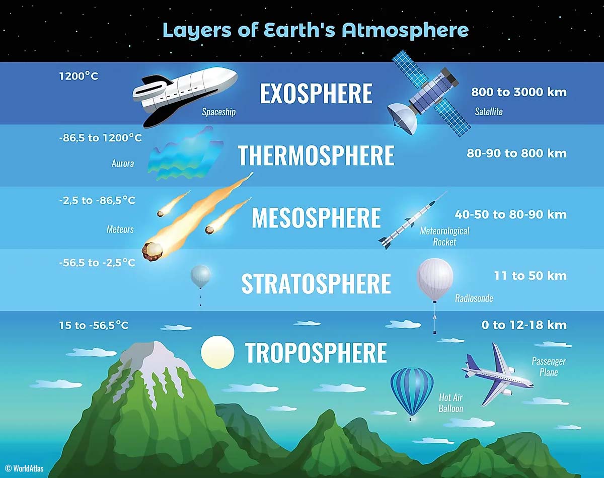
Above this layer is a much deeper one known as the Stratosphere, an 11-50 km thick layer of arid air. Another essential feature in the stratosphere, which makes our weather even more variable, often triggers significant, large-scale, long-lasting winter weather events.
This is the Polar Vortex—an enormous, tri-dimensional ring of powerful winds moving through the sky above us. The Polar Vortex is spinning around the North Pole, grazing through the air at about 20-50 km above the Earth’s surface with violent wind speeds.
How and when does the Polar Vortex form?
Due to the Earth’s inclination, the polar regions receive much less energy from the Sun during the fall months. This makes the cooling over the northern areas more robust. As a result, polar nights can last several consecutive months, followed by days without sunlight.
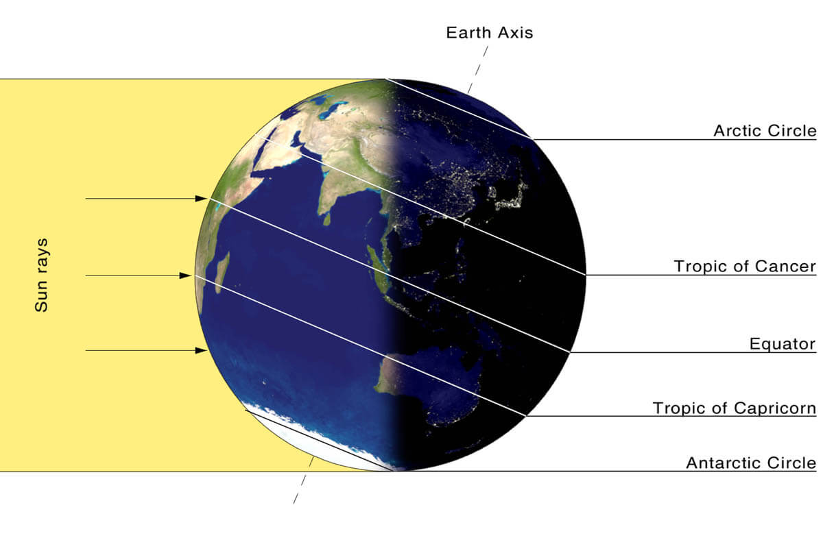
While temperatures in the polar regions are dropping into a deep freeze, the atmospheric layers farther to the south are still relatively warm because they receive more of the Sun’s energy at the same time. Therefore, the south’s equatorial layers remain much warmer than the areas farther north, leading to a high-temperature contrast.
Cooling the polar regions also lowers the ambient surface pressure, and a similar weather process occurs in the stratosphere. The temperature difference between the North Pole and the equatorial areas increases across both layers.
This creates a large, low-pressure cyclonic circulation across the polar stratosphere, where it takes its famous name—the Polar Vortex.
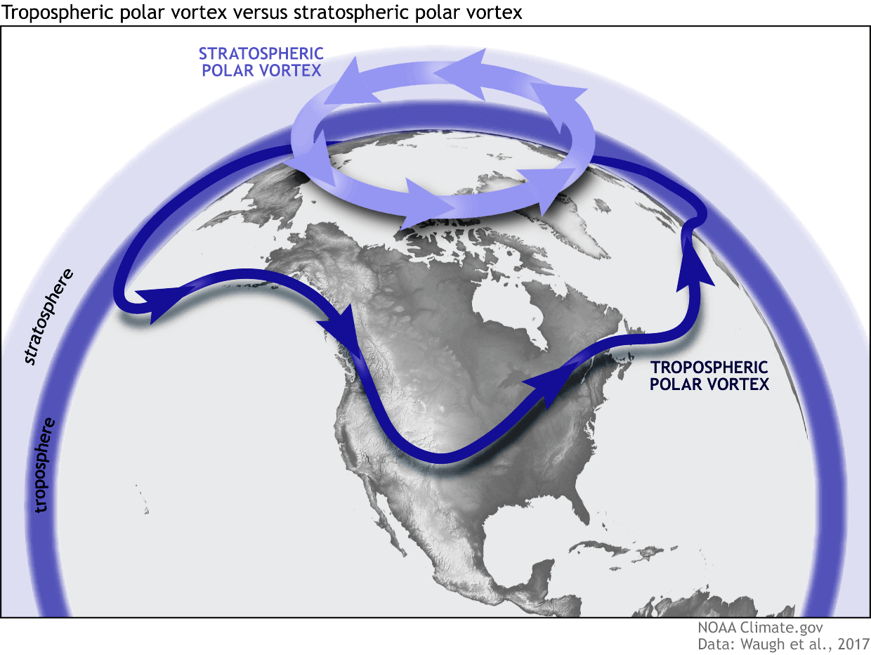
As shown in the image above, we monitor two atmospheric layers during wintertime: the troposphere and the stratosphere. The first is the lowest layer, and the second is at a higher altitude. The Polar Vortex rises through both layers, but with different strengths, shapes, and impacts.
For this reason, we separate the entire Polar Vortex into an upper (stratospheric) and a lower (tropospheric) part. When the Polar Vortex is strong, it traps colder air in the polar regions, preventing its escape and creating milder conditions for most of the United States, Europe, and other mid-latitudes.
But when the Polar Vortex gets disrupted or even entirely collapses, it can’t fully contain the cold air, which can now easily escape from the polar regions into the United States or other mid-latitude regions. Below is an example of how a disrupted Polar Vortex brings cold polar air into the United States and Europe.
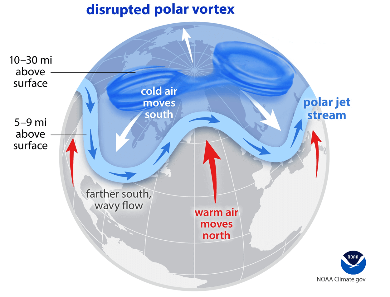
We have experienced this in Asia, Canada, the U.S., and sometimes Europe in recent years. The vortex aloft has been significantly disrupted this winter, and when its lobe shifts on the other side of the northern hemisphere, the extreme cold grips the North American or European continent.
The disruption of the Polar Vortex and its split at the start of the meteorological Winter season of 2025/26 were the primary triggers of the frigid cold outbreaks in Siberia, Alaska, and Yukon, with temperatures reaching nearly -75 °F (-60 °C) this month. It is now Europe’s turn.
The Greenland Block Restructures the Weather Pattern and Returns Cold Temperatures over Europe
A massive ridge of high pressure has expanded over Greenland and the North Atlantic. As a result, the jet stream is forced into a highly meridional flow, creating a corridor for Polar air to move directly from the Arctic Circle toward the Mediterranean.
In response to the Greenland blocking, a deep trough with a large surface low-pressure system is racing south through Western and Central Europe. Deep snow and frigid cold to -40 °C have spread across Northern Europe in its wake.
The surface analysis over Europe indicates a significant deep low (987 hPa) centered over the Baltic Sea, affecting much of Northern and Eastern Europe. It is resulting in intense sea-effect snowfall and blizzards in southern Sweden, Lithuania, and Latvia. It is also dragging extreme, frigid cold across Scandinavia.
A similar deep snow is also gradually developing for Denmark in the coming days, with 30-50cm possible across most of the country.
Another 991 mbar surface low is situated off the coast of Portugal and Morocco, bringing high moisture into the Mediterranean region.
Southeast Europe, with Turkey, and the far North Atlantic, with Greenland, are blocked by a strong ridge, trapping the corridor for low geopotentials across continental Europe.
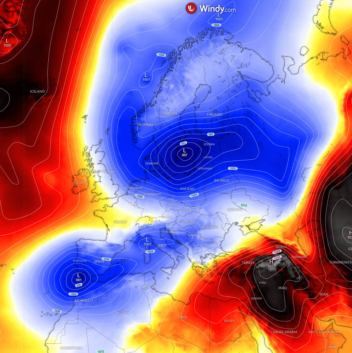
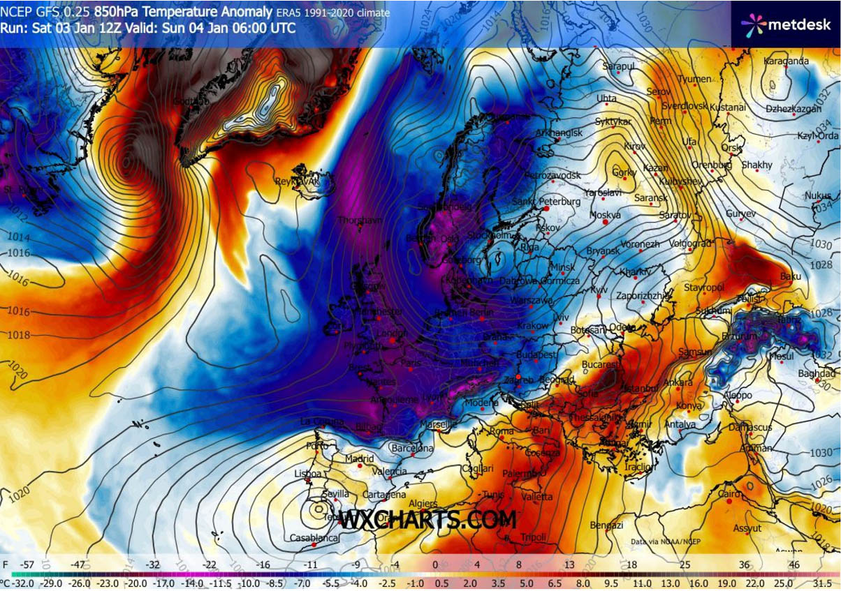
As a result, a huge Arctic cold reservoir is plunging across Northern and Western Europe towards the south, engulfing Scandinavia, Denmark, the Faroes, the UK, Ireland, Benelux, and France into significantly colder air masses.
The cold pool is spreading south this Sunday and will reach the Western Mediterranean Sunday night.
Ahead of the deep trough digging south, a warm plume advects warmer air from the Mediterranean into the southern and central portions of the Balkan peninsula.
The Arctic Plunge into the Mediterranean Triggers Major Winter Snow Storms in the Balkans
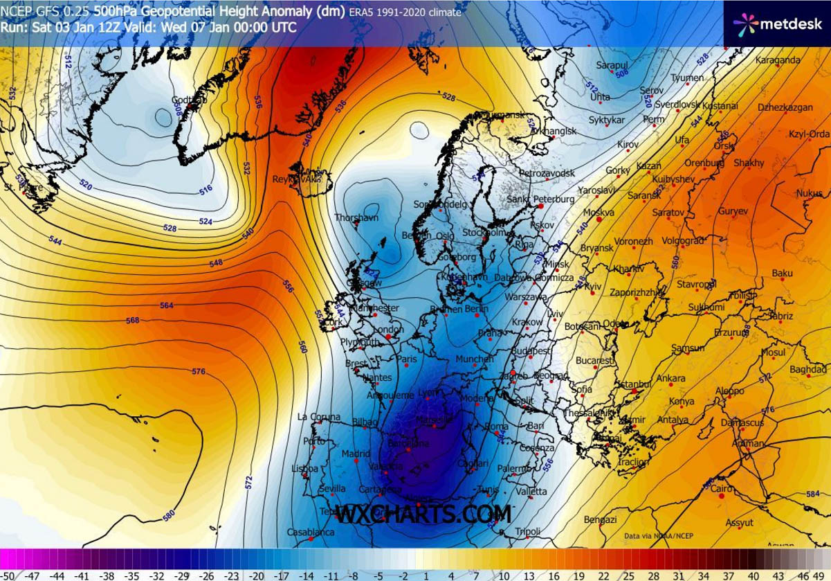
As the new week arrives, the core of the deep upper-level trough over Western Europe digs far south, reaching the Western Mediterranean.
Locked between the Azores High and the southeast European ridge, the trough slows down and deepens over the warmer Mediterranean environment.
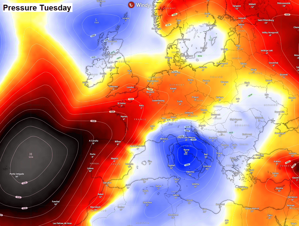
This pattern is also very well reflected on the surface chart on Tuesday. It reveals a strong high-pressure system over the Azores that is expanding into the Iberian Peninsula, while the trough aloft triggers surface cyclogenesis over the central Mediterranean.
This low deepens Tuesday night considerably as it travels across Italy into the Adriatic Sea, maturing as it reaches the north-central Balkans. As a result, both temperature and pressure gradients increase over the region.
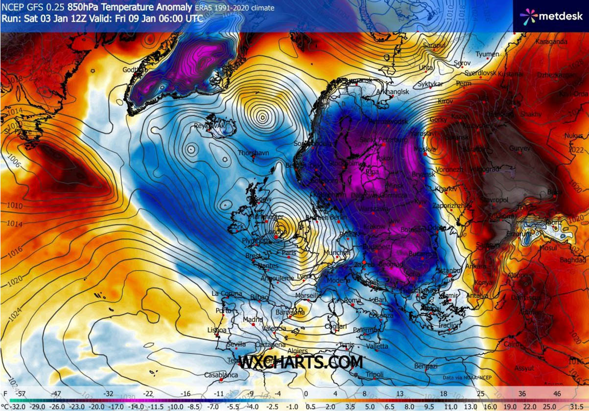
The core of the Arctic cold air reservoir is therefore dragged even further south on Tuesday, engulfing Central Europe, France, Spain, Portugal, and the Western Mediterranean in temperatures nearly 15 °C below normal. Significantly colder air mass also reaches Morocco and Algeria.
The cold pool also gradually advances eastward into the north-central Mediterranean and the Northern Balkans. At the same time, the warmer air mass remains over the southern Balkans, the Black Sea region, and Turkey.
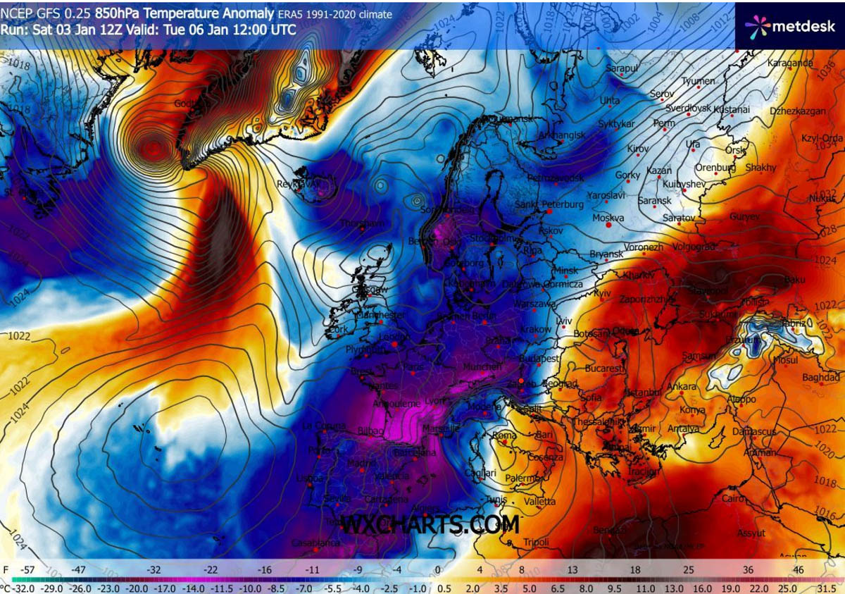
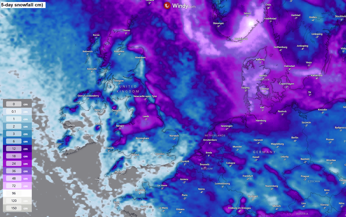
The clash of Arctic air masses with the warmer, moist Mediterranean air mass will result in heavy snowfall across Central Europe and the Balkans as several Winter Storms move across from Tuesday through Friday.
The most intense and widespread snowfall, combined with blizzards and whiteout conditions, is expected across the Central Balkans, including Bosnia, Croatia, northern Serbia, southern Slovenia, southern Hungary, north of Romania, and most of Ukraine.
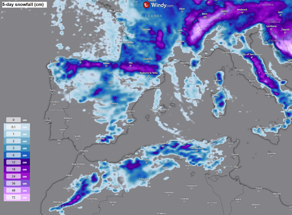
Locally, snow accumulations will exceed 50 cm, possibly close to 100 cm, over western Bosnia and northern Romania. Deep snow is also forecast for the Western Alps.
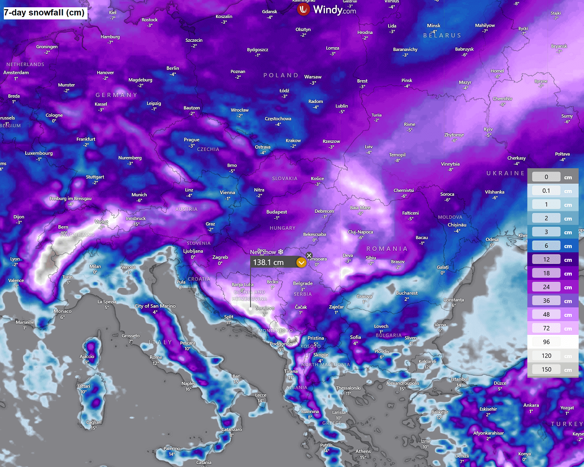
We can also see that most of central Europe, including most of Germany, France, Czechia, Poland, and Slovakia, will receive some decent snowfall over the next 7 days. The major snowstorms, however, will remain across the Balkans and Eastern Europe.
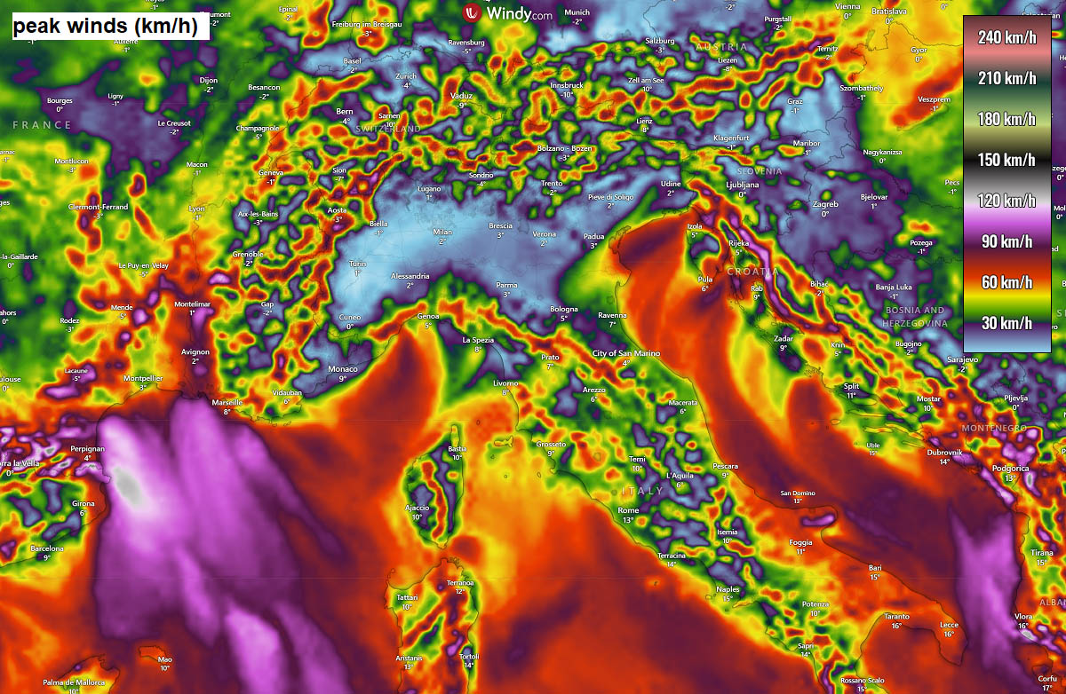
Another concern is severe downslope Bora winds developing over the Dinaric mountain range and along the Adriatic coast, with peak wind gusts exceeding 120-150 km/h through several days.
Those winds, combined with heavy snow, will result in severe blizzard conditions in parts of southwestern Slovenia, Croatia, Bosnia, and Montenegro. Travel disruptions and roadblocks are expected.
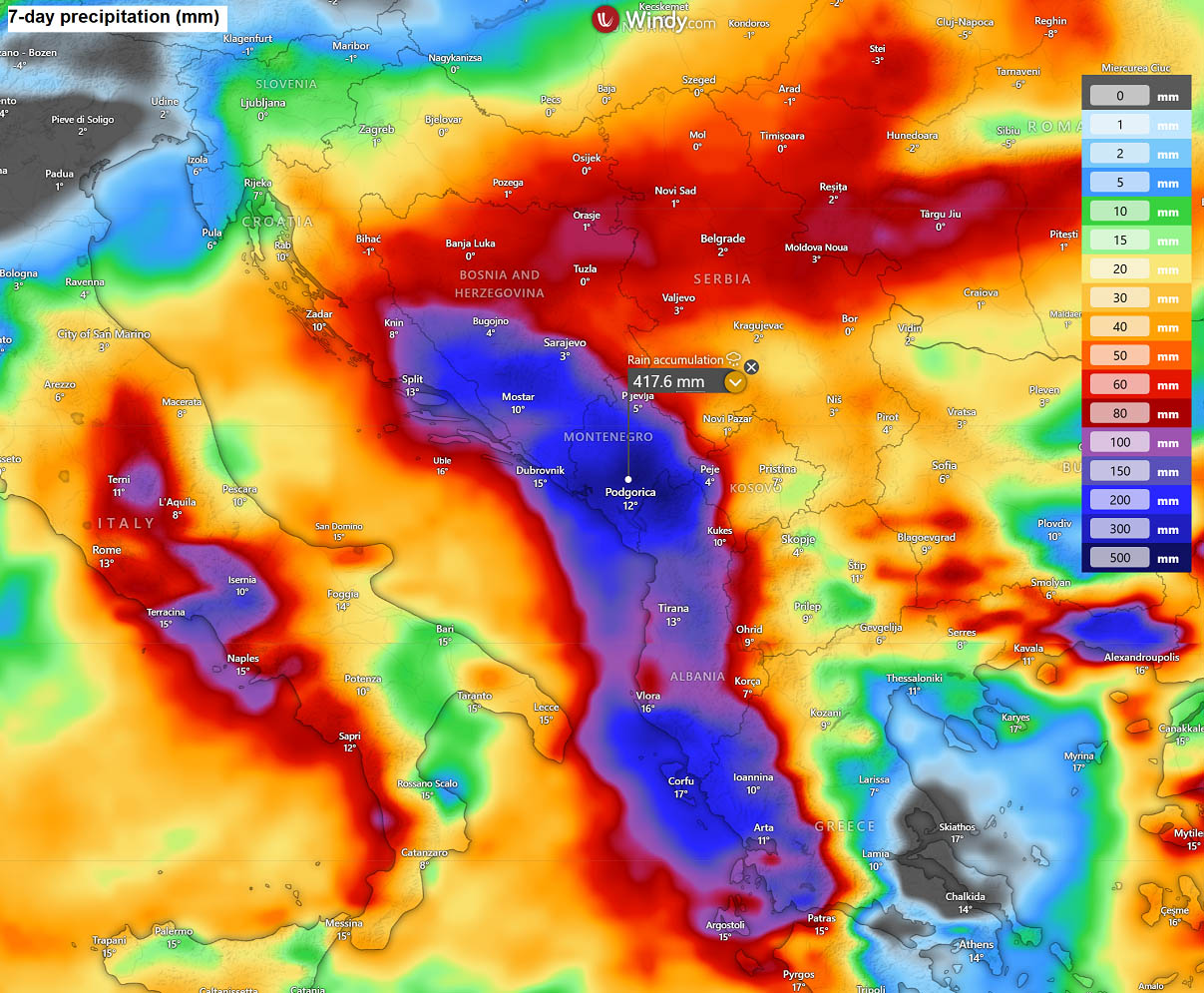
While persistent moisture and a warmer air mass from the Mediterranean into the Balkans will feed winter storms, a warmer air mass over coastal areas of Montenegro, Albania, and Western Greece will result in heavy, excessive rainfall.
Rainfall accumulations could reach up to 400 mm until the following weekend in Montenegro.
On the back side of the large deep trough parked over the Mediterranean, cold air mass and moisture advection will bring heavy snow into the higher terrain of Morocco and northern Algeria. There, 20-30 cm of fresh snow will be possible by Friday.
A lot of fresh snow, up to 50 cm, is also expected across the higher terrain of northern Spain and the Pyrenees next week.
Intense Atlantic Storm likely to impact Western Europe Friday through Sunday
Once the major trough weakens towards the late next week, some changes in the pattern could follow as the North Atlantic sends new deep lows towards Western Europe.
On Friday, global weather models hint at a deep wave emerging into Ireland and the UK, which could be a fast-moving, intense winter storm.
Attached is the surface pressure forecast for Friday, indicating how a more zonal flow may establish, returning an intense Atlantic storm into Western Europe. With a significantly deep core, it could become the next named storm for Ireland and the UK.
The central pressure is hinted at in the 960s to 970s per some models, so a deep, extensive system may evolve from Friday into Saturday. With still cold weather persisting over Western Europe, snow will be possible in some areas.
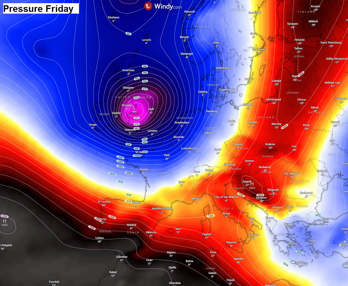
The temperature picture for Friday across Europe indicates that the major trough forecast to dominate this new week will gradually weaken, and the cold will spread east into Eastern Europe as well, while the low fills and weakens over the following weekend.
Ahead of it, warm advection will spread into Russia.
As mentioned, the new Atlantic wave and potential winter storm on Friday could bring some snow to Western Europe late next week.
While it is hard to predict the exact path of the surface lows and where the snow could blanket the region, trends do show some decent potential for Friday and Saturday.
Some more snow could then also spread across Benelux and Denmark.
We continue to monitor patterns as we head towards mid-January, as another warming is forecast for the Stratospheric Polar Vortex, and more significant weather impacts could follow. Stay tuned for further updates.
Windy, and Wxcharts provided images used in this article.
See also:
Polar Vortex 2026 Update: New Stratospheric Warming Detected, Winter Shift Likely in January