Severe weather outlook – forecast across Europe. This forecast features areas of organized severe weather with risk levels and severe weather threats across the European continent.
SEVERE WEATHER OUTLOOK
Valid: 27/07/2025 06 UTC – 29/07/2025 06 UTC
Issued by: Severe Weather Europe
Forecaster: Marko Korošec
SUMMARY
The ongoing scorching heatwave across southeastern Europe will finish with a deep upper wave emerging from the west, producing a significant severe weather event across the Mediterranean and the Balkan countries.
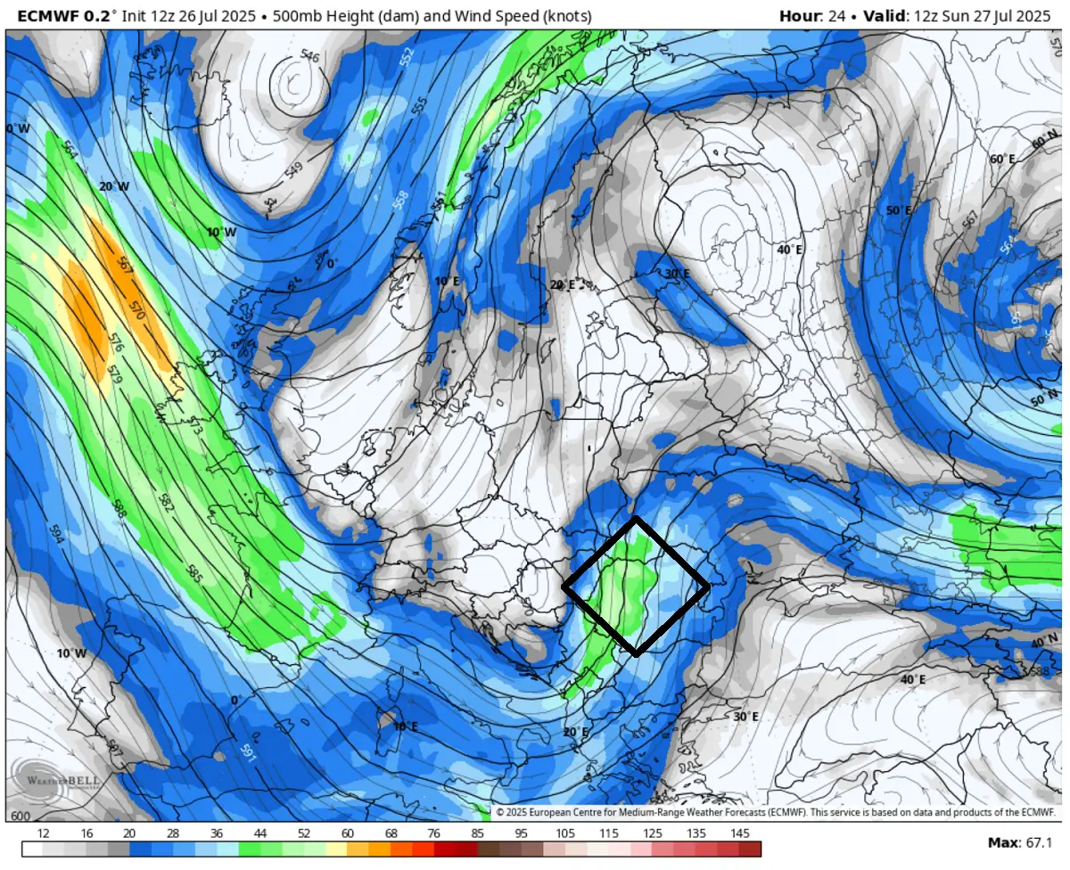
A powerful jet stream rounding the base of the upper trough will provide widespread forcing to support an explosive thunderstorm development within a strongly sheared and unstable air mass over the eastern Balkans on Sunday. A volatile environmental condition with a severe weather outbreak of supercell thunderstorms, including tornadoes and large hail, damaging winds, and torrential rainfall, is forecast.
On Monday morning, another deep wave emerging over the Alps into the northern Mediterranean is forecast to bring another round of robust thunderstorms to Italy and the Adriatic Sea region. First, the activity will develop over the Alpine region and northern Italy early Monday, followed by widespread severe weather across the Adriatic and the western Balkan peninsula until Tuesday morning.
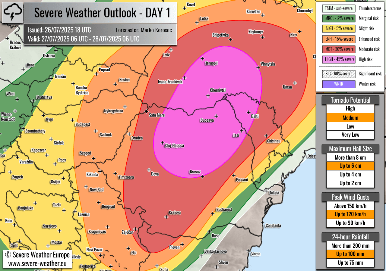
For this reason, a 2-day HIGH + MDT risk has been placed across the Mediterranean and the Balkan peninsula, with highlighted areas where the most robust severe weather threat will develop on Sunday and Monday. The threat also includes enhanced potential for tornadoes and very large hail (5 cm or larger).
Above: Video animation of the convective storm’s development across Europe from Sunday early morning through Tuesday, July 27th to 29th, 2025.
SYNOPTIC OVERVIEW
On Sunday and Monday, the weather pattern evolving over the North Atlantic and Europe indicates a deep and large upper-level trough emerging into central Europe and the Mediterranean, paired with a blocking High over the Atlantic. Widespread upper-level forcing is forecast to support volatile weather development. Ahead of it, over southeastern Europe, an extensive heat dome with scorching heatwave continues.
At the surface, a frontal system with a surface low is moving across the east-central Balkans on Sunday. Another frontal system and a surface front are emerging over the Alps into the northern Mediterranean as the main upper wave arrives early Monday morning.
WEATHER FORECAST DISCUSSION – Sunday, July 27th
+++ Weather forecast for Romania, Moldova, and Ukraine +++
Explanations for abbreviations (TSTM, SLGT, ENH, etc.)
Highlighted severe weather threats:
- Tornado potential: Medium
- Maximum hail size: Up to 6 cm
- Peak wind gusts: Up to 120 km/h
- 24-hour rainfall: Up to 100 mm
HIGH risk has been issued for northeast Romania, northern Moldova, and southwestern Ukraine, with a threat of severe damaging winds, large to very large hail, torrential rainfall with flash floods, and tornadoes.
MDT/ENH risks have been issued for areas surrounding the HIGH risk area, including central Moldova, central and western Ukraine, most of Romania, southeast Poland, northwestern Bulgaria, and Serbia, with a threat for severe winds, large hail, and torrential rainfall. The expected storm coverage is forecast to be lower than inside the highlighted purple risk area.
Ahead of an emerging frontal system from the west, powerful south-westerlies aloft are advecting very high moisture from the southern Mediterranean region towards the eastern Balkan peninsula. High dewpoints will result in a moderately unstable air mass with MLCAPE reaching 2000+ J/kg over eastern Romania to Ukraine.
At the same time, ample wind shear is also overspreading the region, thanks to the increasing jet stream aloft. Therefore, a strong forcing develops near the left-exit region of the jet.
A combination of intense wind shear and high instability will lead to a volatile environment with the explosive development of severe thunderstorms on Sunday midday. Supercell thunderstorms are expected as a primary mode, as well as training multicell storms with a potential flash flood threat. Storms will rapidly become severe, with threats from large, wind-driven hail to intense, damaging winds and torrential rainfall.
The tornado threat is maximized from extreme northeast Romania to northern Moldova and southwestern Ukraine, where strong easterly near-surface winds are present, supporting enhanced storm-relative helicity.
Storms will likely merge into a larger cluster and move further east-northeast into Ukraine in the afternoon and evening hours. These storms will primarily enhance the threat of large hail, severe damaging winds, torrential rainfall with flash floods, and, to a lesser extent, tornadoes.
WEATHER FORECAST DISCUSSION – Monday, July 28th
+++ Weather forecast for Italy, Adriatic Sea, Croatia, Hungary, Bosnia and Herzegovina, and Montenegro +++
MDT/ENH risks have been issued for northern Italy, Adriatic Sea, southern Croatia, western Bosnia, south-central Serbia, and northern Albania with a threat for severe winds, large hail, torrential rainfall, and tornadoes.
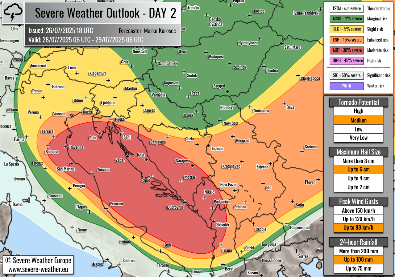
Highlighted severe weather threats:
- Tornado potential: Medium
- Maximum hail size: Up to 6 cm
- Peak wind gusts: Up to 90 km/h
- 24-hour rainfall: Up to 100 mm
On Monday, another severe weather setup is forecast across the Mediterranean region, associated with a frontal system arriving with the main upper trough aloft.
With the progress of the cold wave aloft, a surface low forms over the Po Valley and moves towards the central Adriatic Sea; low-level winds will significantly intensify towards the low. Cold upper levels will keep the instability high, with 1500-2000 J/kg of MLCAPE.
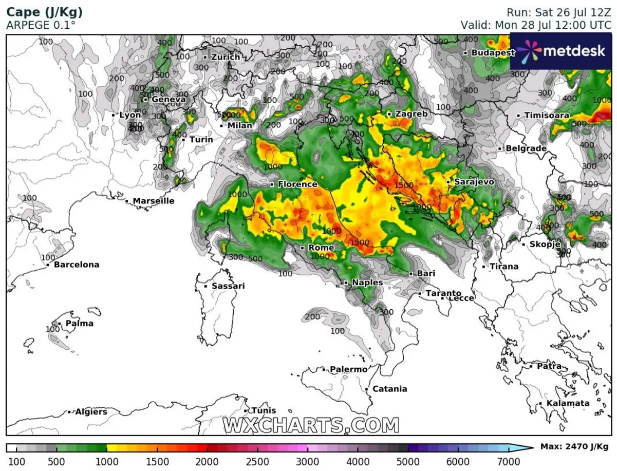
Therefore, the environment will be conducive for the explosive and rapid development of isolated to scattered multi- and supercell storms from early morning into the afternoon on Monday.
Severe thunderstorms will track east-southeast across the Adriatic Sea, reaching coastal areas in the Kvarner and Dalmatia regions in Croatia. Strong winds aloft will support widespread storm activity, including supercells. With time, storms will likely merge into large clusters and could develop bow echoes with damaging winds and torrential rainfall with flash floods.
MDT risk has been placed where the most robust storm activity is expected. The activity will gradually spread east-southeast and vanish by Tuesday morning.
SEE ALSO: A deep cold wave brings cooler conditions in part of Europe as July ends