SYNOPSIS
An upper ridge over W and CNTRL Europe collapses with a deep trough over N Europe digging more south. Two intense cold core lows are moving over S Scandinavia and E of Baltic region. Another large upper low remains over W Iberia while a pronounced short-wave with frontal boundary is located over the Alps.
DISCUSSION
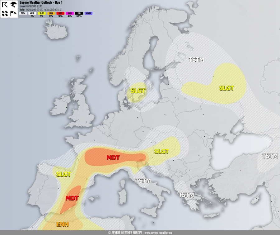
MDT risk has been issued for S-CNTRL France, S Switzerland into N Italy and W Slovenia with threat for severe storms, capable of producing severe winds, torrential / excessive rainfall, large to very large hail and some tornado threat. Scattered intense storms are expected to develop, including well-organized supercells within the moderately strong shear (40-50 knots of bulk shear) and locally an extremely unstable environment (2500-3500 J/kg of MLCAPE). Increasing SE-erly near-surface winds will also contribute to enhanced SR helicity, favorable for low-level mesocyclones and some tornado threat across France and NE Italy region. Storms could merge into a large cluster / MCS in the evening across SE France towards Switzerland and also from NE Italy towards the N Adriatic and W Slovenia with mainly damaging wind / large hail threat. High PWAT will support flash floods threat as well.
MDT risk has been issued for E Spain with threat for severe storms, capable of producing severe winds, torrential rainfall and large to very large hail. Strong shear (50-60 knots) overlapped with high instability (MLCAPE 1500-2000 J/kg) will support organized severe storms, including supercells. Isolated very large hail will be possible with the most robust updrafts as steep mid-level lapse rates are present as well.
ENH / SLGT risks have been issued for areas surrounding the MDT risk across central Europe, E Iberia into NE Morocco and N Algeria with more isolated threat for severe storms, capable of producing severe winds, large to very large hail and torrential rainfall.
SLGT risk has been issued for S Sweden into E Denmark with threat for isolated severe storms, capable of producing severe winds and large hail.
SLGT risk has been issued for E Belarus into NW Russia with threat for severe storms, capable of producing severe winds, marginally large hail and torrential rainfall.
TSTM risk areas have been placed where convective storms are likely to occur but should remain sub-severe.


