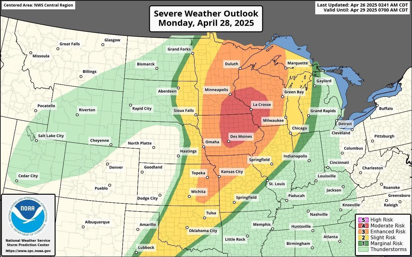
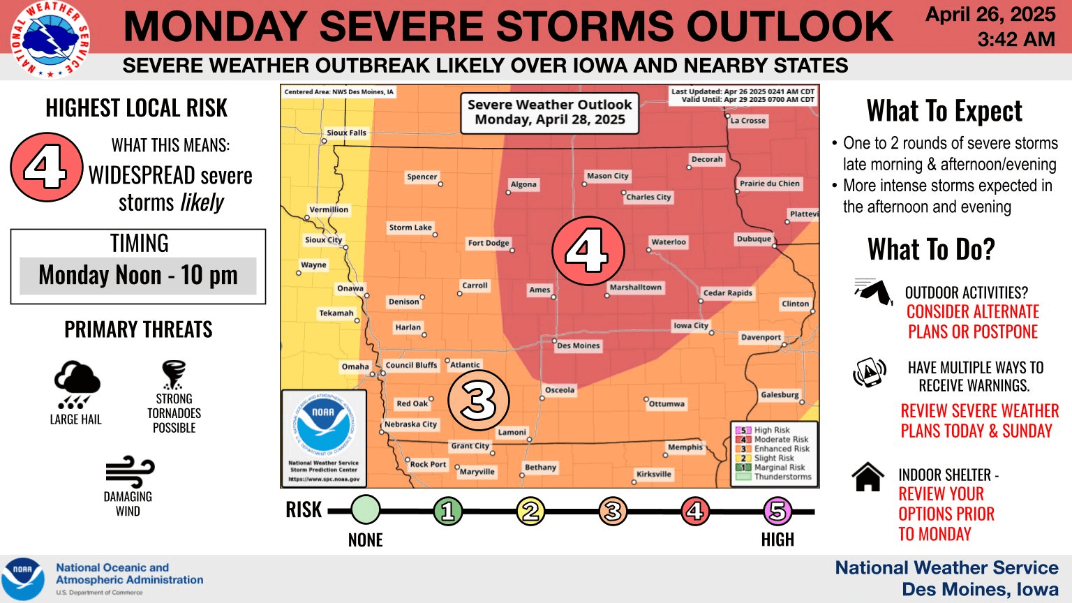
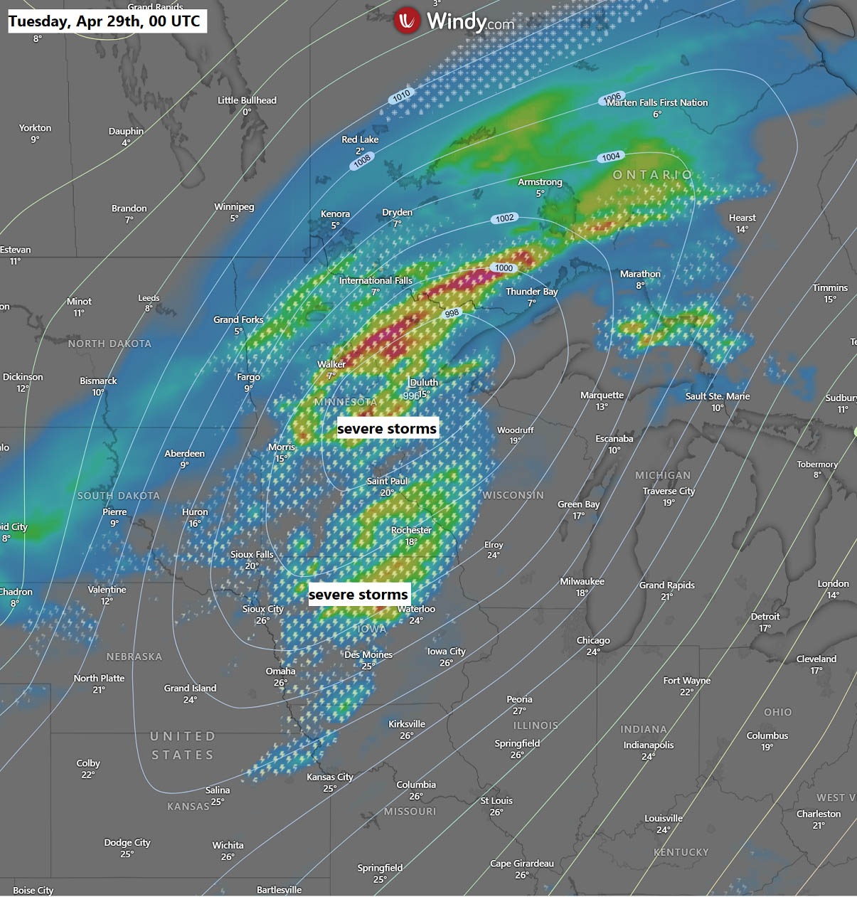
Severe weather activity continues across the heart of the central United States this weekend, while the focus now shifts to Monday. A fast-moving upper-level wave will amplify the jet stream with significant moisture surging across the Upper Midwest. Powerful wind shear and instability are expected to combine, supporting a widespread severe weather and tornado outbreak from Minnesota and western Wisconsin across Iowa to eastern Kansas and western Missouri.
By Monday afternoon, a significant severe weather threat will develop from the Upper Midwest to the Central Plains as the frontal system pushes eastward from the Dakotas.
The greatest threat is maximized in the corridor from southern Minnesota, western Wisconsin, to Iowa, northern Missouri, and eastern Kansas, where the likelihood of dangerous severe weather, including strong tornadoes, is the highest.
That includes cities such as Minneapolis, Minnesota; Des Moines, Iowa; and Kansas City, Missouri.
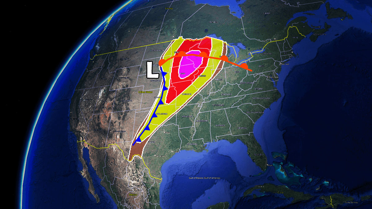
Tornadoes, some of which may be strong (EF2 or greater damage), as well as large to very large hail and damaging winds, are the primary threats. Storms are forecast to start as supercells by Monday afternoon, before a further cold front push leads to a transition to an intense squall line with embedded tornadoes on Monday night.
Here is a quick animation overview of the upper wave and frontal system passing across the north-central U.S. from Sunday through Tuesday. Widespread severe weather activity is expected across the Upper Midwest.
Typically, large hailstones with a diameter of 3 to 5 inches are accompanied by these violent storms. Just this week, giant hailstones of more than 5 inches fell on Motley and Floyd counties in Texas.
Extreme instability, supporting intense storm updrafts within thunderstorms, is capable of producing hailstones the size of baseballs and grapefruits. They often exceed 100 mph speeds.
Do you know how these large hailstorms form?
Hail formation – how hailstones grow this large?
Hail or hailstone forms as supercooled water droplets within a thunderstorm updraft begin freezing onto a condensation nucleus. The supercooled droplets have a temperature below freezing (0 °C or 32 °F), but are still in a liquid state.
As they come into contact with the growing hailstone, they freeze onto it, making it grow larger. The ever-increasing hailstone is kept in the air by the storm’s updraft until it grows too big and heavy for the upward wind to keep it aloft.
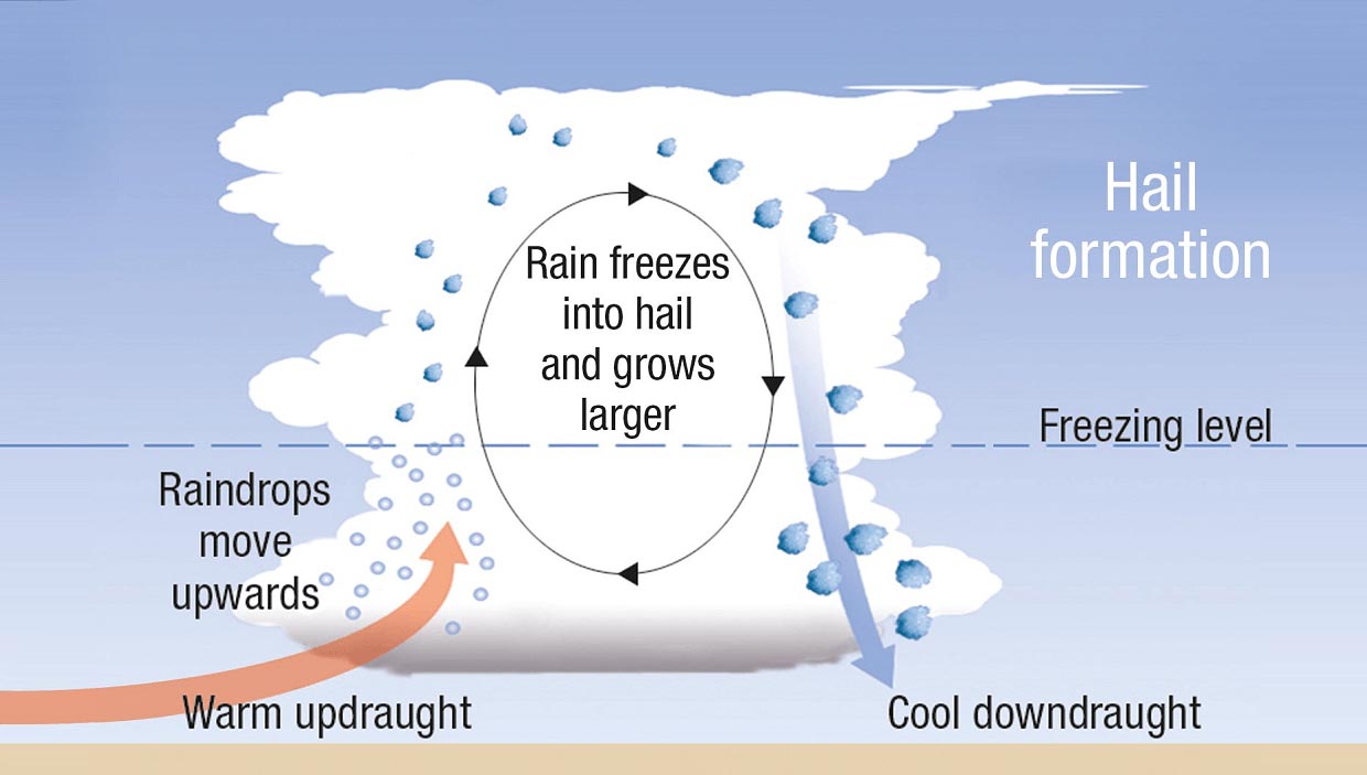
How hail forms. Graphics by Bureau of Meteorology
The hailstone may make a single round within the storm’s updraft, but often, it makes several rounds within the updraft. Each round forms a new layer of ice around the chunk of ice, producing a concentric onion-like structure.
Some hailstones form and grow by many smaller hailstones sticking and freezing together into a large hailstone – such a form is called an agglomerate. The largest hailstones sometimes even form long icy horns or spikes!
The most severe hailstorms and the most significant hail are usually associated with supercell thunderstorms. It takes very high to extreme instability, strong wind shear, and dry mid-levels for massive hail to form.
A potent upper trough with an intense surface low across the Upper Midwest
Another significant upper wave has emerged on the West Coast and is forecast to travel east across the nation through early next week. An amplified jet stream is expected to develop across the central United States, with maximum intensity in the Great Plains and Upper Midwest on Monday.
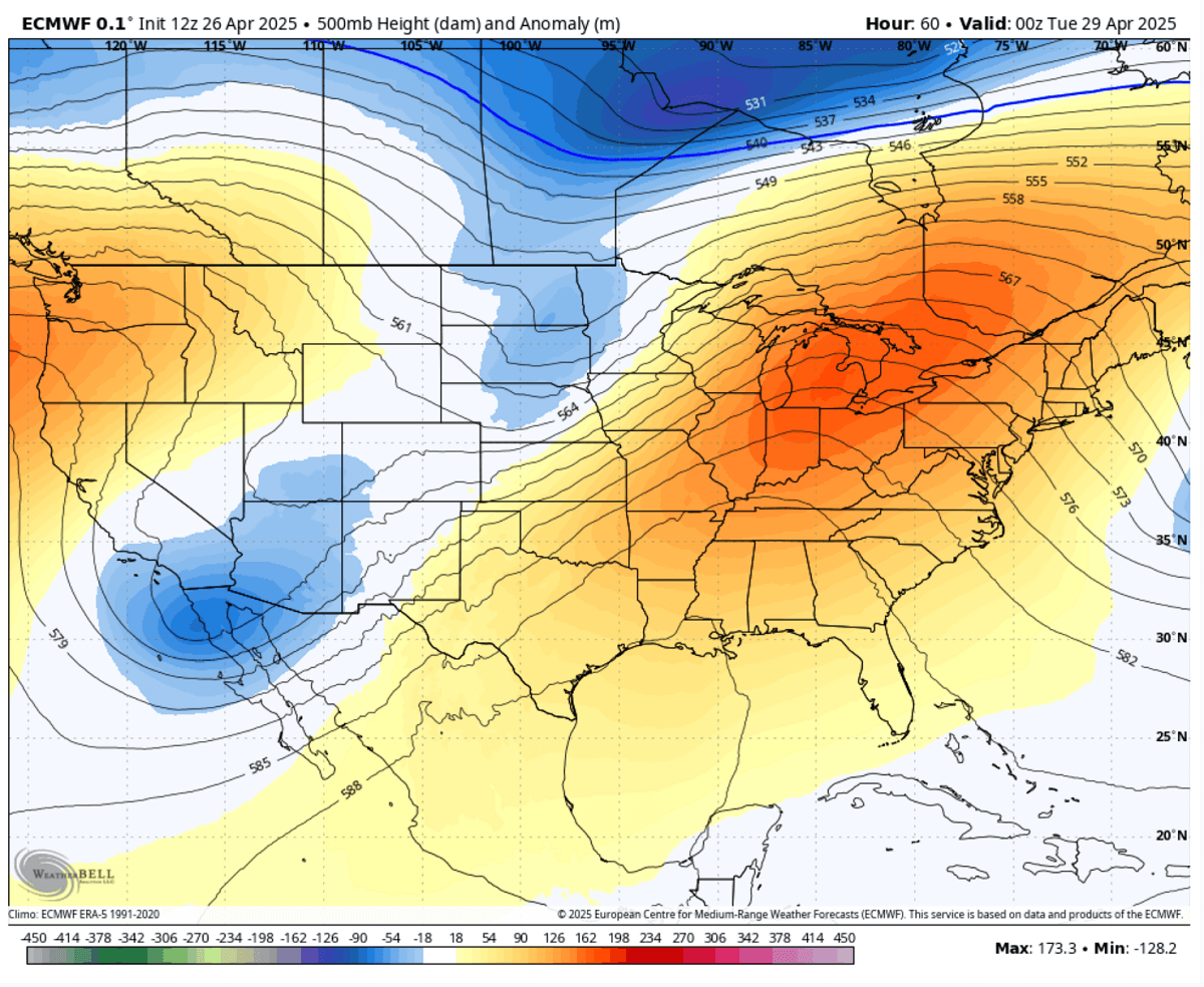
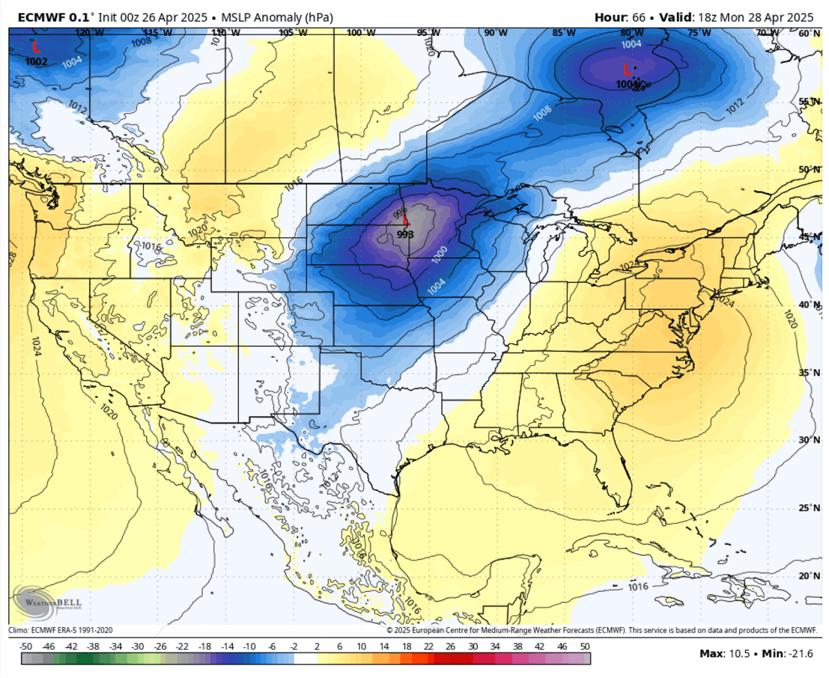
By Sunday afternoon, a frontal system will move across the Northern Rockies with a surface pressure that will gradually deepen. Once the upper wave emerges into the Northern Plains, the surface low significantly deepens and moves east across the Dakotas on Monday.
The central pressure is forecast to reach the low 990s by Monday afternoon hours when the cyclone matures.
A fast-moving upper-level wave will amplify the jet stream across the Upper Midwest, with a significant moisture surge across the Missisippi Valley northwards underneath the wave aloft.
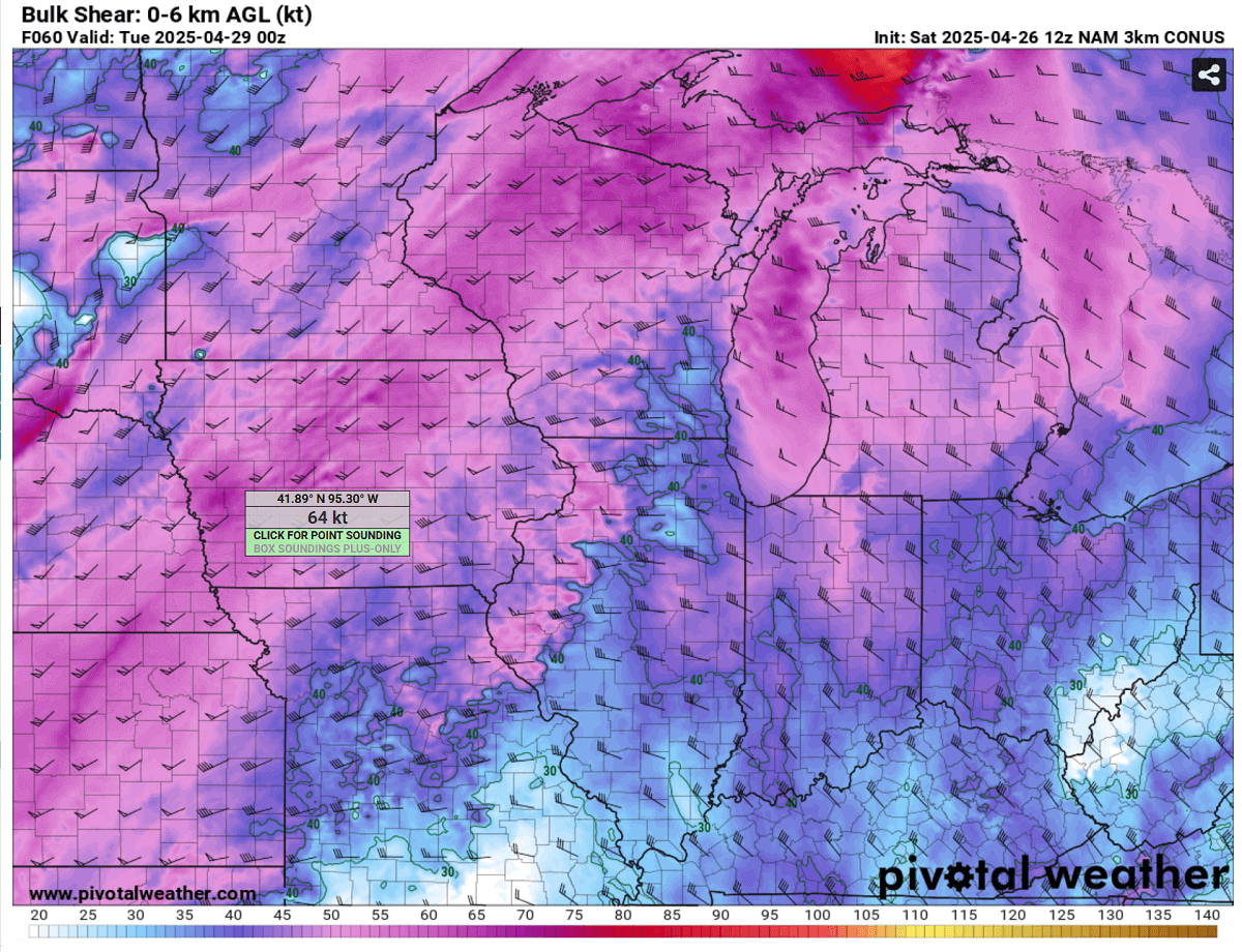
The most intense upper-level winds will be located from Kansas across Iowa to southern Minnesota and Wisconsin at the time the widespread severe weather is expected to occur.
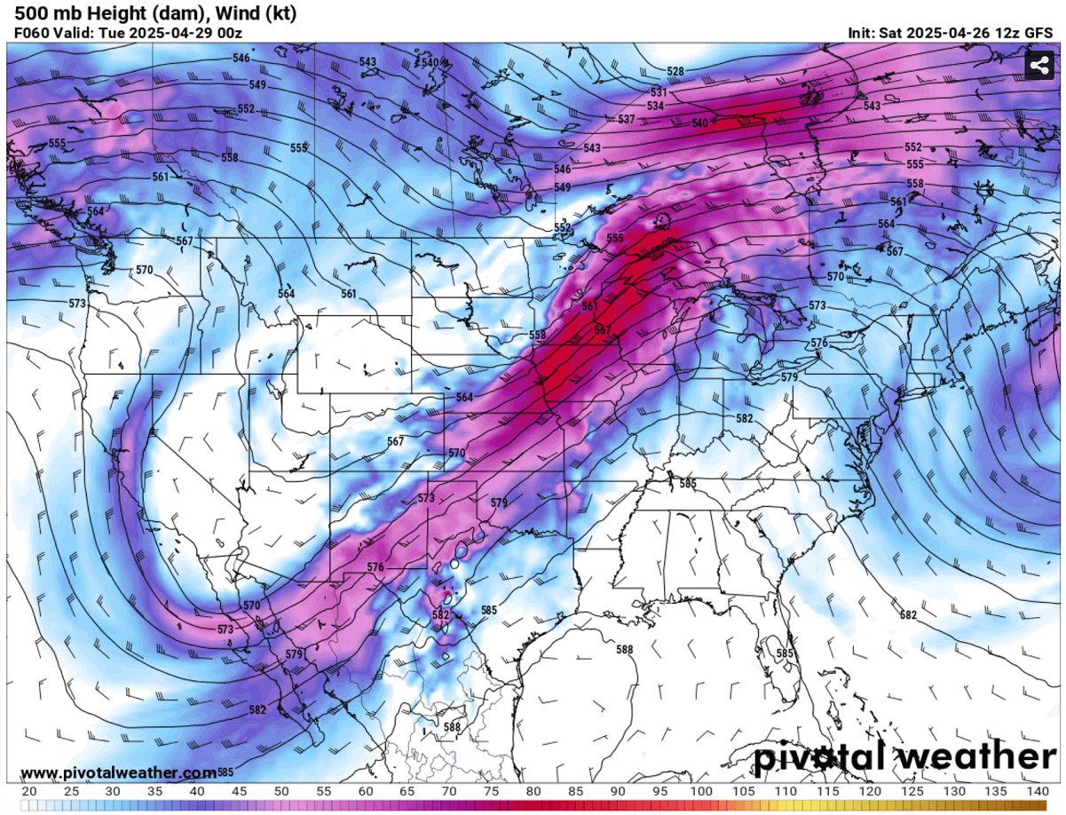
The wave and associated significant storm activity will be spreading east through late Monday into Monday night.
Conditions are in place for a significant severe weather and tornado outbreak on Monday
According to the latest weather model guidance, a tornado outbreak is likely over parts of the Corn Belt and Upper Midwest on Monday.
Intense supercell thunderstorms will be possible as far south as Oklahoma City and Dallas-Fort Worth and northeast across Kansas City, to Des Moines and Minneapolis, where a tornado outbreak is forecast.
Monday features a typical synoptic-scale and widespread severe weather outbreak where the strongest isolated supercell storms could produce significant EF2+ tornadoes, in addition to damaging winds and large hail.
Across the Upper Midwest, two rounds of storms are expected, with isolated, intense supercells forming in the afternoon, followed by a significant squall line racing across Minnesota and Iowa to the east on Monday night.
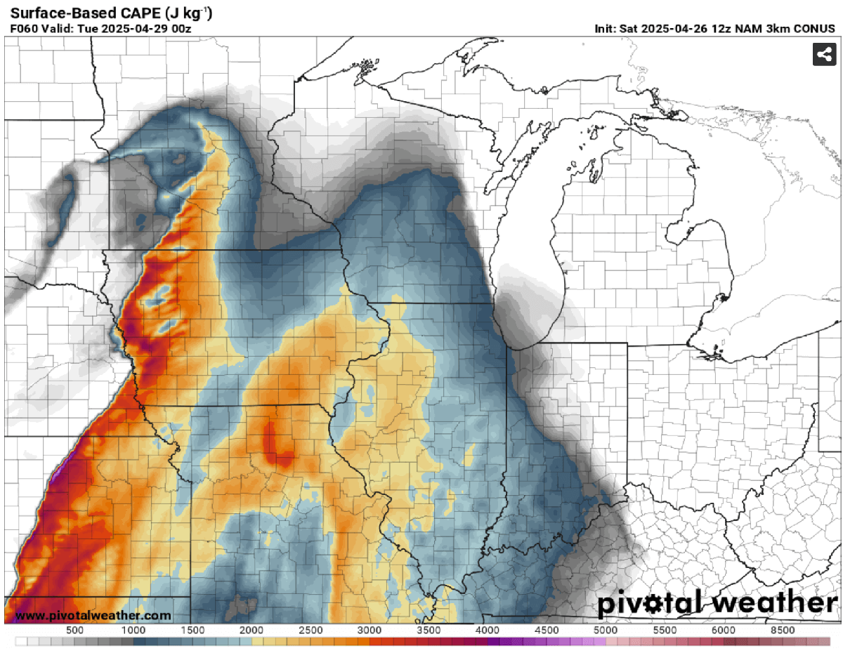
The deepening surface low on Monday will result in a significant northward surge of high moisture, amplifying atmospheric instability across the region.
The highest instability is forecast across the warm sector, destabilizing south of the warm front as it moves north across the Upper Midwest during the afternoon hours. The highest instability (CAPE – Convectively Available Potential Energy) will exceed 3000 J/kg in eastern Kansas and Iowa.
The eastward-moving frontal system beneath the powerful jet stream aloft will lead to the rapid initiation of thunderstorms within this volatile air mass. This will allow strong wind shear to develop across the central Plains to the Upper Midwest, with the highest values of 0-6 km bulk shear exceeding 60 knots.
This, combined with high instability, creates a conducive environment for severe storms with large hail and tornadoes.
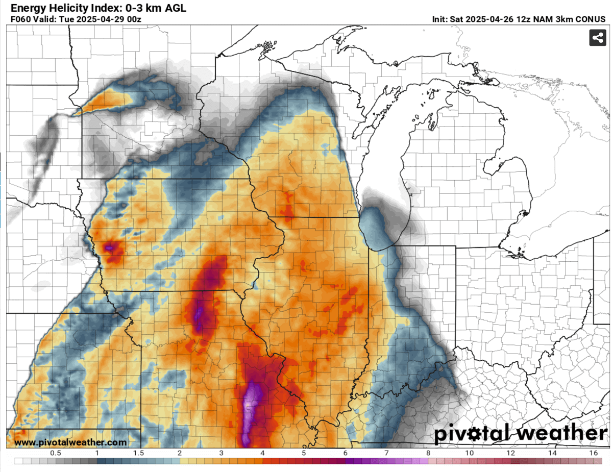
The following chart represents the so-called EHI index – Energy Helicity Index, a metric that combines instability and wind shear in the lowest 3 km of the atmosphere. Values forecast will exceed 5 across parts of the warm sector.
The higher the EHI, the higher the potential is for intense tornadic storms. Strong tornadoes occur when EHI is above 5, while values above 10 typically support a volatile storm environment where violent and long-tracked tornadoes can develop.
Thunderstorms are first forecast to form over the Corn Belt by early afternoon on Monday, as the jet stream aloft emerges into the region from the west. Initial storms will likely be isolated and discrete, a typical environment conducive for intense supercells capable of all severe weather hazards; large hail, damaging winds, and tornadoes.
Given the fast-moving upper wave, it is unclear how many potentially intense tornadic supercells will form ahead of the main evening intense squall line storm cluster. This potential is likely to occur across Iowa, south-central Minnesota, and western Wisconsin during the late afternoon and early evening hours on Monday.
In the evening hours, the stronger push of the cold air mass in the wake of the frontal system will initiate a gradual but rapid clustering of the storms into a more linear mode, forming an intense squall line that will race east overnight, supporting widespread damaging gusts and embedded tornadoes.
Below is the vertical sounding diagram forecast for western Iowa for late Monday afternoon. It represents a significant weather condition conducive to intense tornadoic supercell storms. Until storms remain isolated and discrete, conditions will support strong EF2+ tornadoes and very large hail.

The upper-left part of the image represents the temperature and dew point forecast throughout the atmosphere, from the ground to the upper levels, with wind speeds and direction to its immediate right side. We can see that a strongly sheared environment will be in place.
The upper right corner is the hodograph chart, representing the veering winds with height. Southeast winds will be present in the lowest levels, transitioning into southwesterlies and intensifying as we rise higher in the atmosphere. A typical tornado environment is forecast.
The bottom part of the image represents various calculated indices; the CAPE is expected to exceed 4000 J/kg, with a 0-6 km bulk shear exceeding 75 knots. Combined, this environment results in an EHI index of 6 or higher within the lowest 1 km—a strong indicator of a tornado.
Isolated but intense storms are possible across the south-central Plains
Although there will be less upper-level winds and support further south ahead of the eastward-moving cold front, a few isolated and discrete supercell storms are expected to form by late Monday afternoon.
Cities such as Dallas-Fort Worth, Oklahoma City, Wichita, and Kansas City are expected to experience severe weather on Monday.
These storms are likely to produce isolated large hail and tornadoes as well.
Wxcharts, WeatherBell, and Pivotalweather provided images used in this article.
See also: