The Western Pacific season activity is significantly increasing lately. Soon after a damaging Typhoon Molave over the Philippines and Vietnam, a new extremely rapid development of a typhoon is underway. Typhoon Goni has become the strongest Earth’s storm of the year! A violent storm is moving towards its potentially destructive landfall in Luzon this Sunday.
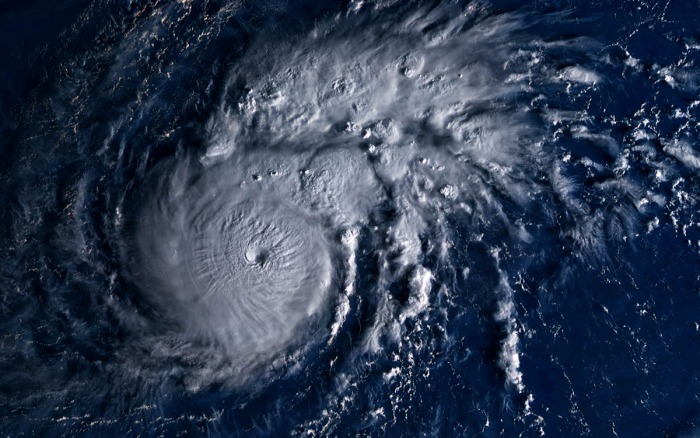
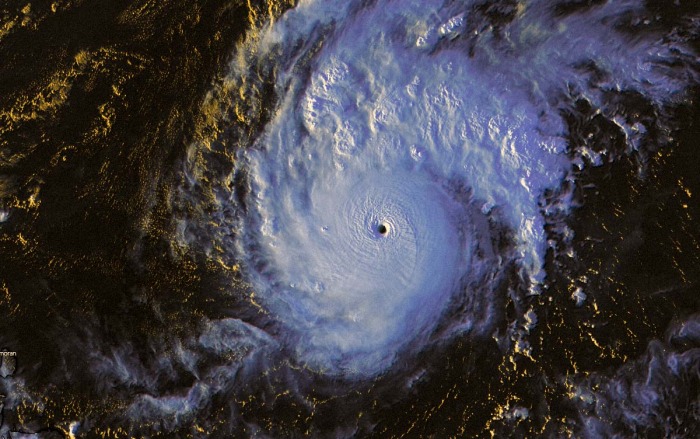
As of 06 UTC on October 30th, Typhoon Goni (Rolly) was located near 16.4 °N and 131.6 °E. About 725 nautical miles (1340 km) east of Manila, Philippines. The multispectral enhanced infrared satellite imagery shows a very compact system with a 11 nautical miles pinhole eye visible.
Typhoon Goni has undergone an extremely rapid intensification over the past 12-18 hours. The initial intensity is officialy set at 150 knots, aligned with the Dvorak (ADT) current intensity estimate of T7.2 (145 knots).
Attached below is a spectacular view by the Himawari-8 satellite!
Morning scan:
Evening scan:
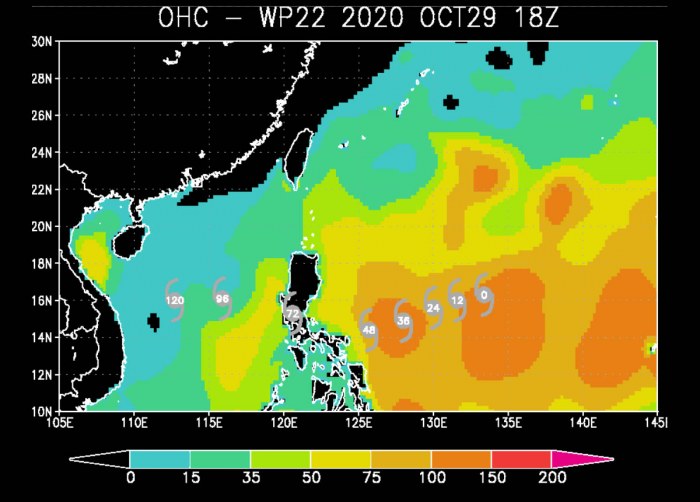
The system continues moving through an environment that is extremely favorable for additional rapid intensification, with very warm waters and high Ocean Heat Content (OHC) values. Low shear is present across the whole area ahead of the typhoon.
Explosive development into a powerful typhoon is increasingly likely, as weather models hint that Typhoon Goni could maintain a Category 5 strength over the next 36 hours!
A potentially destructive landfall is likely somewhere in central Luzon on early Sunday.
After the landfall, Goni weakens while crossing the mountainous terrain of central Luzon and then the system re-emerges into the South China Sea and head towards its secondary landfall in Vietnam.
The environmental conditions over the region suggest that more storms is increasingly likely over the Western Pacific next week.
EXTREMELY WARM WESTERN PACIFIC OCEAN
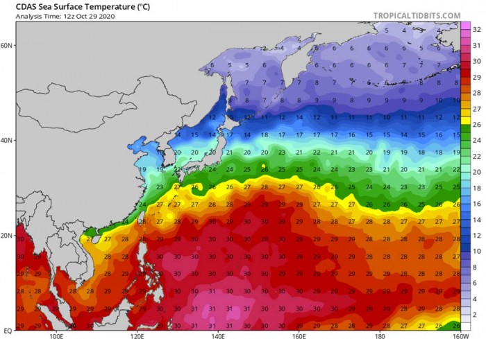
A large part of the Western Pacific remains extremely warm. That is exactly where the new typhoon (and further storms next week) will track. The sea waters are very hot! Sea surface temperatures of 30-31 °C are spread across the Philippine Sea, all the way west of Marianas and the Philippines.
Even warmer, close to 32 °C sea waters are present over the southern portions of the Philippine Sea.
The sea waters are very much above the normal long-term average through elate October. Nearly 2 degrees Celsius warmer, even 3 °C above the average in some areas of the Western Pacific tropical region. This means that the oceanic conditions are beyond exceptional and these conditions will help Typhoon Goni to become a very violent typhoon this coming weekend.
Goni will be tracking over these extremely favorable, hot oceanic conditions through its whole lifecycle. On Sunday this week, the typhoon reaches the Philippines. It could be very intense at that time.
The Ocean Heat Content (OHC) values are very high right now, above 150, and should stay similar over the next 48 hours. This often contributes to a very rapid (explosive) intensification of tropical systems.
Which is actually what is Typhoon Goni undergoing now. We could be seeing its extreme deepening and strengthening on Thursday into Friday (local time).
It is very likely that Goni will continue rapidly intensifying for at least another 2 days and become a monster typhoon with 130+ knots winds. The potential is definitely there the system maintains a powerful Category 5 system until prior to landfall in the Philippines.
EXPLOSIVE DEVELOPMENT UNDERWAY
Goni has begun its rapid intensification on Wednesday afternoon after a tropical depression emerged west of Marianas. Very explosive convection has appeared on the satellite scans, and Goni has been upgraded into a typhoon on Thursday morning. The central pressure has also begun rapidly deepening over the past 24 hours.
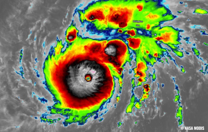
The attached NASA MODIS infrared satellite scan below reveals that the cloud tops temperatures are already extremely low, shooting below -85 °C at times! This is a sign that convection is very intense.
There was also a pinhole eye appearing on different satellite channels, which is a typical sign that an explosive burst of storms is developing a very intense tropical system.
The upper-level outflow ventilation is exceptional, wide open in all directions. Meaning the wind shear is very low.
Goni is already a Category 4 Typhoon right now and on its way to potentially become a Category 5 storm (as of Saffir-Simpson scale).
The latest Advanced Dvorak Technique (ADT) estimates are a bit lagged behind the official analysis for now, but indicating that Typhoon Goni is becoming a very powerful storm. The maximum sustained winds have increased to near 100 knots (115 mph, 185 km/h) with central pressure around 950 mbar. Its tropical-storm-force 50-knot winds are spread across the 40-50 mile radii around the small eye.
While Goni also has around 20-30 radii of hurricane-force 64-knot winds. The wind field is expanding and strengthening.
There is barely anything that could stop Goni’s intensification. One of the reasons to disturb its strengthening would be an Eyewall Replacement Cycle (EWRC). But since Goni has just built a pinhole eye, there is still a lot of time it builds a large eyewall with wider and undergoes a replacement cycle.
We will likely be seeing a continuing explosive development over the next 12-24 hours.
FORECAST BRINGS GONI TO PHILIPPINES
Typhoon Goni is forecast to track west-southwest over the next 3 days, while it continues rapidly deepening its central pressure and strengthening the winds. The hot ocean waters are well reflected in the intensity model guidance which continues to favor an extremely rapid intensification to continue until Goni arrives closer to the Philippines.
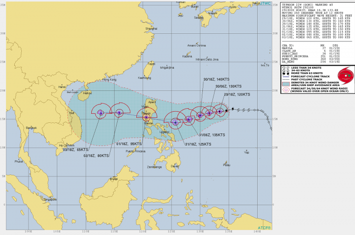
Explosive development into a powerful typhoon is increasingly likely, based on the latest weather model runs. Attached below is the JTWC forecast track for Goni. The JTWC hints Goni would become a Category 5 on late Friday night!
Goni is tracking westward under the steering influence of a large, deep-layer subtropical ridge with a new center developing just northeast of Goni, pushing it back onto a westerly course a bit faster than anticipated.
The overall very low deep-layer shear will have no effect on the system’s further strengthening. So a very rapid intensification is expected to continue at least until Saturday. The JTWC forecast suggests, that Goni will become a violent typhoon of around 130 knots (150 mph, 240 km/h) and head towards the Philippines on Sunday this coming weekend.
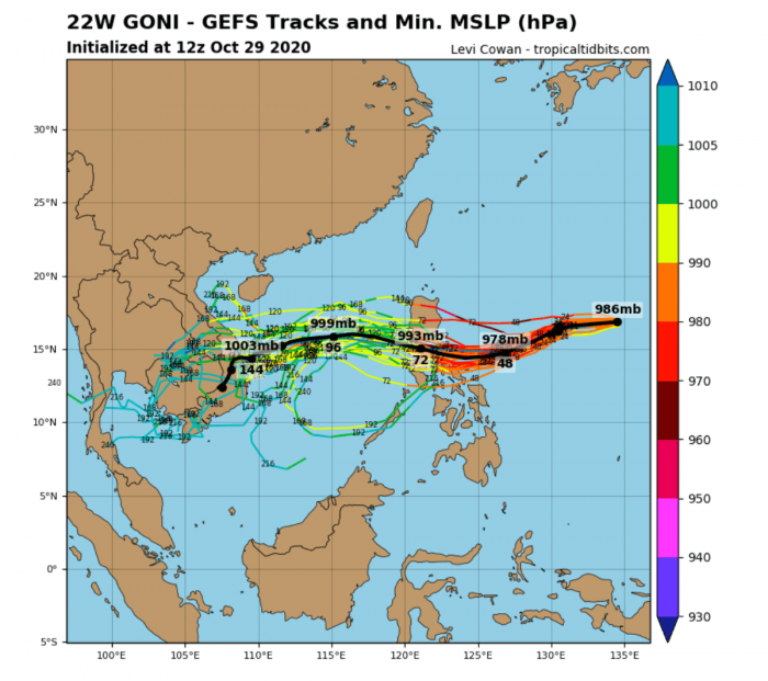
Most of the weather models in the ensemble forecast agree on the roughly westerly track through the next 3-5 days is likely, with some potential that the track shifts more to the southwest prior to its arrival to the Philippines.
Nevertheless, the general direction of tracks brings Goni into northern portions of the central Philippines (Luzon) on Sunday morning local time.
EXTREME RAINFALL AND STORM SURGE IMPACT LIKELY
Typhoon Goni comes soon after the typhoon Molave which has crossed the central Philippines earlier this week. Molave re-emerged and rapidly intensified over the South China Sea and blasted into Vietnam. It was the 4th storm to hit the nation this month.
What the weather models are simulating is a real concern for the Luzon, Philippines. The path and the potential landfall of Typhoon Goni bring the system as a very powerful impact on the country. It may be of at least a Category 3 strength when it strikes on Sunday.
An extremely dangerous situation is therefore developing as the region could be severely hit by violent winds and flooding. The impact of life-threatening storm surge is also very likely.
Attached are the wind swaths of the potential tracks and intensities over the next 10 days, per the ECMWF model. It shows a very severe impact of Typhoon Goni in the central Philippines. We can also see a hint of another, potentially even stronger typhoon forming further north – that is a Tropical Depression 23W, with a designated name Atsani.
On the attached maps, provided by Windy.com, we can see that the eastern portions of the Philippines could be affected by intense winds associated with Goni. This is the European ECMWF model forecast, hinting at peak gusts exceeding 220 km/h.
A significant amount of rainfall is likely to be expected across the eastern and central Philippines. The exact amount and area of the strongest rainfall are indeed very hard to forecast, as the exact track of Typhoon Goni past Saturday could shift a bit and affect different areas than seen on the map.
Nevertheless, a huge amount of rainfall is likely, given the very hot seas and therefore high moisture available.
Typhoon Goni is expected to significantly weaken after its landfall in the Philippines. Then, the weather models are hinting its re-strengthening after it emerges into the South China Sea. Although it will be moving just a few days after the typhoon Molave, it may become a typhoon again and head for another dangerous impact on Vietnam and Cambodia.
As seen in the video animation above, the activity over the Western Pacific is significantly increasing over the next two weeks. At least another strong typhoon – Atsani – is expected. It may be even strongest than typhoon Goni while having its track somewhere between the northern Philippines and Taiwan.
While there are hints of another system possibly following Goni and Atsani later in early November. Yet to be defined in the coming days, however.
We are closely monitoring the activity in this tropical region as well and will be covering all these events.
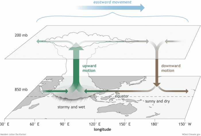
The reason for this re-developing higher activity is a somehow improved upper-level pattern. The western edge of the Madden-Julian Oscillation (MJO wave) traveling east is supporting convective activity within a divergent flow in the higher levels of the atmosphere.
MADDEN-JULIAN OSCILLATION (MJO)
The Madden-Julian Oscillation (MJO) is the largest and most dominant source of short-term tropical variability, it is an eastward-moving wave of thunderstorms, clouds, rain, winds, and pressure. It circles the entire planet on the equator in about 30 to 60 days.
Through the end of October, a new well-defined wave has moved from the Pacific into the Atlantic tropical region. It will also extend into early November.
The MJO consists of two parts: one is the enhanced rainfall (wet) phase and the other is the suppressed rainfall (dry) phase. This means there are increased storms and rainfall on one side and reduced storms and drier weather on the other side.
The air parcels are diverging (moving away) over the wet phase, and converging (moving together) over the dry phase. This horizontal movement of air is referred to as the Velocity Potential (VP) in the tropics.
We are able to track the entire MJO wave movement by looking at the larger scale air parcels movement. With the weather model data, we can easily see the areas where the air is rising and where it is subsiding.
Another important factor is the Ocean Heat Content (OHC). OHC takes into account the depth of the sea, and how warm the water layers are deep below the sea surface. In this month, we can still see a large pool of high available heat energy with a very warm water layer running down quite deep.
Deepwater being so warm as this season, provides a very favorable environment of a thick layer of warm water. Tropical systems are fueled by these warm layers, as deep convective storms draw energy from hot water.
Long story short: the thicker the warm layers are, the more fuel/energy is available to feed the storms.
The above graphics, provided by Michael J. Ventrice, Ph.D. represent an MJO wave with filtered VP200* anomalies for the current state and for the week 1 forecast.
Cold colors are representative of a more favorable state (over the Atlantic) for tropical cyclogenesis while warm colors represent a less favorable state for tropical cyclogenesis. We can see that the Western Pacific region also hints at some blueish colors, so conditions remain favorable.
*VP200 – means a Velocity Potential (VP). It is an indicator of the large scale divergent flow, so at upper levels in the tropics. The negative VP anomalies (shaded blue in the diagram) are closely tied to the divergent outflow from enhanced convective regions.
Activity seems to continue into early November, given the very favorable MJO wave pattern seen per week 1.
Typhoon – the strongest storms on Earth
A typhoon is a mature tropical cyclone, forming in the western Pacific (between 100° and 180° East in the Northern Hemisphere). Typhoons are, besides hurricanes, the most powerful tropical weather events on Earth.
The region where typhoons form is known as the Northwestern Pacific Basin. It is the most active tropical cyclone basin on Earth, accounting for almost one-third of the world’s annual tropical cyclones forming.
Typhoon needs warm water and high humidity to form
Very warm to hot sea surface temperatures of above 26 °C, high atmospheric instability, and high humidity in the lower to middle levels of the troposphere are the most important ingredients that lead to tropical cyclogenesis.
The final ingredient is environmental support, the upper-level divergence. This is a very important factor as it is supporting the upward motion for deep convective storms to develop.
At the surface, a pre-existing low-level wave or disturbance develops and moving through an environment with low vertical wind shear.
A tropical cyclone gets designated to a typhoon when maximum sustained winds are above 64 knots (73 mph or 118 km/h). If winds exceed 130 knots (150 mph or 241 km/h), the typhoon is upgraded to a Super typhoon.
Water vapor analysis of tropical cyclones indicates the potential a tropical system has to develop. Water vapor releases latent heat as it condenses into a liquid. That liquid then form clouds and thunderstorms, gradually organizing into a tropical cyclone.
Typhoons often have very high cloud tops, even below -85 °C or -90 °C at times. There is a rough estimation – the higher the cloud tops, the colder and the stronger tropical cyclones are.
Typhoon frequency and tracks
On average, there are more than 26 tropical storms and typhoons every year. These systems have a general westward track towards the Philippines, southern China, Taiwan, and Vietnam.
There are some rare events than a tropical cyclone formed east of the 180° East longitude, over the central Pacific, as a tropical storm or a hurricane. When it travels westward into the western Pacific, it continues as a typhoon.
