North Atlantic remains active as we head into October 2025. Currently far in the tropical Atlantic, two hurricanes, Humberto and Imelda, are dancing around each other with a so-called Fujiwhara effect. By tomorrow, the remnants will quickly transition into an extra-tropical cyclone and head towards Western Europe. A powerful Atlantic storm with significant waves and violent winds will blast into Ireland and Scotland on Friday.
This will be the most powerful Atlantic storm of the season and is also the first named system, Storm Amy.
A storm is named when it could result in medium or high impacts in any one of the three meteorological partner countries. Naming storms allows for authoritative and consistent communications with the public, enabling them to prepare for and stay safe during potentially severe weather impacts.
Note that the Irish meteorological agency, Met Éireann, in partnership with the National Meteorological Services of the UK (Met Office) and the Netherlands (KNMI), created a new list of cyclone names for the 2025/26 storm season.

The Atlantic storm season that affects Europe runs from September 1st, 2025, until August 31st, 2026. Of the list of 21 names, each national partner has contributed seven storm names publicly voted on in the summer months.
Naming storms is a powerful tool that supports meteorological agencies and other public safety organisations in increasing awareness of severe and impactful weather alongside regular weather warnings. Naming storms makes it easier for people to track essential and up-to-date forecast and safety-related information.
The upcoming storm originates in Hurricane Humberto, located near Bermuda, which is transitioning into an extratropical cyclone. Hurricane Humberto was the second Category 5 storm of the Atlantic hurricane season and had an impressive satellite presentation. The image below was taken from the International Space Station (ISS) on Saturday.

Humberto is accelerating across the North Atlantic and will be ingested in the upper wave on Friday and Saturday, dragging it towards Western Europe. On Thursday, the system rapidly intensified and deepened below 950 mbar.
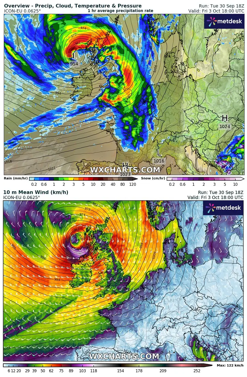
According to the latest weather models, the impact could be significant. With violent winds and significant wave heights across Ireland and Scotland, then moving into the North Sea on Saturday.
The following video animation hints at the evolution of the Atlantic storm as it grazes across Western Europe from Friday through Sunday, the following weekend.
Let’s dig into the evolution of the potentially significant impact of ex-hurricane Humberto on Western Europe this Friday.
Fujiwhara effect of hurricane Humberto and Imelda sends an intense storm across the Atlantic
What’s impressive about the currently active hurricanes Humberto and Imelda is their rare interaction in the tropical western Atlantic.
This week, a remarkable process known as the Fujiwhara effect is taking place. Both tropical cyclones dance around each other and interact in their behavior, an effect that has not been observed for quite a long time.
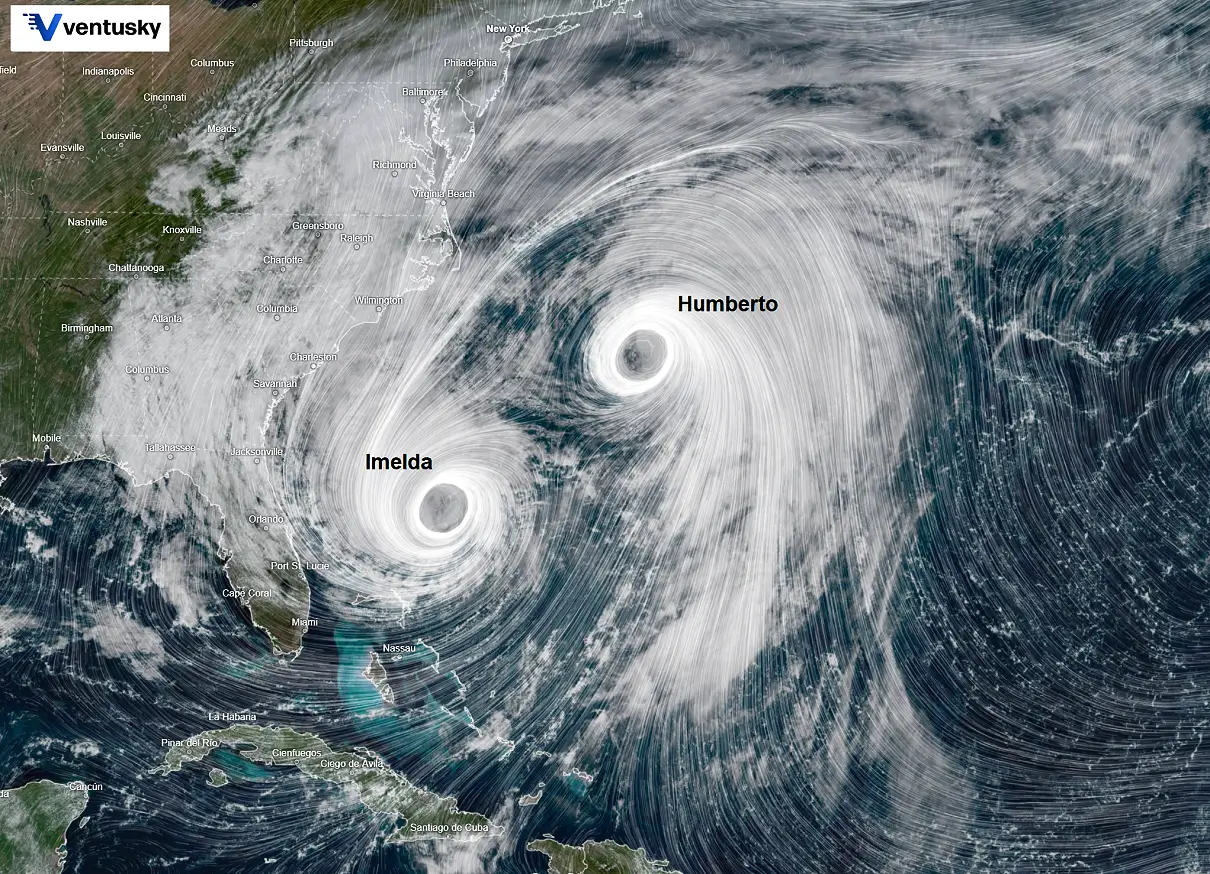
Humberto and Imelda are closer than any hurricane since at least the 1960s, and they are now connected in each other’s orbit, pivoting and interacting.
While Humberto is rapidly losing its tropical characteristics, Imelda will ingest Humberto’s high moisture and energy and pass over Bermuda before it also transitions into an extratropical low and heads out to the open Atlantic Ocean on Thursday.
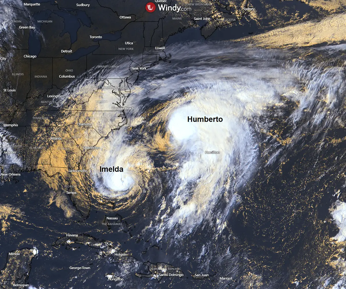
A good result of this rare Fujiwhara Effect is that Humberto helps steer Imelda away from the impact of the U.S. mainland. Without Humberto, Imelda could have gone due north and impacted the East Coast as a powerful hurricane.
On Wednesday, Humberto and Imelda were slightly less than 500 miles apart, but close enough for some interaction.
Thanks to Humberto, Imelda will be steered away and curve off to the northeast over the next few days. By Wednesday night, Humberto will lose its characteristics while Imelda nears Bermuda, impacting the island with hurricane-force winds.
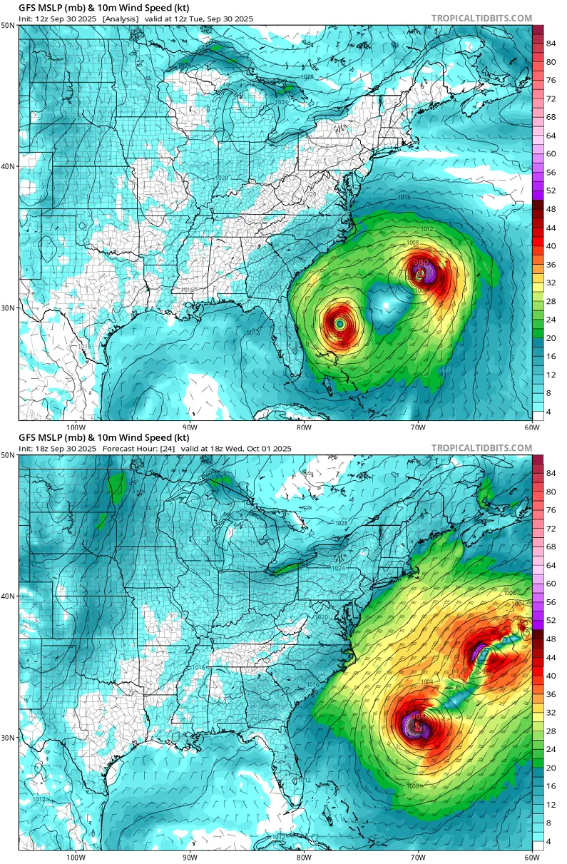
As both systems move further northeast, only one survives. The interaction with the general zonal flow accelerates Thursday’s extratropical storm, which heads towards Western Europe. The pressure drops below 950 mbar during rapid re-intensification, while winds significantly intensify.
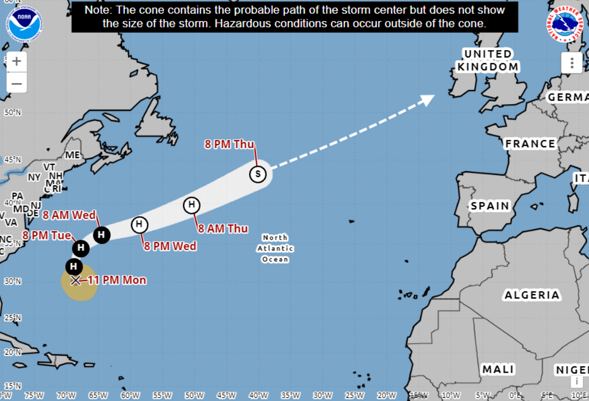
The system is forecast to graze into Western Europe by late Friday. The most likely scenario involves bringing the powerful storm to Northern Ireland and Scotland.
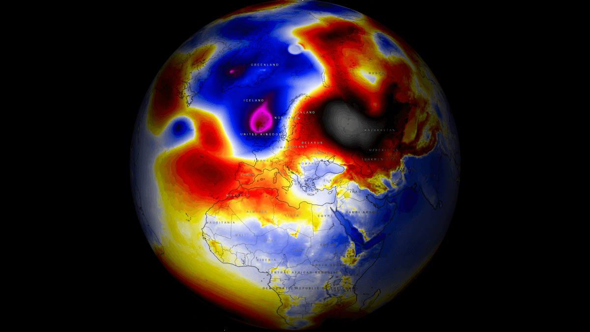
A deep trough develops over the North Atlantic, bringing a violent storm to Western Europe
The general weather pattern over the North Atlantic and Europe indicates the decaying Rex block over the eastern half of the continent. This week, the first cold outbreak hit central Europe, the Balkans, and the Mediterranean. The associated low will bring a severe weather outbreak to Greece and the Aegean Sea.
Further west, an Azoric high holds the progressive troughs over the far North Atlantic, with a deep wave emerging from the west. This wave rapidly deepens on Friday, delivering an intense Atlantic storm at the surface.
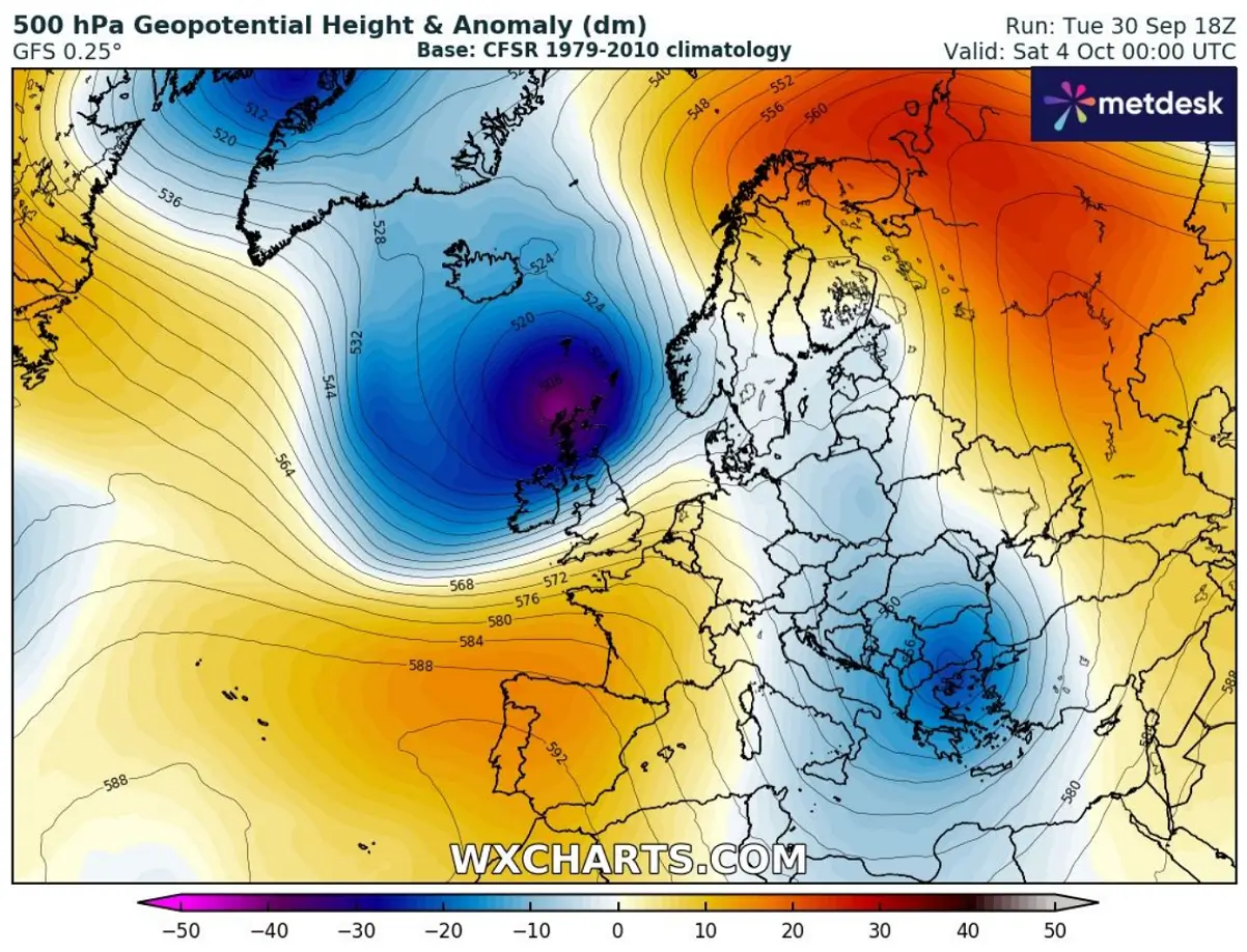
A powerful jet stream develops with the high-pressure and temperature gradient spread between the Azores and the North Atlantic. This helps to trigger a rapid intensification of surface cyclogenesis originating from the ex-hurricane Humberto, which acts as an extratropical storm.
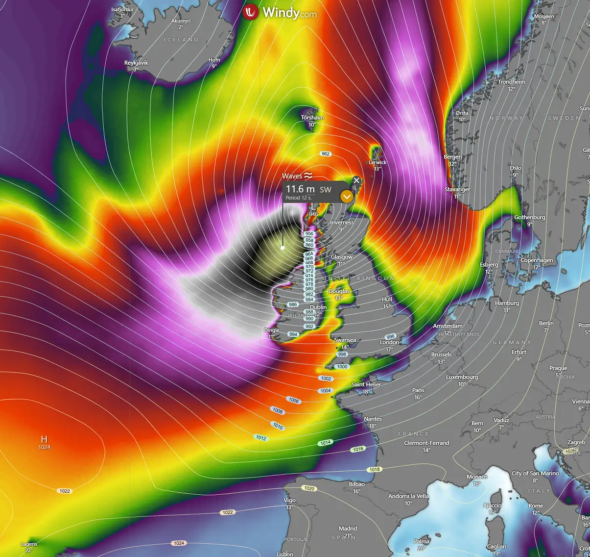
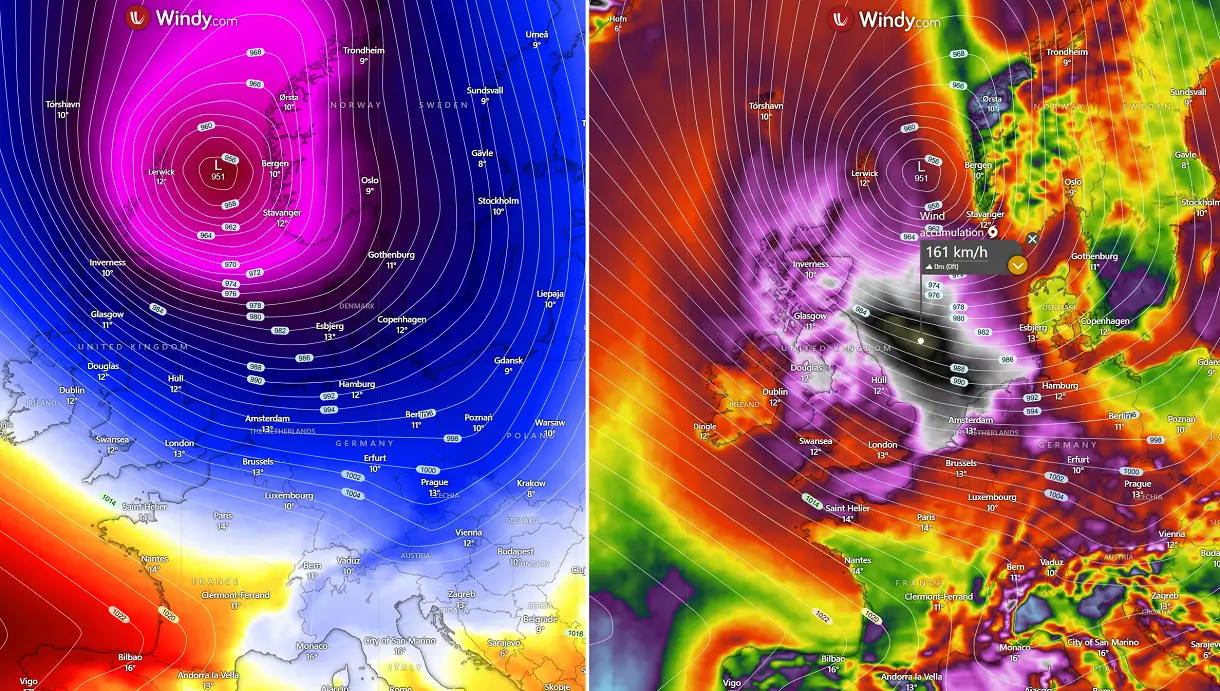
As the low reaches Western Europe, its intensity will be near the peak, with the central pressure below 950 mbar. Per some weather models, the pressure could be close to 940 mbar before it interacts with the land of Northern Ireland and Scotland on Friday night.
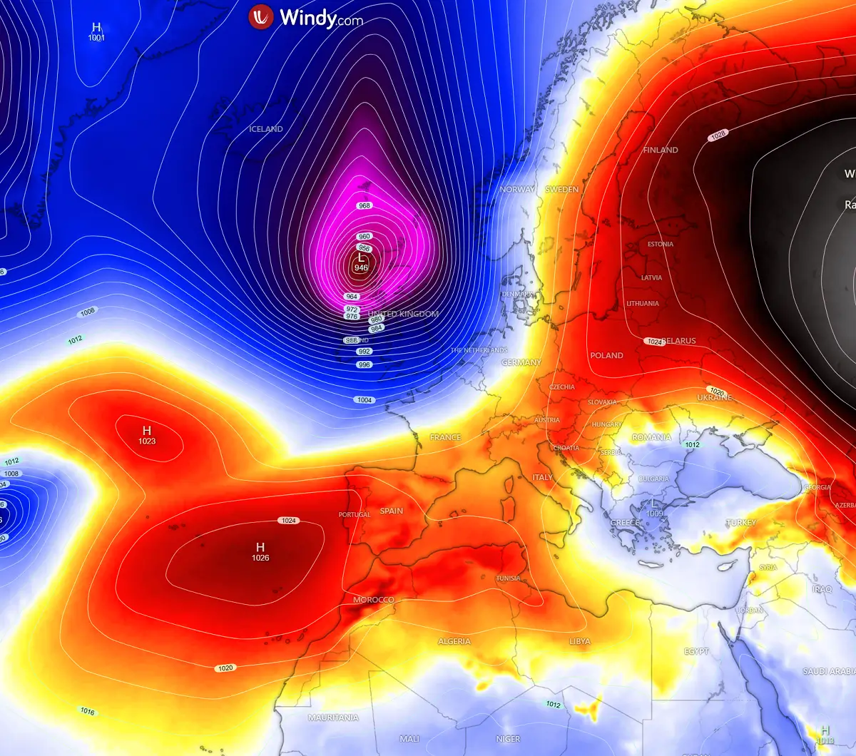
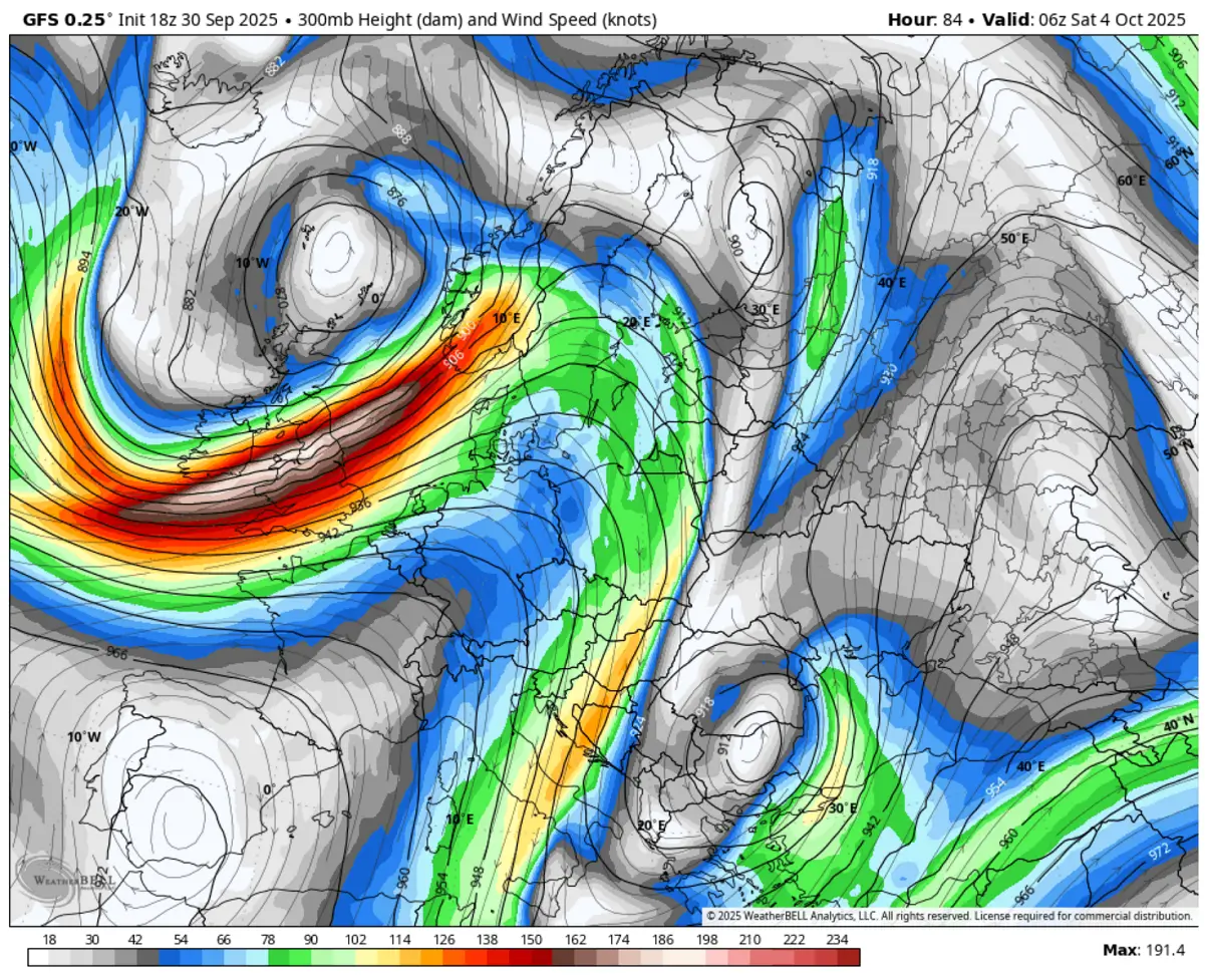
The associated jet stream further intensifies as the pressure and temperature gradients between Western Europe and the continent tighten. Therefore, the upper-level winds will be violent, reaching an average wind speed of near 190 knots (350 km/h) at 300 mbar—approximately 9.000 metres above the ground.
Imagine those travelling across the jet stream core could experience severe turbulence then.
Let’s examine Storm Amy’s evolution as it grazes Western Europe Friday night.
Ireland and Scotland brace for a significant impact of the Atlantic storm on Friday
By Friday afternoon, the core of Storm Amy will reach the western coast of Scotland (Outer Hebrides) and Northern Ireland. The severe wind impact will spread across Ireland and the UK around midday on Friday.
As is typically the case with these storms, the first rainy squalls will blast with the main cold front, and then the powerful force of the low will follow from the west.
Given the 72-hour time distance before the impact and the fact that Humberto is still far away from Europe, we are uncertain about Storm Amy’s exact track.
However, most weather models predict a potent impact on Western Europe. Where precisely the core will travel remains the greatest question, while the effects should bring severe, potentially damaging winds reaching 160-190 km/h.
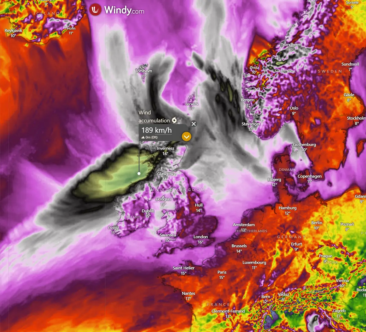
The large scale of this Atlantic storm will also significantly increase the wave heights as it gradually spreads towards the western coasts of Ireland, Northern Ireland, and Scotland.
The highest waves could reach up to 12 metres as they approach the coasts.
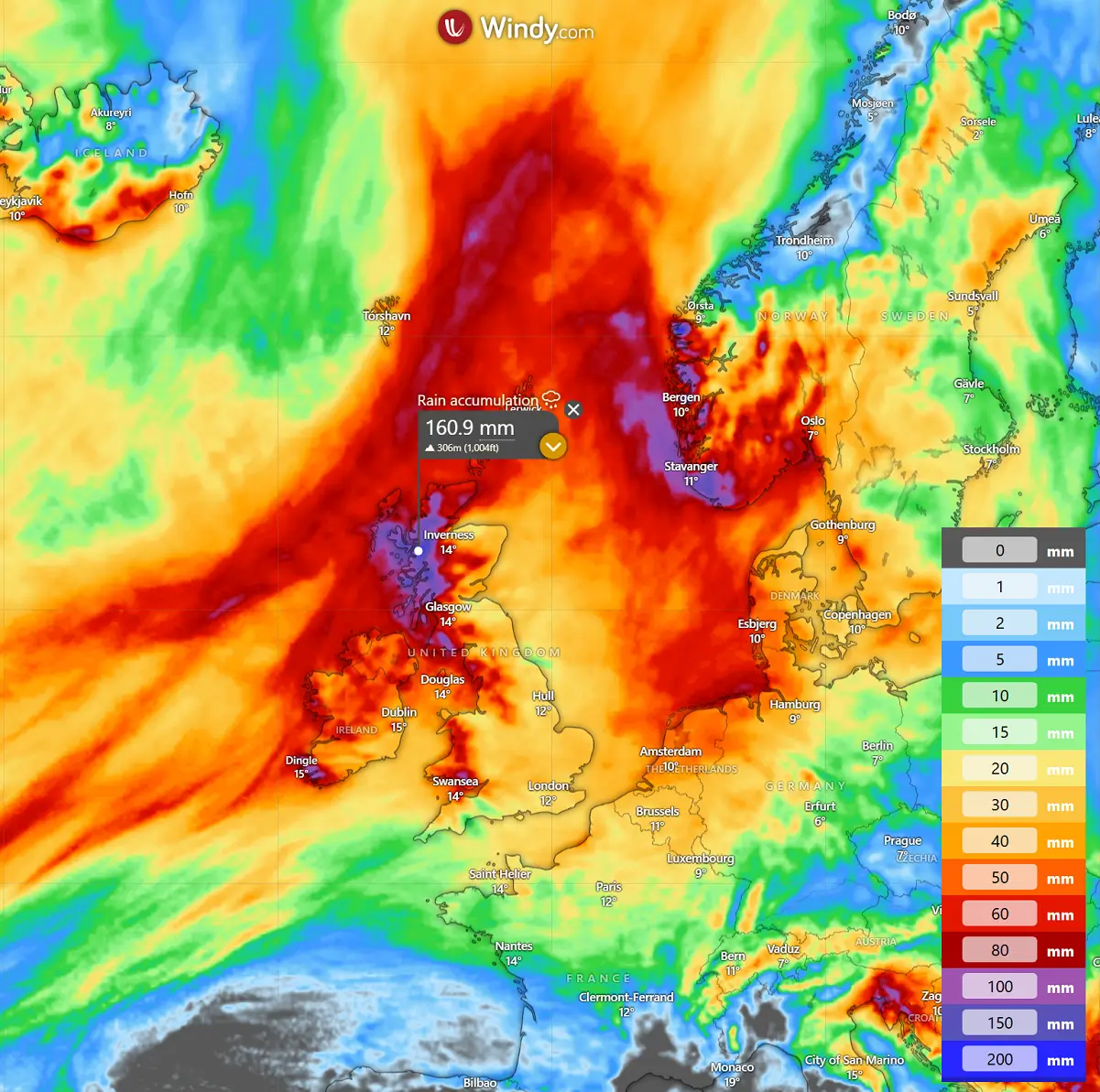
The storm will also bring high rainfall amounts, as the powerful winds will persist over the next few days. The orographic rainfall will dump high amounts of rain into the Scottish Highlands and over higher terrain in Ireland, Wales, and northern England.
Locally, more than 150 mm of rain is possible throughout Scotland from tonight through Sunday morning.
Once storm Amy crosses Scotland on Saturday, it remains intense with pressure holding around 950 mbar while emerging into the North Sea. At the same time, the main cold front of the system blasts into western Norway, but the impact of the wind on the back side of the low is more concerning.
The strong pressure gradient across the North Sea will push violent winds towards the Netherlands, northern Germany, and Denmark Saturday afternoon into the night. The peak wind gusts, with high waves, could reach above 120 km/h along the coasts.
Storm Amy will gradually diminish towards Sunday as the upper low fills and weakens while stalling to the west of the persisting upper ridge further east.
Wxcharts, WeatherBell, and Pivotalweather provided images for this article.
See also:
October 2025 to start with the first significant cold outbreak for Central Europe of the season