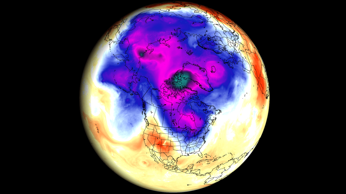
The latest weather forecasts for September show a rare Polar flow into the United States and Canada in the early days of the month. It is driven by pressure changes over the Northern Hemisphere, which are also creating an unusually weak start to the Stratospheric Polar Vortex, maintaining a dynamic pattern over North America.
These changes mark an abrupt end to the active Summer pattern over North America, switching directly into a Fall mode as the new month begins.
We will first look at the latest pressure anomalies over the United States and Canada, the rare September cross-polar flow pattern, and how these events will have a strong impact on the stratospheric Polar Vortex in its early stages.
SUMMER COMES TO AN END
As mentioned, August is the final month of the meteorological summer, which covers the three warmest months of the year. With September, the meteorological Fall will begin, which also covers the months of October and November.
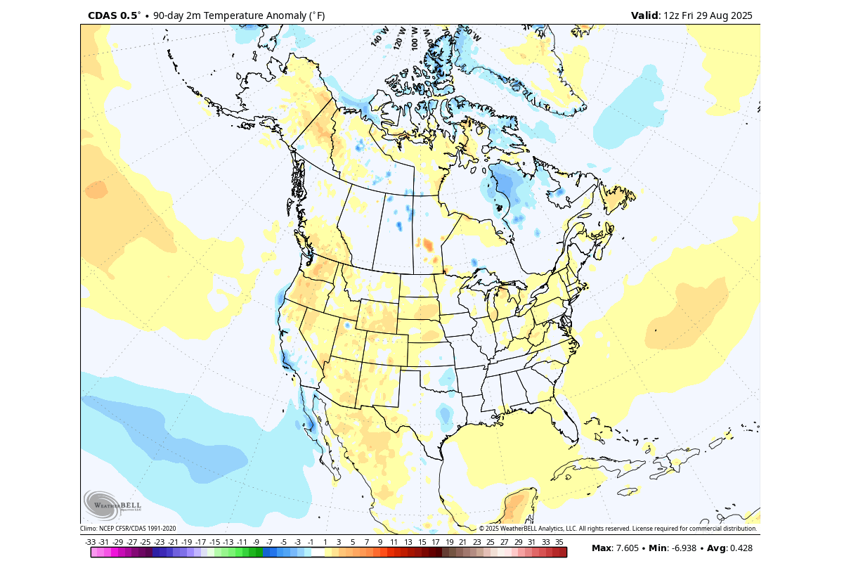
Below is the Summer 2025 temperature anomaly over the United States and Canada, which shows mostly warmer-than-normal conditions over the west-central United States and over the northeast. Central and eastern Canada, as well as parts of the eastern and southern United States, show normal to even below-normal summer temperatures, largely due to recent cold intrusions.
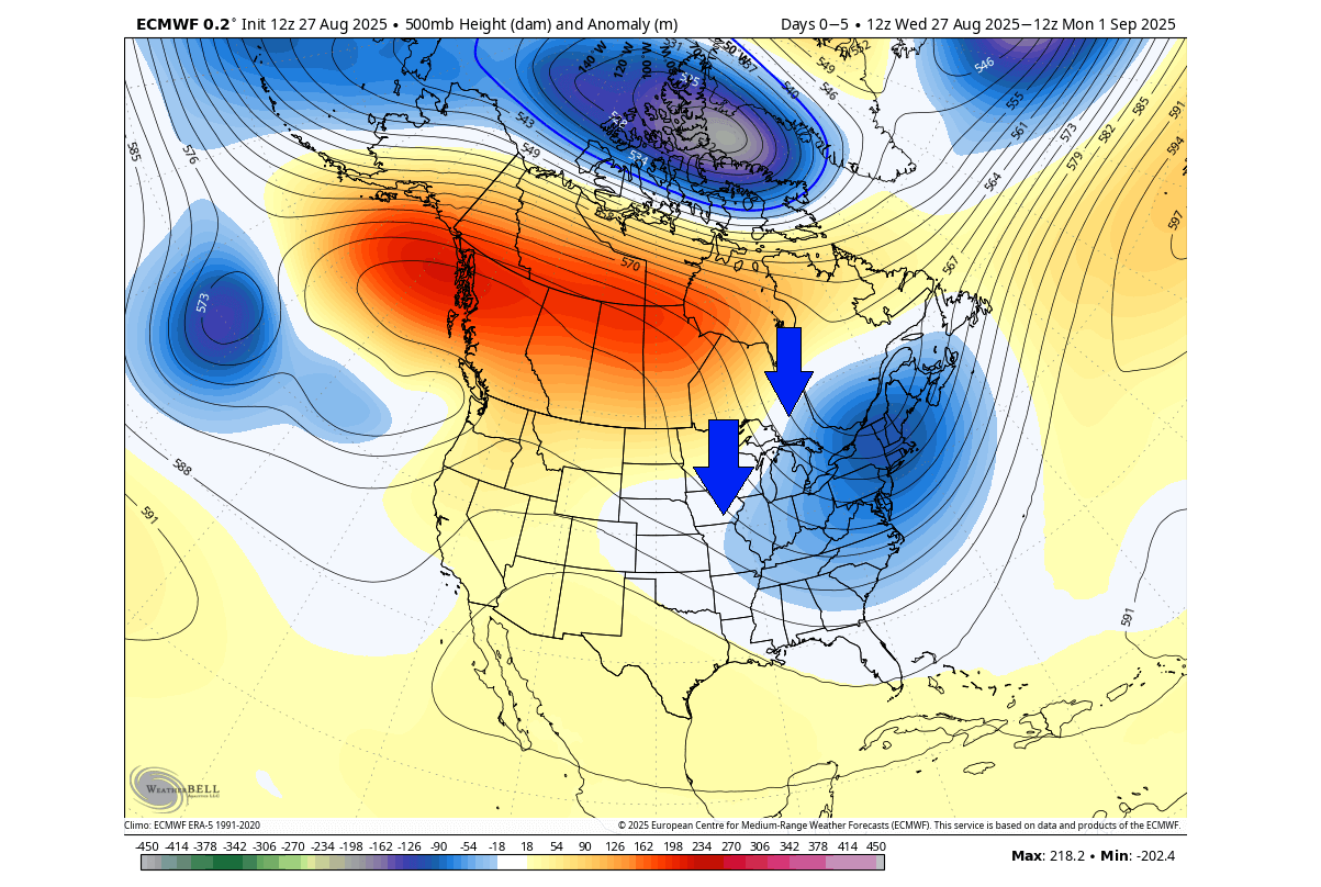
If you look at the image below, you can see the pressure pattern for the final days of August. A strong low-pressure area covers the eastern and northeastern United States, and a ridge rises over western Canada. This creates a strong northerly flow into the central and eastern United States.
We can see this colder air intrusion in the image below. Most of the United States is set to experience below-normal temperatures for this time of year, with the peak anomaly over the Midwest. Warmer temperatures are forecast under the high-pressure area over western Canada.
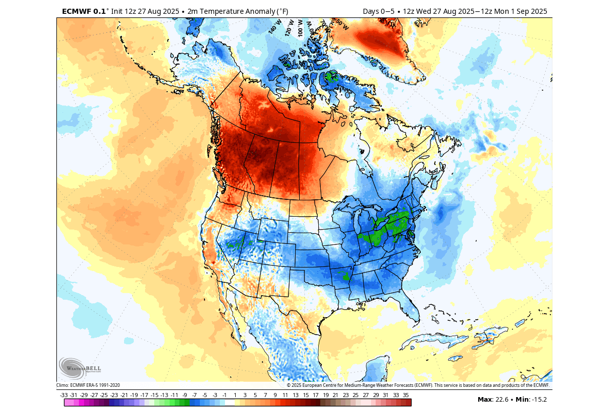
This is not the first such cooler air flow this summer, and an even stronger one is currently forecast for early September, powered by a rare early Fall polar flow.
A COLD SEPTEMBER POLAR FLOW
Pressure areas and anomalies typically determine how the air will move or flow across the Northern Hemisphere. There is a special type of pattern, called the “cross-polar flow”, which usually brings the coldest/lowest temperatures across the pole into the United States during Winter.
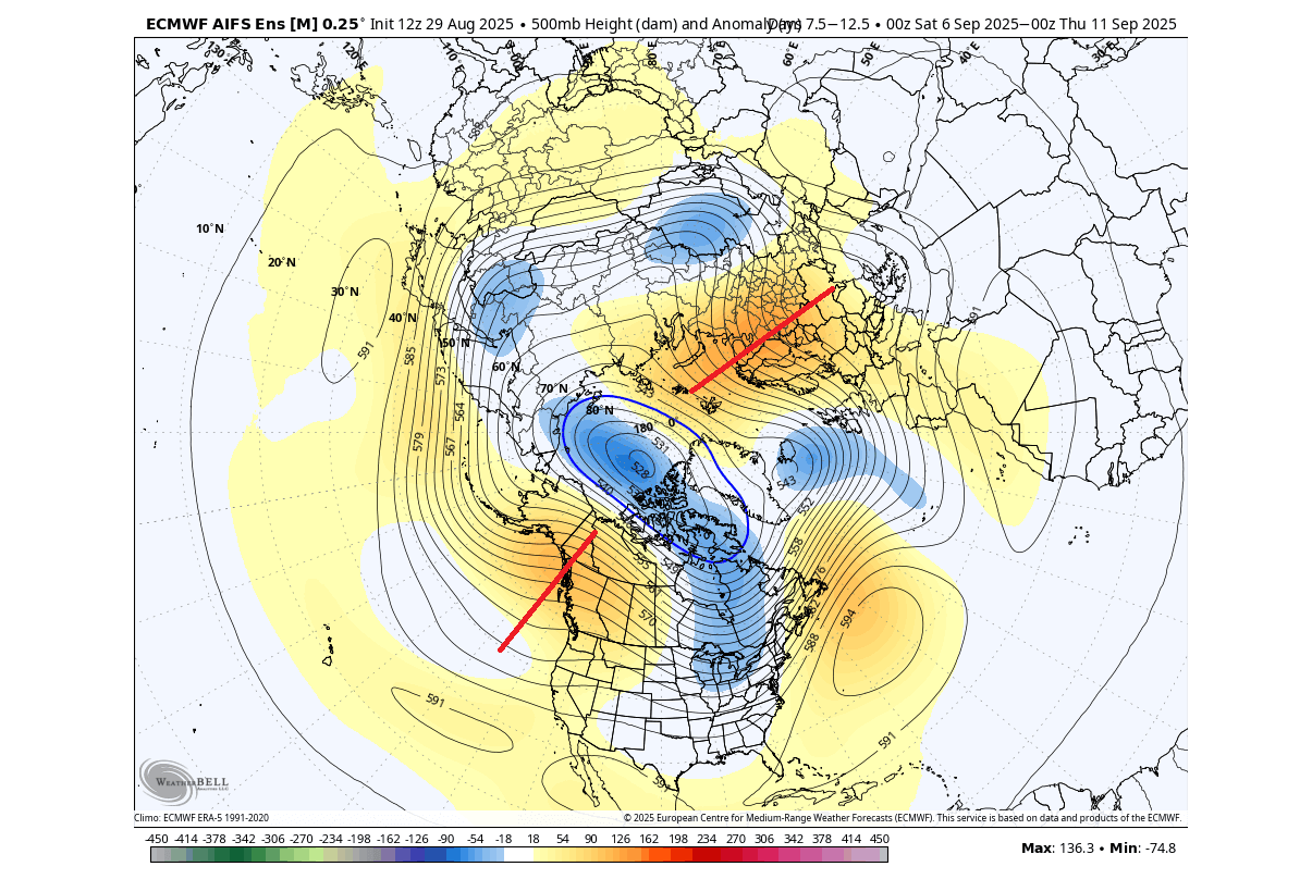
Below is the pressure anomaly forecast for the first week of September. You can see an amplified ridge over the northeast Pacific, and one expanding into the pole from the east. This squeezes the lower polar circulation, creating a corridor of colder air mass from across the polar regions into the United States, which is why it’s called a “cross-polar” flow.
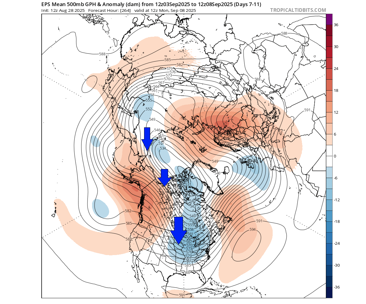
Of course, you need stronger pressure systems for this to work properly. This is why such setups are rare in early September, due to the pressure systems only slowly starting to get stronger, as the seasonal cooling gets underway.
To visualize the cross-polar flow, we added the 700mb (3km/1.8miles) level temperature forecast. You can see the colder core of the system reconnecting with the main polar air mass. You can nicely see how the colder air was transported.
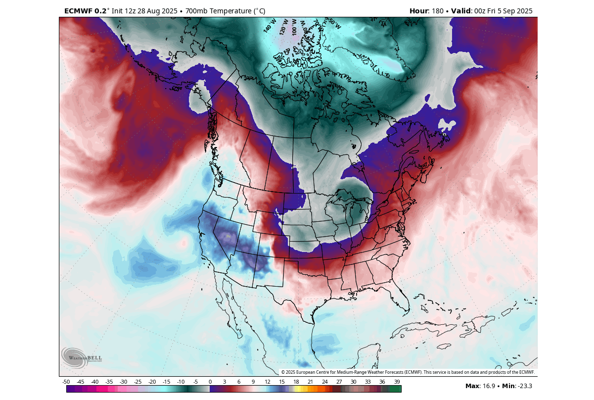
To understand this event even better, we produced a high-resolution video animation below from the forecast data. The video shows how the cross-polar flow pulls down the colder airmass, and how overall weather dynamics work to transport polar air into North America.
Looking at the temperature anomalies for the first week of September, you can very nicely see the large spread of the colder airmass. This event is expected to bring unseasonably cold weather to much of the central, southern, and eastern United States, while western Canada sits under a warm ridge.
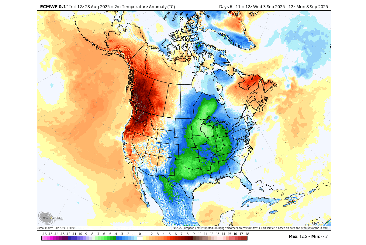
We also decided to use a single forecast image instead of a 5-day average, as this shows the potential strongest cold anomaly and shows more local details about the event itself. As you can see, you have a very abnormally cold air, sourced from the polar regions. Most of the United States will be covered by a colder air mass next week.
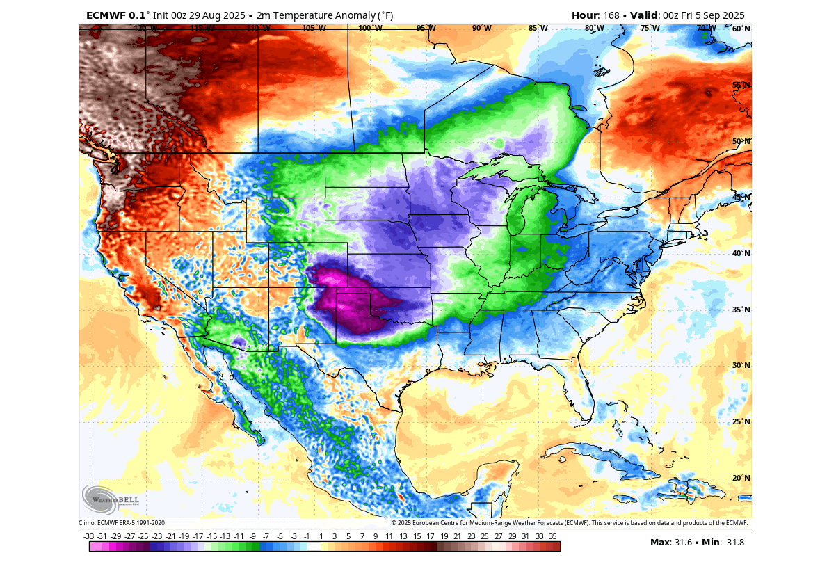
Also notice the strong warm anomalies across the Pacific Northwest, brought by the airmass movement under the high-pressure ridge over western Canada.
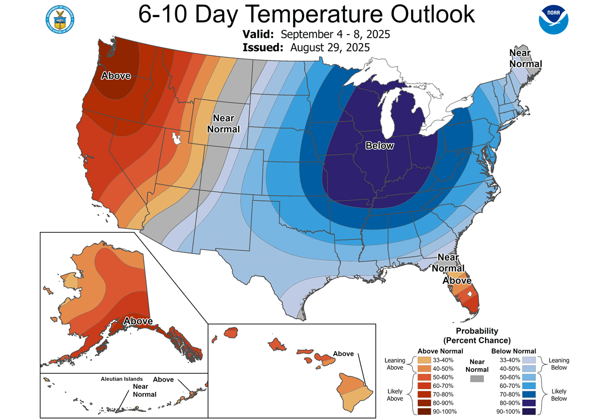
Even the official temperature outlook for the first week of September already calls for some unseasonable weather and a strong break in the Summer weather pattern. While this event may not last long, it serves as a stark reminder that every weather pattern can be disrupted and reversed, resulting in cold.
Looking at precipitation for the first week of September, you only see The Plains getting more rain than normal, or areas like the upper Midwest. At the same time, because this polar air is mostly dry, areas across the eastern United States show a larger rainfall deficit.
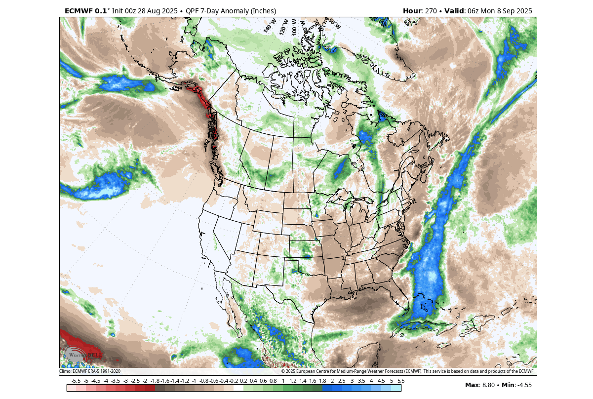
Less rainfall is also forecast across the Pacific Northwest, due to the presence of a high-pressure system.
As this pressure pattern will persist for a while over the Northern Hemisphere, it will also begin to affect the lower levels of the stratospheric Polar Vortex.
UNUSUAL POLAR VORTEX IMPACT
The Polar Vortex is a large cyclonic area that spins over the entire Northern Hemisphere and re-emerges every Fall. It plays a key role in weather development over the Winter and into Spring. For this reason, we must be aware of any changes in its dynamics, especially now that it’s just starting to form.
We separate the entire Polar Vortex into an upper (stratospheric) and a lower (tropospheric) part. They both play their role differently, so we monitor them separately. But it is also very important how both levels are connected. Image by NOAA-Climate.
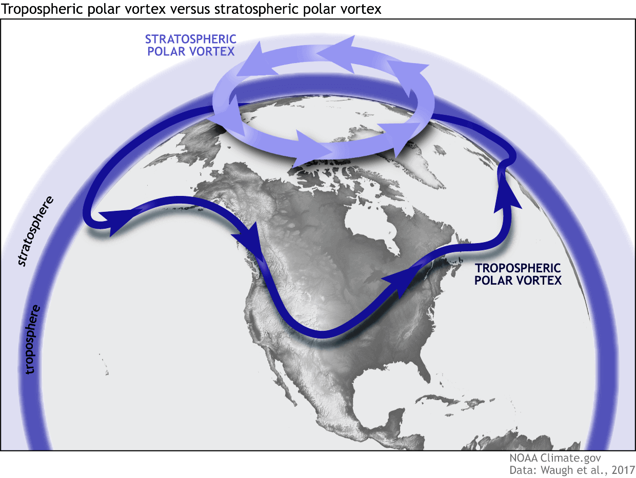
We usually refer to each level as the upper (stratospheric) or the lower (tropospheric) Polar Vortex. Their impacts are also different across each level, but their main modes are usually the same.
The Polar Vortex winter impacts can come in two main modes:
A strong/stable Polar Vortex usually means strong polar circulation and a stable jet stream. This contains the colder air in the far north, creating milder conditions for most of the United States and other mid-latitudes.
In contrast, a weak Polar Vortex creates a disrupted jet stream pattern and a strong weather response. As a result, it has a harder time containing the cold air, which can now more freely escape from the polar regions into the United States or other mid-latitude regions.
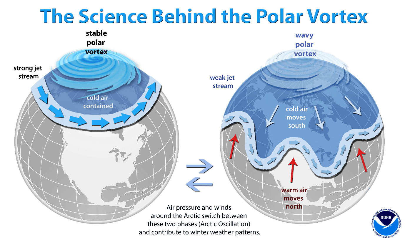
So, if you want a colder and snowier Winter, your best bet is a weak Polar Vortex. In nature, a weak Polar Vortex essentially means a breakdown of the stratospheric Polar Vortex.
But as we are in September, the Polar Vortex is only just starting to form. But the current events are still important, because it’s never too early to start weakening the Polar Vortex. And the upcoming pressure pattern is perfect for just that.
Below is the latest pressure anomaly forecast for the first week of September, and you can see the two strong high-pressure anomalies that we have mentioned before. These can put immense pressure on the overall polar circulation and the Polar Vortex, both in the lower levels and in the stratosphere.
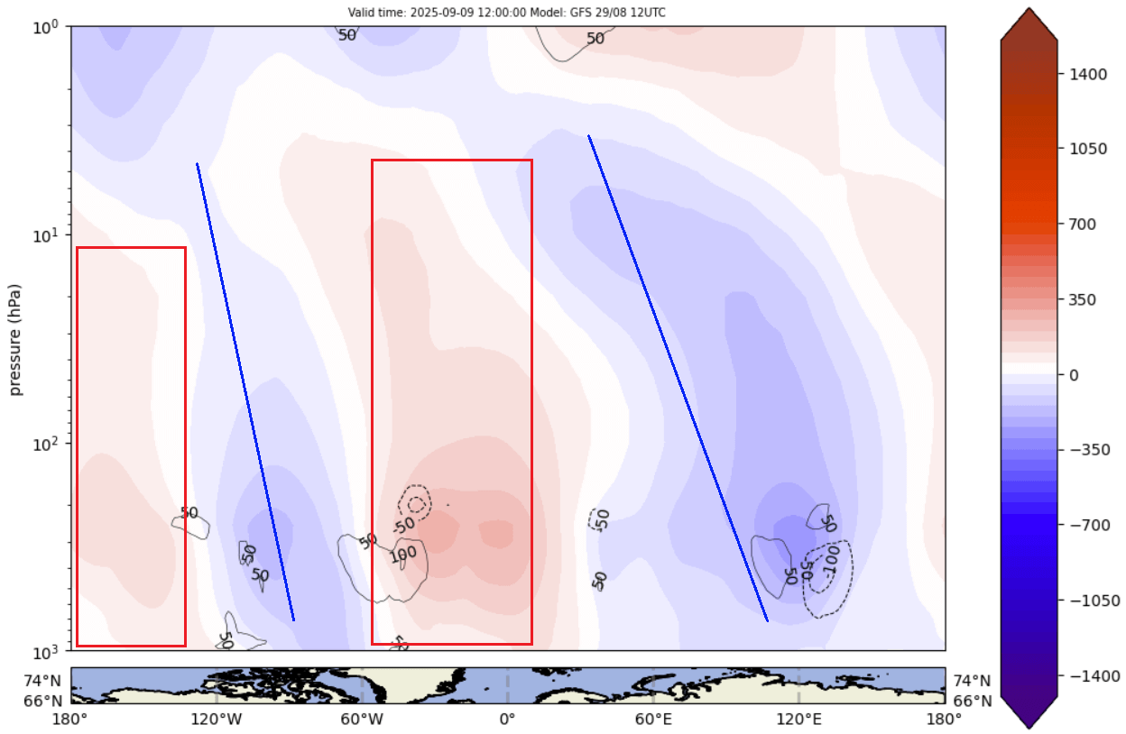
Below is an image that shows the day-10 forecast for pressure anomalies high above the polar regions. You can clearly see both high-pressure anomalies reaching far up into the stratosphere, disrupting the very early stages of the Polar Vortex development.
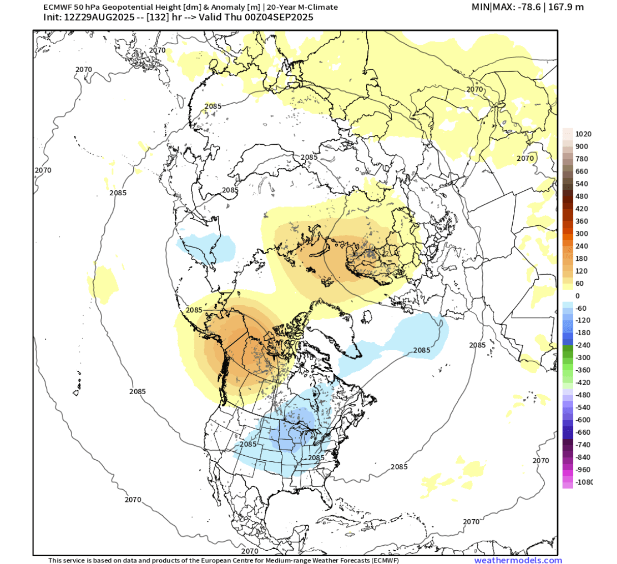
You can better see that if we look at the stratospheric Polar Vortex anomaly at the 50mb (20km/12.5 miles) level. Notice the two large areas of higher pressure, which are the anomaly from the pattern in the lower levels. You can also see a low-pressure zone over the United States, reaching into the stratosphere from below.
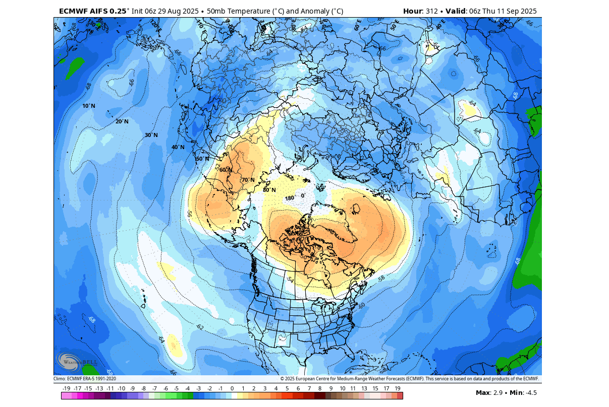
If we look at the temperature forecast at the same level of the stratosphere, you can see a warm anomaly over the polar regions. Despite being in the very early stages, a Polar Vortex always features a cold core. Seeing warm anomalies in the developing core really indicates that a weaker Polar Vortex is in the works.
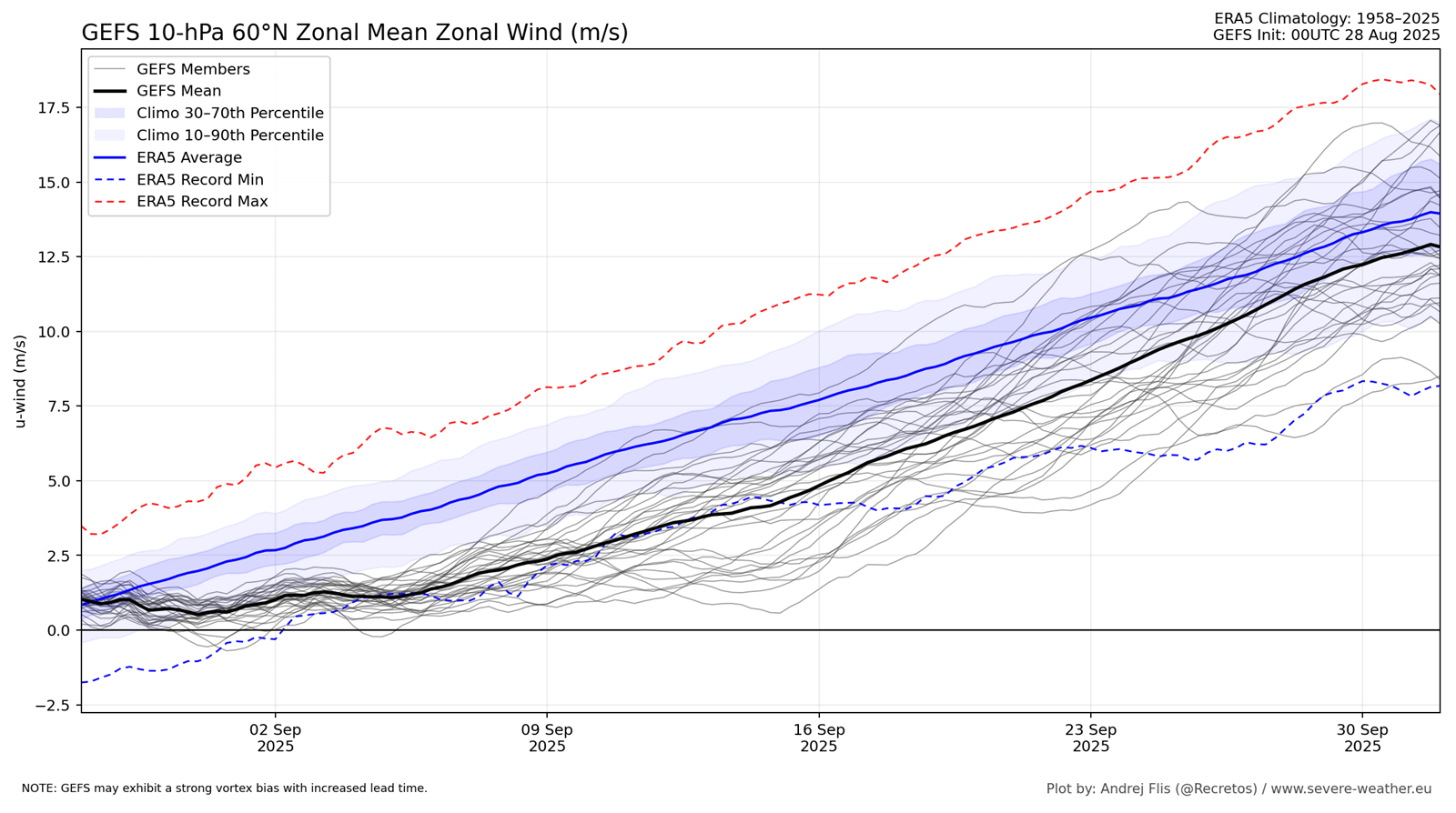
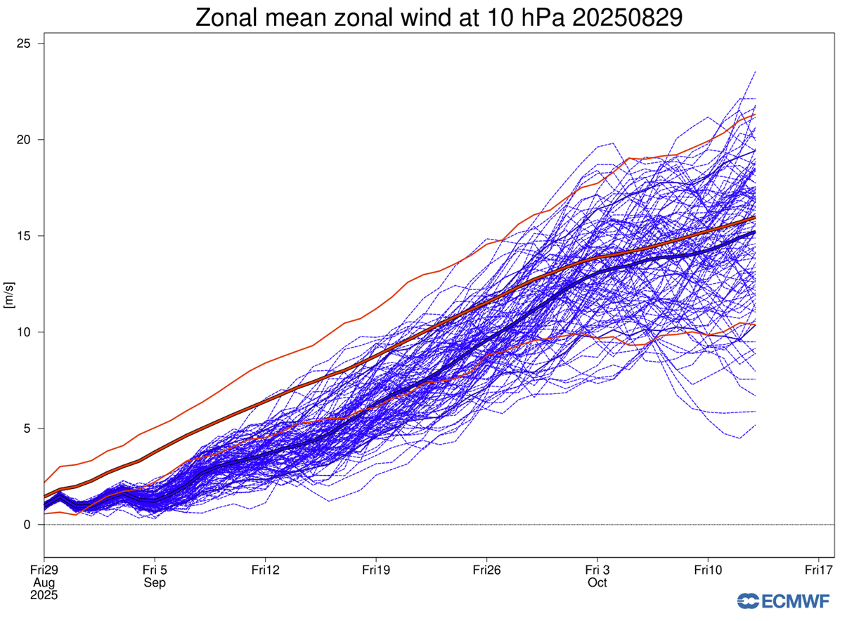
We can see the weakening effect of these events on the stratospheric Polar Vortex by looking at the extended-range forecast. Stratospheric zonal winds are used as a relative measure of the Polar Vortex strength. And below you can very nicely see that the Polar Vortex will be running at record low strength for a large part of the coming month.
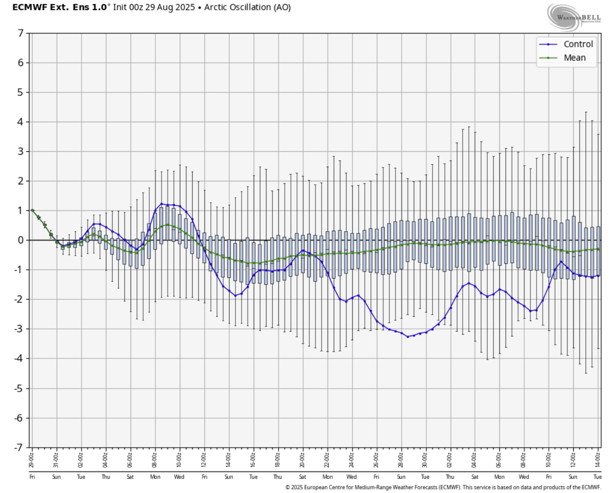
We also have a simple measure to analyze the state of the lower-level circulation. It’s simply called an AO index, and below you can see its extended range forecast. It shows mostly negative values, indicating weaker lower-level circulation, which is expected to impact weather patterns over the Northern Hemisphere in the coming month.
We can better see the importance of these circulation changes if we look at the actual extended range forecasts.
A DYNAMIC WEATHER PATTERN FOLLOWS
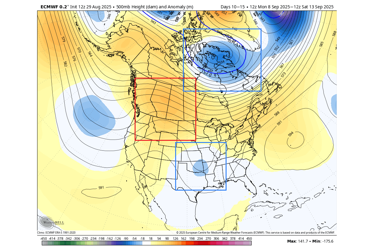
Looking at the latest forecast for the second week of September, you can see a very dynamic pattern. A low-pressure area is located over northern Canada, resulting in a more northerly flow. The second low-pressure area is located over the southern United States and is likely going to be the leftover from the strong polar flow next week.
You can see this reflected in the image below, which shows the temperature forecast for the same period. A colder air mass still spreads around the Great Lakes and stays over the southern plains. We can still see that the warm anomaly under the ridge persists over western Canada.
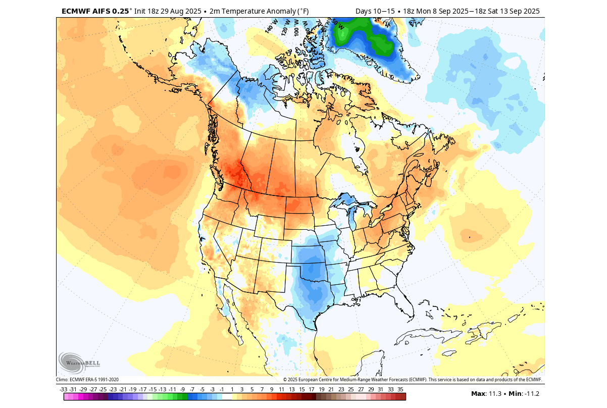
This is just the latest forecast trend, which very often seems to understate the cooler anomalies. So as we get closer to this period, it is likely that a cooler period can prevail over a larger area of the United States, if the pressure pattern persists, as we have seen a few times this summer.
EXTENDED RANGE FORECAST
Looking deeper into the seconf half of the month, we have to use the extended range forecast to analyze the expected dvelopment.
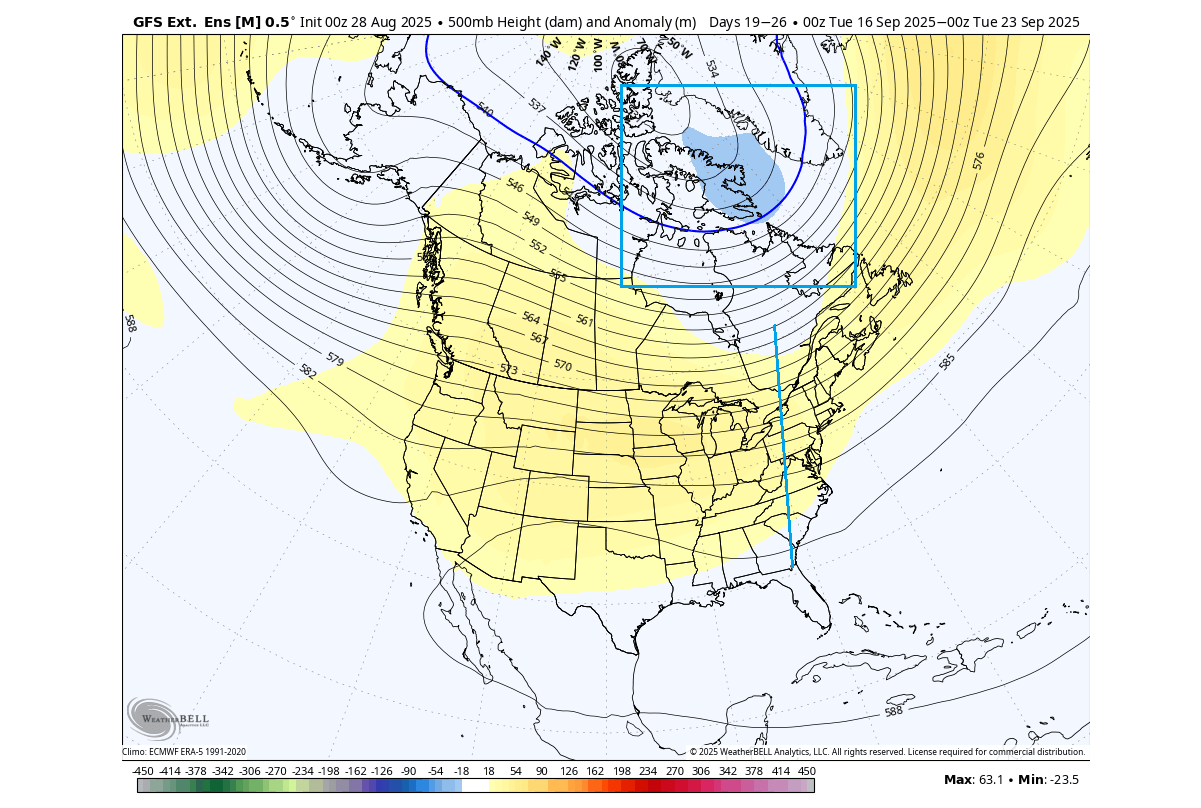
The image below shows the pressure pattern forecast for the third week, indicating a continued low-pressure area over northern Canada. But there is an extension hinted down into the eastern United States, while a high-pressure anomaly still persists over western Canada.
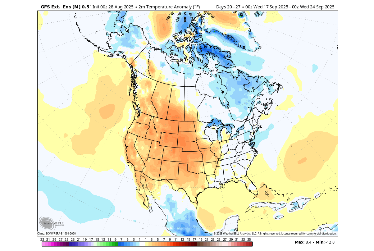
We can see something going on over the eastern United States in the temperature forecast. It nicely shows the connection up into the cooler airmass over northern Canada, maintaining normal temperatures over the eastern United States. At the same time, we can see a large area of above-normal temperatures over the rest of the United States, under a high-pressure dome.
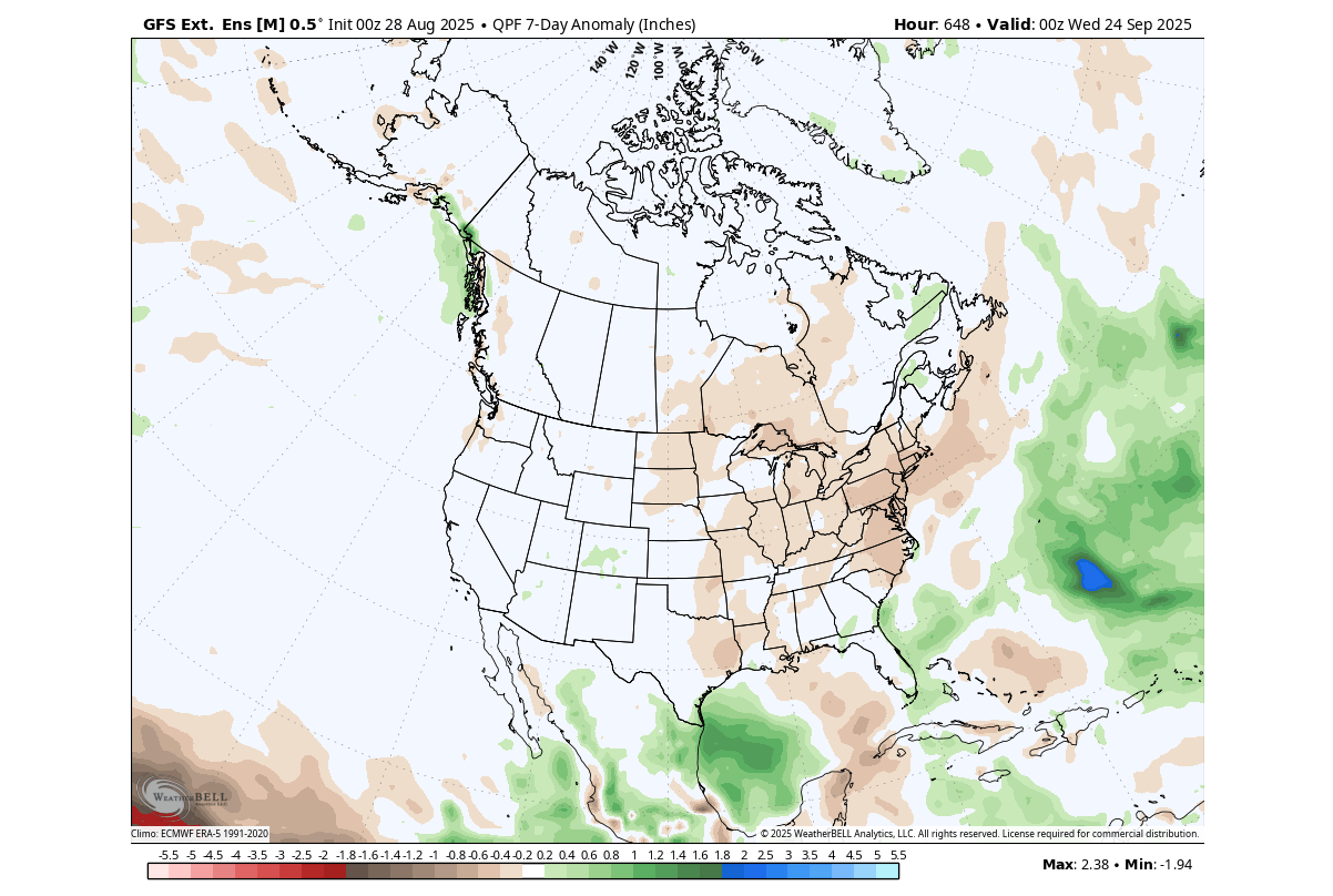
The precipitation forecast for this period is interesting, as it shows a drier forecast over the eastern and south-central United States, the upper Midwest, and parts of southeastern Canada. Not many areas inside North America show above-normal rainfall, except for far eastern Canada and parts of the west-central United States.
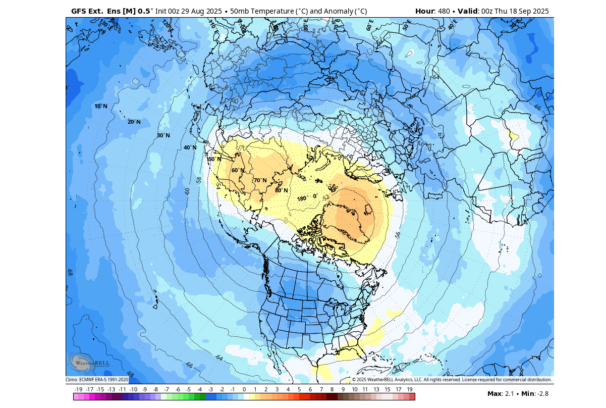
Looking also at the extended range forecast for the Polar Vortex in the stratosphere, you can see warm anomalies in the core area. This is a clear sign that the Polar Vortex is forecast to remain weaker over the month, as the core is cooling more slowly than it should under normal conditions.
This unusual effect is also seen in the extended-range Polar Vortex forecast by ECMWF below. It shows the wind speeds running well below normal throughout the forecast period into October. This indicates a very interesting Polar Vortex season ahead.
These are just early forecasts, and we will release a full in-depth article once the Polar Vortex is properly formed in about two weeks.
Forecast images in the article are from WeatherBell and Weathermodels pages, using a commercial license.
We will keep you updated on the developing weather trends in the coming seasons, so make sure to bookmark our page. Also, if you have seen this article in the Google App (Discover) feed, click the like button (♥) or add us to preferred sources there to see more of our forecasts and our latest articles on weather and nature in general.
Don’t miss: Winter 2025/2026 Early Forecast: La Niña and Polar Vortex Shape a Cold Surprise Ahead